Winter 2023/2024
Updates: 2024 Motor Vehicle Use Map (MVUM) of Chugach and Tongass National Forests.
Updates: Contains the latest data by the National Park Service (NPS), Bureau of Land Management (BLM), United States Forest Service (USFS) and recreation.gov.
Early Winter 2023/2024
Updates: Contains the latest data by the National Park Service (NPS), Bureau of Land Management (BLM), United States Forest Service (USFS) and recreation.gov.
Late Fall 2023
Updates: White Mountains Winter Recreation
Updates: Contains the latest data by the National Park Service (NPS), Bureau of Land Management (BLM), United States Forest Service (USFS) and recreation.gov.
Late Summer 2023
Updates: Birch Creek, Denali
Updates: Contains the latest data by the National Park Service (NPS), Bureau of Land Management (BLM), United States Forest Service (USFS) and recreation.gov.
Summer 2023
New: Watch some interesting videos and audios, produced by the National Park Service.
Updates: Contains the latest data by the National Park Service (NPS), Bureau of Land Management (BLM), United States Forest Service (USFS) and recreation.gov.
Early Summer 2023
Updates: Contains the latest data by the National Park Service (NPS), Bureau of Land Management (BLM), United States Forest Service (USFS) and recreation.gov.
Late Spring 2023
New: We remastered all maps for higher quality and optimized data usage.
Updates: Contains the latest data by the National Park Service (NPS), Bureau of Land Management (BLM), United States Forest Service (USFS) and recreation.gov.
Early Spring 2023
Updates: Chugach, Tongass
Updates: Contains the latest data by the National Park Service (NPS), Bureau of Land Management (BLM), United States Forest Service (USFS) and recreation.gov.
Winter 2022/23
New: Earth isn't flat anymore! Check out the new globe view when you zoom way out.
Updates: Chugach, Dalton Highway, Denali
Updates: Contains the latest data by the National Park Service (NPS), Bureau of Land Management (BLM), United States Forest Service (USFS) and recreation.gov.
Early Winter 2022
New: Hyperlocal weather data for every Point of Interest (POI).
Updates: Contains the latest data by the National Park Service (NPS), Bureau of Land Management (BLM), United States Forest Service (USFS) and recreation.gov.
Fall 2022
New: Current weather data and 10-day-forecast powered by Apple Weather
Updates: Contains the latest data by the National Park Service (NPS), Bureau of Land Management (BLM), United States Forest Service (USFS) and recreation.gov.
Late Summer 2022
Updates: Susintna River / Alaska Range, Tiekel Corridor, Richardson Hwy Corridor / Tangle Lakes, Cantwell, Steese and White Mountains
Updates: Alaska Maritime National Wildlife Refuge, Caines Head, Chena River, Chugach, Denali, Fort Abercrombie, Hatcher Pass, Kachemak Bay, Kodiak, Point Bridget, Shuyak Island
Updates: Contains the latest data by the National Park Service (NPS), Bureau of Land Management (BLM), United States Forest Service (USFS) and recreation.gov.
Summer 2022
New: Redesigned for iPad!
Updates: Alaska Maritime National Wildlife Refuge, Caines Head, Chena River, Chugach, Denali, Fort Abercrombie, Hatcher Pass, Kachemak Bay, Kodiak, Point Bridget, Shuyak Island
Updates: Contains the latest data by the National Park Service (NPS), Bureau of Land Management (BLM), United States Forest Service (USFS) and recreation.gov.
Summer 2022
Updates: Use the new POI search feature and find more than 40000 campgrounds, trailheads, lakes and other points of interest.
Updates: Contains the latest data by the National Park Service (NPS), Bureau of Land Management (BLM), United States Forest Service (USFS) and recreation.gov.
- Applied insect repellent to recently discovered bugs on iPads near you.
- No actual insects were harmed in the making of this latest production.
Early Summer 2022
Updates: Contains the latest data by the National Park Service (NPS), Bureau of Land Management (BLM), United States Forest Service (USFS) and recreation.gov.
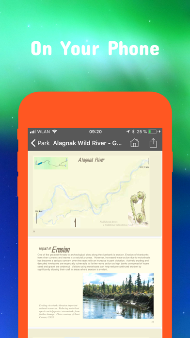
Updates: Alagnak Wild River, Aniakchak, Birch Creek, Glacier Bay, Katmai, Wrangell-St. Elias
Spring 2022
Updates: With the latest data by NPS, BLM, USFS
Updates: Alagnak, Aniakchak, Katmai, Tongass, Wrangell–St. Elias
Spring 2022
Updates: improved 3D maps
Updates: Kenai Peninsula
Winter 2021/2022
New: Maps in 3D!
Updates: Chugach, Fortymile / Steese Highway
Winter 2021
Updates for iOS 15 and iPad
Updates: Kenai Peninsula Winter Recreation
Winter 2021
updates: Fortymile / Steese Highway
Late Summer 2021
updates: Alagnak, Aniakchak, Becharof, Izembek, Kanuti, Katmai, Kenai, Kodiak, Tetlin
Summer 2021
new: Download maps directly from the new "maps" menu
new: Reorder maps
updates: Glacier Bay, Klondike Gold Rush, Wrangell-St. Elias
Spring 2021
updates: Yukon-Charley Rivers
Spring 2021
fixed: app didn't start on iOS 12 devices
updates: Alagnak, Aniakchak, Katmai