Do you have your favourite GPX or KML tracks and routes and want to see them in detail on your iPhone & iPad, or you just want to head into the mountains and record your adventure? No matter what kind of traveller you are, GPX Viewer PRO offers all this and more.
THE ABILITY TO IMPORT GPX AND KML FILES
Import your favorite GPX and KML files directly from your phone and continue exploring old tracks and routes, or explore new horizons of your country and go and see unexplored stretches. Show multiple tracks, routes and waypoints on various map types. Review and analyze track statistics and charts. Use this app as a simple navigation tool with location tracking which allows following GPS position and map rotation.
MAIN FEATURES
• Measure tracks and routes, speeds, climbs, lengths and various other parameters important for hiking
• You can view the resulting data in graphs and compare with previous activities
• Import tracks, routes and waypoints from GPX or KML format and view their parameters
• External track planning via our free service Trackbook - https://trackbook.online
• Storage of tracks, routes and waypoints directly on the device or their subsequent export to GPX or KML for other purposes
USER INTERFACE
• Easy to use and simple user interface
• Support for dark and light color schemes
ONLINE MAPS
• Wide variety of online maps like Apple Maps, OpenStreetMap, OpenTopoMap, ÖPNVKarte, CyclOSM, Mapbox, HERE, Thunderforest, Maptiler
OFFLINE MAPS
• Detailed worldwide offline vector maps based on OpenStreetMap data
• Wide variety of offline map styles from city to outdoor oriented styles, preview: https://go.vecturagames.com/offline
• Monthly updates with improved data
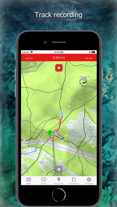
TRACK RECORDING
• Record tracks with speed and elevation
SIMPLE NAVIGATION TOOL
• Location tracking with follow GPS and rotate map features
• Shows actual speed, elevation and course
TRACKS AND ROUTES
• Import tracks and routes from GPX and KML files stored in iCloud or device storage
• Analyze information and statistics for tracks and routes
• View charts (graphs) like elevation and speed profile for tracks and routes
• View charts of other track data like cadence, heart rate, power and air temperature
• Adjust track and route line color
WAYPOINTS
• Import waypoints from GPX and KML files stored at iCloud or device storage
• Detailed waypoint information
• Adjust waypoint color and icon
• Add waypoints with long press
TRACKBOOK INTEGRATION
• Synchronize tracks and waypoints created on our free service Trackbook - https://trackbook.online
GPX Viewer PRO is the tool for travel and outdoor activities, be it hiking or biking, also via the app but also for free via https://trackbook.online
EULA: https://vecturagames.com/eula_gpxviewerproios