ArcGIS Field Maps

ArcGIS Field Maps


Free

24.1.1for iPhone, iPad and more
5.5
113 Ratings
ESRI
Developer
163.9 MB
Size
Apr 2, 2024
Update Date
Productivity
Category
4+
Age Rating
Age Rating
4+
Apps in this category do not contain restricted content.
9+
Apps in this category may contain mild or occasional cartoon, fantasy or real-life violence, as well as occasional or mild adult, sexually suggestive or horrifying content and may not be suitable for children under 9 years of age.
12+
Apps in this category may contain occasional mild indecent language, frequent or intense cartoon or real-life violence, minor or occasional adult or sexually suggestive material, and simulated gambling, and may be for children under 12 years of age.
17+
You must be at least 17 years old to access this App.
Apps in this category may contain frequent and intense offensive language; Frequent and intense cartoon, fantasy or realistic violence: frequent and intense adult, scary and sexually suggestive subjects: as well as sexual content, nudity, tobacco, alcohol and drugs, may not be suitable for children under 17 years of age.
ArcGIS Field Maps Screenshots
ArcGIS Field Maps posterArcGIS Field Maps posterArcGIS Field Maps poster
ArcGIS Field Maps posterArcGIS Field Maps posterArcGIS Field Maps posterArcGIS Field Maps posterArcGIS Field Maps posterArcGIS Field Maps posterArcGIS Field Maps posterArcGIS Field Maps poster

About ArcGIS Field Maps

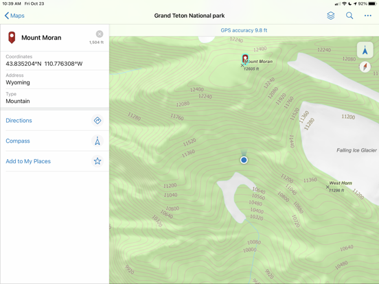
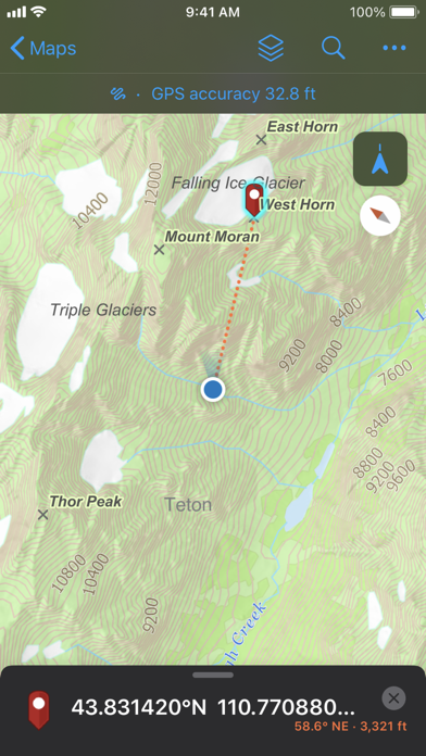
ArcGIS is available on your desktop, in a browser, and now on your iPhone or iPad.ArcGIS Field Maps is Esri’s premier maps app on mobile devices. Use Field Maps to explore the maps you make in ArcGIS, collect and update your authoritative data, and record where you’ve gone, all within a single location-aware app.

Key Features:
- View high quality maps created using ArcGIS.
- Download maps to your device and work offline.
- Search for features, coordinates, and places.
- Collect points, lines, areas, and related data.
- Mark up maps for your own use or to share with others.
- Use professional-grade GPS receivers.
- Collect and update data using the map or GPS (even in the background).
- Fill out easy-to-use, map-driven smart forms.
- Attach photos and videos to your features.
- Record where you've been and share your location.
- Streamline field workflows by integrating with other apps on your device.

Note: This app requires you have an ArcGIS organizational
account to collect and update data.

Note: Continued use of GPS running in the background can dramatically decrease battery life.
Show More

What's New in the Latest Version 24.1.1

Last updated on Apr 2, 2024
Old Versions
- Various bug fixes and improvements.
Show More
Version History
24.1.1
Apr 2, 2024
- Various bug fixes and improvements.
24.1.0
Feb 29, 2024
- Display read-only text on the form.
- Disable the Markup tool.
- Various bug fixes and improvements.
24.0.1
Jan 11, 2024
- Various bug fixes and improvements.
23.3.0
Oct 25, 2023
- Various bug fixes and improvements.
23.2.3
Aug 7, 2023
- Various bug fixes and improvements.
23.2.2
Jun 29, 2023
- Various bug fixes and improvements.
23.2.1
Jun 26, 2023
- Various bug fixes and improvements.
23.2.0
Jun 14, 2023
- Support for geofences created with custom Arcade expressions.
- Warn when GPS fix type threshold isn't met.
- Block manual collection or warn when it's used.
- Various bug fixes and improvements.
23.1.0
Feb 22, 2023
- Optimize offline map areas with tile package items.
- Update last known location frequency using app links.
- Share only last known location using MDM or app links.
- Use a smart card to sign in with iOS 16.
- Various bug fixes and improvements.
22.4.2
Dec 19, 2022
- Various bug fixes and improvements.
22.4.1
Dec 7, 2022
- Various bug fixes and improvements.
22.4.0
Nov 10, 2022
- Edit floor-aware layers.
- Improved pop-up support.
- Access online versions of downloaded maps.
- Use IPS for location sharing and geofences.
- Support for point and line geofences.
- Filter features using layer filters.
- Various bug fixes and improvements.
22.3.1
Aug 24, 2022
- Various bug fixes and improvements.
22.3.0
Jun 23, 2022
- Work with utility networks.
- Use indoor positioning.
- Receive alerts based on your location.
- Trigger location sharing with geofences.
- Capture GPS metadata for lines and polygons.
- Improved support for contingent values.
- Various bug fixes and improvements.
22.2.1
May 31, 2022
- Various bug fixes and improvements.
22.2.0
May 3, 2022
- Streamline data collection with contingent values.
- Various bug fixes and improvements.
22.1.0
Mar 28, 2022
- Support for form calculations.
- Simplify high-accuracy deployment with MDM settings.
- Various bug fixes and improvements.
21.4.0
Dec 15, 2021
- Access recently used templates during collection.
- Improved experience when measuring lines and areas.
- Support for Trimble DA2 GNSS receiver.
- Various bug fixes and improvements
21.3.1
Oct 7, 2021
- Various bug fixes and improvements.
21.3.0
Sep 22, 2021
- Various bug fixes and improvements.
21.2.3
Aug 30, 2021
- Various bug fixes and improvements.
21.2.2
Jul 26, 2021
- Various bug fixes and improvements.
21.2.1
Jul 13, 2021
- Various bug fixes and improvements.
21.2.0
Jun 30, 2021
- Support for data entry using a switch.
- Improve collection efficiency by copying a feature's shape and attributes.
- Delete all existing points in a line or polygon.
- Support for defining photo size and related types.
- Various bug fixes and improvements.
21.1.1
Apr 23, 2021
- Various bug fixes and improvements.

ArcGIS Field Maps FAQ

Click here to learn how to download ArcGIS Field Maps in restricted country or region.
Check the following list to see the minimum requirements of ArcGIS Field Maps.
iPhone
Requires iOS 14.5 or later.
iPad
Requires iPadOS 14.5 or later.
Apple Watch
Requires watchOS 6.0 or later.
iPod touch
Requires iOS 14.5 or later.
ArcGIS Field Maps supports English, Arabic, Catalan, Croatian, Czech, Danish, Dutch, Finnish, French, German, Greek, Hebrew, Hungarian, Indonesian, Italian, Japanese, Korean, Norwegian Bokmål, Polish, Portuguese, Romanian, Russian, Simplified Chinese, Slovak, Spanish, Swedish, Thai, Traditional Chinese, Turkish, Ukrainian, Vietnamese

ArcGIS Field Maps Alternative

You May Also Like

Get more from ESRI