Arizona Pocket Maps

Arizona Pocket Maps


Arizona Outdoor Guide


FreeOffers In-App Purchases

6.2for iPhone, iPad and more
9.1
127 Ratings
Alex Gugel
Developer
90.2 MB
Size
Feb 17, 2024
Update Date
Travel
Category
4+
Age Rating
Age Rating
4+
Apps in this category do not contain restricted content.
9+
Apps in this category may contain mild or occasional cartoon, fantasy or real-life violence, as well as occasional or mild adult, sexually suggestive or horrifying content and may not be suitable for children under 9 years of age.
12+
Apps in this category may contain occasional mild indecent language, frequent or intense cartoon or real-life violence, minor or occasional adult or sexually suggestive material, and simulated gambling, and may be for children under 12 years of age.
17+
You must be at least 17 years old to access this App.
Apps in this category may contain frequent and intense offensive language; Frequent and intense cartoon, fantasy or realistic violence: frequent and intense adult, scary and sexually suggestive subjects: as well as sexual content, nudity, tobacco, alcohol and drugs, may not be suitable for children under 17 years of age.
Arizona Pocket Maps Screenshots
Arizona Pocket Maps posterArizona Pocket Maps posterArizona Pocket Maps posterArizona Pocket Maps posterArizona Pocket Maps posterArizona Pocket Maps poster
Arizona Pocket Maps posterArizona Pocket Maps posterArizona Pocket Maps posterArizona Pocket Maps posterArizona Pocket Maps posterArizona Pocket Maps posterArizona Pocket Maps poster

About Arizona Pocket Maps

Be prepared! Plan your next trip to one of the great Arizona parks. Download maps and guides before you venture into the Wi-Fi free wilderness.

Discover

- 100+ national parks, state parks, monuments, forests
- 170+ neatly folded maps by the National Park Service, Bureau of Land Management, United States Forest Services, and other agencies.
- Motor Vehicle Use Maps (MVUM), Motor Vehicle Travel Maps (MVTM) and visitor maps for Arizona national forests.
- 1,000+ campgrounds and campsites
- 1,800+ trails and trailheads
- 54,000+ points of interests

Plan

- Download maps, park brochures, and newspapers. These downloads are ready when you are offline and off the grid in the great outdoors.
- Download arbitrary map sections as offline packs.
- Photo galleries, panorama views.
- Share links to parks and maps with friends

Have fun

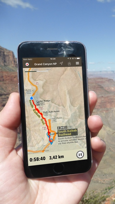
- GPS and GPX support: record your hikes, import GPX routes, tracks and waypoints for your hiking trails.
- Detailed national park information: alerts, news, visitor centers, campgrounds, driving directions, weather.
- Open your favorite maps app to get a route to the selected park.
- Current weather conditions, easy access to multi-day forecasts, sunrise and sunset times.
- Push notifications for park alerts, park news, weather warnings

So download maps and guides for:

Agua Fria
Apache-Sitgreaves
Arizona Strip
Camelback Mountain Park
Canyon de Chelly
Chiricahua
Coconino
Coronado
Dead Horse Ranch
Deem Hills
Fort Bowie
Gila Box Riparian
Glen Canyon
Grand Canyon
Ironwood Forest
Kaibab
La Posa
Lake Havasu
Lake Mead
Las Cienegas
Montezuma Castle
Navajo
Organ Pipe Cactus
Papago Park
Parashant
Petrified Forest
Phoenix Mountains
Prescott NF / City of Prescott
Red Rock / Sedona
Rio Salado Habitat Restoration Area
Sabino Canyon
Saguaro
San Pedro Riparian
Sonoran Desert
Sonoran Preserve
South Mountain Park
Sunset Crater Volcano
Tuzigoot
Vermilion Cliffs
Walnut Canyon
Wupatki

There are additional useful information and brochures for:

Alamo Lake SP, Boyce Thompson Arboretum SP, Buckskin Mountain SP, Casa Grande Ruins NM, Catalina SP, Cattail Cove SP, Colorado River SHP, Fool Hollow Lake SRA, Fort Verde SHP, Hohokam Pima NM, Homolovi SP, Hubbel Trading Post NHS, Jerome SHP, Kartchner Caverns SP, Lost Dutchman SP, Lyman Lake SP, McFarland SHP, Oracle SP, Patagonia Lake SP, Picaho Peak SP, Pipe Spring NM, Red Rock SP, Riordan Mansion SHP, River Island SP, Roper Lake SP, Slide Rock SP, Sonoita Creek SNA, Tombstone Courthouse SHP, Tonto NM, Tonto Natural Bridge SP, Tubac Presidio SHP, Tumacacori NHP, Verde River Greenway SNA, Yuma Territorial Prison SHP, Dankworth Pond SP, Granite Mountain Hotshots SMP, San Rafael SNP

- FULL ACCESS is available for a for $3.49/three month (after a free 3-days trial period) or $2.49/two months or $7.49/year. You can subscribe and pay through your iTunes account. The account will be charged for renewal within 24-hours prior to the end of the current period, and identify the cost of the renewal. Your subscription will automatically renew unless canceled at least 24 hours before the end of the current period. Auto-renew can be turned off anytime by going to your Account Settings in iTunes after purchase.

- Continued use of GPS running in the background can dramatically decrease battery life.

LEGAL
Terms of Use: https://www.icoat.de/pocketmaps/terms
Privacy Policy: https://www.icoat.de/pocketmaps/privacy
Show More

What's New in the Latest Version 6.2

Last updated on Feb 17, 2024
Old Versions
Late Winter 2023/2024

New: Maricopa County Parks maps
Updates: Contains the latest data by the National Park Service (NPS), Bureau of Land Management (BLM), United States Forest Service (USFS) and recreation.gov.
Show More
Version History
6.2
Feb 17, 2024
Late Winter 2023/2024

New: Maricopa County Parks maps
Updates: Contains the latest data by the National Park Service (NPS), Bureau of Land Management (BLM), United States Forest Service (USFS) and recreation.gov.
6.1
Dec 22, 2023
Early Winter 2023

Updates: Baaj Nwaavjo I’tah Kukveni - Ancestral Footprints of the Grand Canyon
Updates: Contains the latest data by the National Park Service (NPS), Bureau of Land Management (BLM), United States Forest Service (USFS) and recreation.gov.
6.0
Oct 26, 2023
Fall 2023

Updates: Box Canyon, Coronado National Forest, Kaibab National Forest
Updates: Contains the latest data by the National Park Service (NPS), Bureau of Land Management (BLM), United States Forest Service (USFS) and recreation.gov.
5.9
Aug 23, 2023
Summer 2023

New: Watch some interesting videos and audios, produced by the National Park Service.

Updates: Contains the latest data by the National Park Service (NPS), Bureau of Land Management (BLM), United States Forest Service (USFS) and recreation.gov.
5.8
Jul 3, 2023
Early Summer 2023

Updates: Contains the latest data by the National Park Service (NPS), Bureau of Land Management (BLM), United States Forest Service (USFS) and recreation.gov.
5.7
May 26, 2023
Late Spring 2023

New: We remastered all maps for higher quality and optimized data usage.

Updates: Contains the latest data by the National Park Service (NPS), Bureau of Land Management (BLM), United States Forest Service (USFS) and recreation.gov.
5.6
Apr 17, 2023
Spring 2023

Updates: Arizona Trail, Kaibab National Forest, Coconino National Forest, Arizona State Parks.
Updates: Contains the latest data by the National Park Service (NPS), Bureau of Land Management (BLM), United States Forest Service (USFS) and recreation.gov.
5.5
Feb 24, 2023
Early Spring 2023

Updates: Contains the latest data by the National Park Service (NPS), Bureau of Land Management (BLM), United States Forest Service (USFS) and recreation.gov.
5.4
Dec 29, 2022
Winter 2022/23

New: Earth isn't flat anymore! Check out the new globe view when you zoom way out.
Updates: Kaibab National Forest
Updates: Contains the latest data by the National Park Service (NPS), Bureau of Land Management (BLM), United States Forest Service (USFS) and recreation.gov.
5.3
Nov 16, 2022
Early Winter 2022

New: Current weather data and 10-day forecast powered by Apple Weather
New: Hyperlocal weather data for every Point of Interest (POI).
Updates: Contains the latest data by the National Park Service (NPS), Bureau of Land Management (BLM), United States Forest Service (USFS) and recreation.gov.
5.2
Oct 22, 2022
Fall 2022

Updates: Church Camp Road, Coyote Buttes, Middle Gila Canyons, Saddleback Mountain
Updates: Contains the latest data by the National Park Service (NPS), Bureau of Land Management (BLM), United States Forest Service (USFS) and recreation.gov.
5.1
Aug 24, 2022
Late Summer 2022

Updates: Contains the latest data by the National Park Service (NPS), Bureau of Land Management (BLM), United States Forest Service (USFS) and recreation.gov.
5.0
Jul 13, 2022
Summer 2022

New: Redesigned for iPad!
Updates: Contains the latest data by the National Park Service (NPS), Bureau of Land Management (BLM), United States Forest Service (USFS) and recreation.gov.
4.9
Jun 27, 2022
Summer 2022

Updates: Use the new POI search feature and find more than 54000 campgrounds, trailheads, lakes and other points of interest.
Updates: Adobe Dam, Buckeye Hills, Cave Creek, Coconino, Estrella Mountain, Lake Pleasant, McDowell Mountain, San Tan Mountain, Spur Cross Ranch, Usery Mountain,
Updates: Contains the latest data by the National Park Service (NPS), Bureau of Land Management (BLM), United States Forest Service (USFS) and recreation.gov.
4.8.1
Jun 6, 2022
- Applied insect repellent to recently discovered bugs on iPads near you.
- No actual insects were harmed in the making of this latest production.
4.8
May 20, 2022
Early Summer 2022

Updates: Contains the latest data by the National Park Service (NPS), Bureau of Land Management (BLM), United States Forest Service (USFS) and recreation.gov.
Updates: Alamo Lake, Buckskin Mountain, Cattail Cove, Catalina, Colorado River, Dead Horse Ranch, Lake Mead
4.7
Apr 4, 2022
Spring 2022

Updates: With the latest data by NPS, BLM, USFS
Updates: Coyote Buttes North (The Wave), Prescott, Phoenix
4.6
Feb 26, 2022
Spring 2022

Updates: improved 3D maps
4.5
Jan 22, 2022
Winter 2021/22: Be prepared for your adventure without WiFi or mobile service! Download Arizona maps for national parks, national monuments and state parks before you hike.Winter 2021/2022

New: Maps in 3D!
Updates: Coyote Buttes North (The Wave), Moss Wash, Kaibab
4.4
Dec 7, 2021
Winter 2021

Updates for iOS 15 and iPad
Updates: Cerbat Foothills, Moss Wash
4.3
Nov 7, 2021
Fall 2021

fix: bug prevented update of national park alerts and news
4.2
Sep 19, 2021
Fall 2021

updates: Petrified Forest
4.0
Jul 23, 2021
Summer 2021

updates: with the latest data provided by the National Park Service, U.S. Forest Service and Bureau of Land Management.
3.9
Jun 16, 2021
Summer 2021

new: Download maps directly from the new "maps" menu
new: Reorder maps
updates: Old Spanish Trail
3.8
Apr 25, 2021
Spring 2021

updates: Big Lake OHV, Coconino, Jerome OHV, Kaibab, New River OHV, Sedona OHV

Arizona Pocket Maps FAQ

Click here to learn how to download Arizona Pocket Maps in restricted country or region.
Check the following list to see the minimum requirements of Arizona Pocket Maps.
iPhone
Requires iOS 15.0 or later.
iPad
Requires iPadOS 15.0 or later.
iPod touch
Requires iOS 15.0 or later.
Arizona Pocket Maps supports English, German
Arizona Pocket Maps contains in-app purchases. Please check the pricing plan as below:
all pro features for 1 year
$7.49
all pro features for 2 months
$2.49
access all pro features
$3.49

Arizona Pocket Maps Alternative

You May Also Like

Get more from Alex Gugel