Early Spring 2024
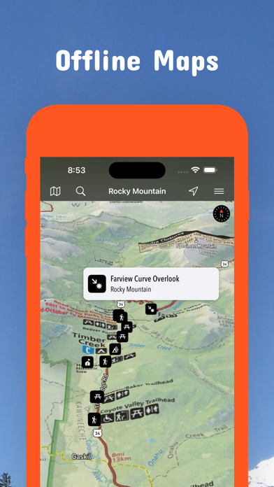
Updates: 21 1:100.000 Scale Topographic BLM Colorado Surface Management Status Maps.
Updates: Contains the latest data by the National Park Service (NPS), Bureau of Land Management (BLM), United States Forest Service (USFS) and recreation.gov.
Winter 2023/2024
Updates: Buzzard Gulch, Cerro Summit, Fruita Desert, Ridgway, Uncompahgre Plateau, White River
Updates: Contains the latest data by the National Park Service (NPS), Bureau of Land Management (BLM), United States Forest Service (USFS) and recreation.gov.
Early Winter 2023
Updates: Curecanti National Recreation Area
Updates: Contains the latest data by the National Park Service (NPS), Bureau of Land Management (BLM), United States Forest Service (USFS) and recreation.gov.
Late Fall 2023
Updates: Contains the latest data by the National Park Service (NPS), Bureau of Land Management (BLM), United States Forest Service (USFS) and recreation.gov.
Late Summer 2023
Updates: Florissant Fossil Beds, San Juan, White River
Updates: Contains the latest data by the National Park Service (NPS), Bureau of Land Management (BLM), United States Forest Service (USFS) and recreation.gov.
Summer 2023
New: Watch some interesting videos and audios, produced by the National Park Service.
Updates: Contains the latest data by the National Park Service (NPS), Bureau of Land Management (BLM), United States Forest Service (USFS) and recreation.gov.
Late Spring 2023
Updates: Contains the latest data by the National Park Service (NPS), Bureau of Land Management (BLM), United States Forest Service (USFS) and recreation.gov.
Late Spring 2023
New: We remastered all maps for higher quality and optimized data usage.
Updates: Contains the latest data by the National Park Service (NPS), Bureau of Land Management (BLM), United States Forest Service (USFS) and recreation.gov.
Spring 2023
Updates: Mesa Verde
Updates: Contains the latest data by the National Park Service (NPS), Bureau of Land Management (BLM), United States Forest Service (USFS) and recreation.gov.
Winter 2022/23
New: Earth isn't flat anymore! Check out the new globe view when you zoom way out.
Updates: Emigrant Trails, Great Sand Dunes, Old Spanish, Rocky Mountain, Sand Creek Massacre, Santa Fe Trail
Updates: Contains the latest data by the National Park Service (NPS), Bureau of Land Management (BLM), United States Forest Service (USFS) and recreation.gov.
Early Winter 2022
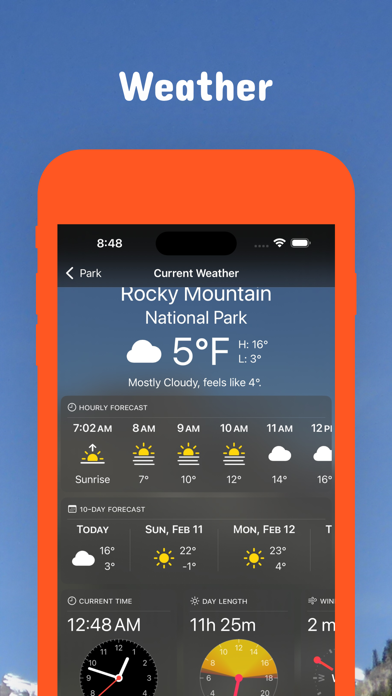
New: Hyperlocal weather data for every Point of Interest (POI).
Updates: Contains the latest data by the National Park Service (NPS), Bureau of Land Management (BLM), United States Forest Service (USFS) and recreation.gov.
Fall 2022
New: Current weather data and 10-day forecast powered by Apple Weather
Updates: Canyons of the Ancients, Dolores River, Grand Junction, Grand Mesa, McKenna Peak, Weber Mountain & Menefee Mountain
Updates: Contains the latest data by the National Park Service (NPS), Bureau of Land Management (BLM), United States Forest Service (USFS) and recreation.gov.
Late Summer 2022
Updates: Arkansas Hills, Dinosaur Flats, Oil Well Flats, Penrose Commons, Rocky Mountain, Sand Gulch, Seep Springs, South Cañon, Texas Creek, The Bank, Turkey Rock
Updates: Contains the latest data by the National Park Service (NPS), Bureau of Land Management (BLM), United States Forest Service (USFS) and recreation.gov.
Summer 2022
New: Redesigned for iPad!
Updates: Rocky Mountain
Updates: Contains the latest data by the National Park Service (NPS), Bureau of Land Management (BLM), United States Forest Service (USFS) and recreation.gov.
Summer 2022
Updates: Use the new POI search feature and find more than 64000 campgrounds, trailheads, lakes and other points of interest.
Updates: Contains the latest data by the National Park Service (NPS), Bureau of Land Management (BLM), United States Forest Service (USFS) and recreation.gov.
- Applied insect repellent to recently discovered bugs on iPads near you.
- No actual insects were harmed in the making of this latest production.
Early Summer 2022
Updates: Contains the latest data by the National Park Service (NPS), Bureau of Land Management (BLM), United States Forest Service (USFS) and recreation.gov.
Updates: 63 Ranch, Adams, Adobe Creek Reservoir, Alberta Park Reservoir, Alma, Almont Triangle, Andrews Lake, Apishapa, Arikaree, McInnis, White River
Spring 2022
Updates: With the latest data by NPS, BLM, USFS
Updates: Amache
Spring 2022
Updates: improved 3D maps
Winter 2021/2022
New: Maps in 3D!
Updates: Columbine, Grand Junction
Winter 2021
Updates for iOS 15 and iPad
Updates: Grand Junction/Palisade Plunge
Winter 2021
updates: Dinosaur, White River
Fall 2021
updates: Crawford, Santa Fe
Summer 2021
updates: Canyons of the Ancients, Rocky Mountain
Summer 2021
new: Download maps directly from the new "maps" menu
new: Reorder maps
updates: Arkansas Headwaters, Barr Lake