- Improved color themes:
· visual color editor in settings
· preview of color themes for free users
· change compass north arrow color
· change buttons and shadows colors
· color, black, and white text stroke or blur
· colorized black and white (light) maps
· separate blue and cyan themes
· improved auto-invert for incompatible colors (black on black)
- Fixed EXIF import/export bug for negative latitude/longitude
- Compatibility improvements and bug fixes
- Search offline for places, mountains, lakes, parks, airports, etc.
- Nearest most notable places, mountains, castles, landmarks in search
- Track nearest airport (y-shape mark on the inner compass circle)
- Set altitude manually in the "* > location" top left corner
- Configure action for new targets (track only, center map, set as current)
- Do not track previous targets as secondary unless explicitly set to
- Sub-millimeter precision for location coordinates editing
- Sub-millimeter precision D.x coordinate format in settings
- Compatibility improvements and bug fixes
Improved iOS 15 support
Import GPS coordinates from image EXIF data
Simplified sharing functionality
UI improvements
Polish and Turkish language support
Preparations for further updates
We’ve made some tweaks and improvements to make your experience even smoother
We’ve made some tweaks and improvements to make your experience even smoother
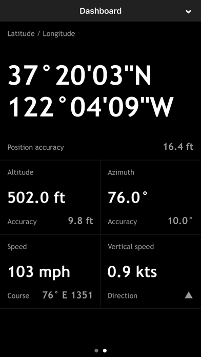
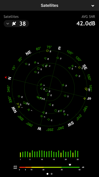
- Added two new info tools accessible via the satellite button at the lower left of the main screen:
1) Satellites - a celestial map showing computed positions of major GPS/GNSS satellites in the sky above you
2) Dashboard - all sensor data presented in a convenient large number display
- Bug fixes
- Under the hood improvements preparing the app for future updates
- New Thunderforest Maps
- UI fixes
- Navigation improvements
- Easier map selection
- OSD coloring options
New onboarding screen
UI improvements
Rotation fixes
Automatic coordinates lookup is now configurable
- Added the haptic feedback for compass
- Added a precise location check to avoid positioning issues
- UI improvements
- Improved localizations
- Improved coordinates processing for Southern Hemisphere
- iOS 14.2 enhanced support
- Night mode color themes for Google Maps
- Bug fixes
v.3.9.12:
- Fixed a bug preventing a keyboard input
- Updated Google Earth link sharing format
v.3.9.11:
- Improved layout and font sizes for the main screen
- Support for latest iOS versions and new devices
- Lots of minor bug fixes
- Improved layout and font sizes for the main screen
- Support for latest iOS versions and new devices
- Lots of minor bug fixes
○ better display of vertical speed on ascent/descent
○ performance and stability improvements
○ performance and stability improvements
○ app name is now more euphonious - Commander Compass Go
○ improved compatibility with iPhone X, iPhone 8, iPhone 8 Plus
○ added Sigma Octantis (σ Octantis, south pole star) into built-in star catalog
○ stability and performance improvements
○ improved coordinate parser
○ OSM maps optimized for high-resolution displays
○ improved recognition of coordinates
· recognition of non-standard minute (′) and second (″) symbols
· recognition of Geo Caching coordinates with a minute sign omitted
○ stability and compatibility improvements
In the app settings, you can now select a retina-optimized map source “OSM @ Happymagenta”.
Improved recognition of coordinate input allows you now to copy and paste, or type in coordinates in a more convenient way. Non-standard symbols that can be used to indicate minutes and seconds of a degree will now be properly interpreted.
Additionally, you can now copy and paste, or type in coordinates with minute and second symbols omitted when the degree symbol is present:
N 37° 41.501 W 97° 20.282 will be recognized as N 37° 41.501' W 97° 20.282'
N 37° 41 30.06 W 97° 20 16.92 will be recognized as N 37° 41' 30.06" W 97° 20' 16.92"
· compatible with latest iOS and new devices
· sub-meter GPS accuracy
· improved detection of coordinates in copied text
· improved resolution of taken screenshots
· lots of smaller improvements and bug fixes
Sub-meter, sub-foot, sub-yard, 5-digit accuracy kilometers and miles are now available as short distance units in the app settings. Smaller units are now only used for short distances while higher precision kilometers and miles are also used for long distances. Send us your thoughts if you have an external sub-meter GPS and want this feature improved further.
If you've noticed a bug or have some troubles with setting up the app, please contact us via the support form on our web site.
v.3.7.9 improves UI orientation on iPad in landscape mode
v.3.7.5 improves compatibility with iOS 8 and new devices (read full details):
- better compatibility with iOS 8 and iPhone 6, iPhone 6 Plus
- 64-bit support and major code cleanup in preparation for bigger updates
- lots of improvements and bug fixes, including:
· smoother transition between 3D and 2D compass operation modes
· improved gyrocompass mode (see details below)
· gyrocompass adjustment retained in background on devices w/o compass
· improved location access settings handling
· improved detection of long tap on the main screen
· improved user interface orientation handling
· landscape face up orientation support
· improved editing, text input and keyboard handling
· support of hiding of keyboard by sliding
· full support of native screen resolutions of new devices
· new icons optimized for new iOS and new devices
· fixed inverted sign of magnetic declination display
· fixed crash-alike behavior when app was closed and then shortly opened
· fixed crash that might happen because of lots of waypoints on a map
· fixed parsing of GEO: links with uppercase scheme part
· fixed hemisphere sign for longitudes on text format export
IMPROVED GYROCOMPASS MODE
The gyrocompass mode can now be used as a primary mode. Now in the gyrocompass mode the magnetic sensor is referenced continuously until a manual adjustment to the heading is made using the two finger sliding gesture. Unless the manual adjustment is in effect the app acts as a gyro-assisted magnetic compass.
If you've noticed a bug or have some troubles with setting up the app, please contact us via support form on our website.
v.3.7.7 fixes GPS issue on iOS prior to 8
v.3.7.5 improves compatibility with iOS 8 and new devices (read full details):
- better compatibility with iOS 8 and iPhone 6, iPhone 6 Plus
- 64-bit support and major code cleanup in preparation for bigger updates
- lots of improvements and bug fixes, including:
· smoother transition between 3D and 2D compass operation modes
· improved gyrocompass mode (see details below)
· gyrocompass adjustment retained in background on devices w/o compass
· improved location access settings handling
· improved detection of long tap on the main screen
· improved user interface orientation handling
· landscape face up orientation support
· improved editing, text input and keyboard handling
· support of hiding of keyboard by sliding
· full support of native screen resolutions of new devices
· new icons optimized for new iOS and new devices
· fixed inverted sign of magnetic declination display
· fixed crash-alike behavior when app was closed and then shortly opened
· fixed crash that might happen because of lots of waypoints on a map
· fixed parsing of GEO: links with uppercase scheme part
· fixed hemisphere sign for longitudes on text format export
IMPROVED GYROCOMPASS MODE
The gyrocompass mode can now be used as a primary mode. Now in the gyrocompass mode the magnetic sensor is referenced continuously until a manual adjustment to the heading is made using the two finger sliding gesture. Unless the manual adjustment is in effect the app acts as a gyro-assisted magnetic compass.
If you've noticed a bug or have some troubles with setting up the app, please contact us via support form on our website.
If you find Commander Compass useful, please help us spread the word by leaving a review in the App Store. In case you've reviewed a previous version of Commander Compass please resubmit it as ratings reset with each new update. It's very important as it allows us to continually improve the experience and helps other users decide whether the app is right for them. Thanks a lot for your support!
v.3.7.1:
- fixed performance on iPhone 4, iPad 1, iPod 4 and lowered CPU usage by 30-35%
v.3.7:
- vertical speed indicator:
· 5-second estimation of vertical movement speed
· appears near the altitude readings for vertical speeds faster than 80fpm (0.4m/s)
· supports knots, feet per minute, feet per second and meters per second
- smooth GPS position and course:
· smooth position and course updates
· automatically turns on for speeds over 0.5mph (1km/h)
· no more annoying jumping over maps when moving
- improved gyrocompass mode:
· profound compass calibration for the pure gyroscope mode
· warm-up time for magnetic sensor increased up to 1.5 minutes to achieve even higher precision
· manual gyrocompass calibration stops the warm-up
- font size for azimuth and altitude readings auto-increases for speeds over 1km/h
- import/export your waypoints via email
· send and receive your waypoints via email
· send waypoints as .spyglass, .kml and .gpx file attachments
· tapping the files in the email will automatically open them in the app
- import/export your waypoints via iTunes file sharing
· save/load waypoint data files via iTunes
· save waypoints into .spyglass, .txt, .kml and .gpx files
· load waypoints from .spyglass, .txt, .xml, .kml, .gpx and .gml files
- maps won't automatically turn off when going offline anymore
- a few more map layers added
- copying and pasting waypoints now includes altitude
- missing ±D.x coordinate format added
- increased D.x coordinate format precision
- improved parsing of coordinates and map links
- fixed OSNG/OSGB parsing for coordinates with fewer than 5 digits
- improved lightweight rendering:
· all the vector and text drawing cached into textures
· GPU usage lowered by 30-60%
· CPU usage lowered by 25-50%
- improved RAM usage:
· smarter memory caching under low memory conditions
- new draft user guide published on our website:
· click "(i)" button and choose "Guide" to open the download page
- corrections in all language localizations
- minor UI tweaks and bug fixes
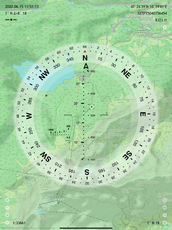
- Topographic terrain map layer added
- Switch between alternate map sources
- Improved support for iOS 7.0+ and 6.1+
- Slight user interface facelift for iOS 7
- Improved performance for iPad, especially when maps are on
- Slight performance gain for all iOS devices
- Minor bug fixes