FireMapper

FireMapper


$22.99

1.258for iPhone, iPad and more
Fire Front Solutions Pty Ltd
Developer
33.9 MB
Size
May 12, 2023
Update Date
Navigation
Category
4+
Age Rating
Age Rating
4+
Apps in this category do not contain restricted content.
9+
Apps in this category may contain mild or occasional cartoon, fantasy or real-life violence, as well as occasional or mild adult, sexually suggestive or horrifying content and may not be suitable for children under 9 years of age.
12+
Apps in this category may contain occasional mild indecent language, frequent or intense cartoon or real-life violence, minor or occasional adult or sexually suggestive material, and simulated gambling, and may be for children under 12 years of age.
17+
You must be at least 17 years old to access this App.
Apps in this category may contain frequent and intense offensive language; Frequent and intense cartoon, fantasy or realistic violence: frequent and intense adult, scary and sexually suggestive subjects: as well as sexual content, nudity, tobacco, alcohol and drugs, may not be suitable for children under 17 years of age.
FireMapper Screenshots
FireMapper posterFireMapper posterFireMapper posterFireMapper posterFireMapper posterFireMapper posterFireMapper poster
FireMapper posterFireMapper posterFireMapper posterFireMapper posterFireMapper posterFireMapper posterFireMapper posterFireMapper poster

About FireMapper

FireMapper is designed for firefighters for quickly generating bushfire and other incident maps. The applications provides a simple interface for drawing maps and exporting via Email.

Maps are stored on the local device and can be created or used offline. No internet connection is required for collecting data.

FACEBOOK & SUPPORT:
Like us on Facebook to be notified of future updates and developments.
http://www.facebook.com/FireMapperApp
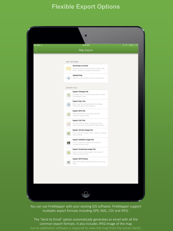
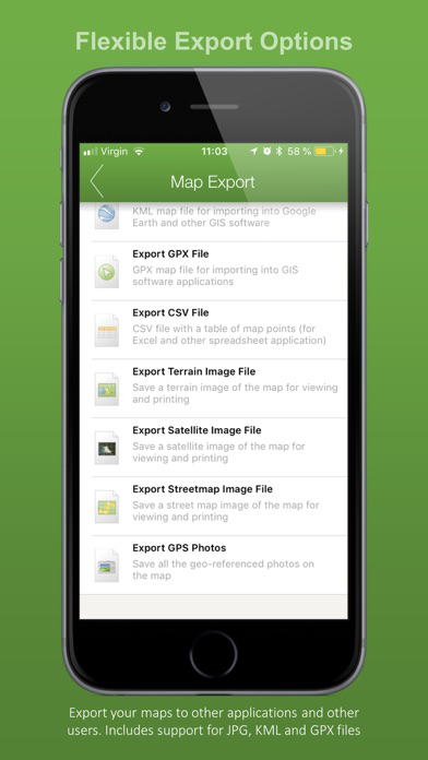
MAP EXPORT FORMATS:
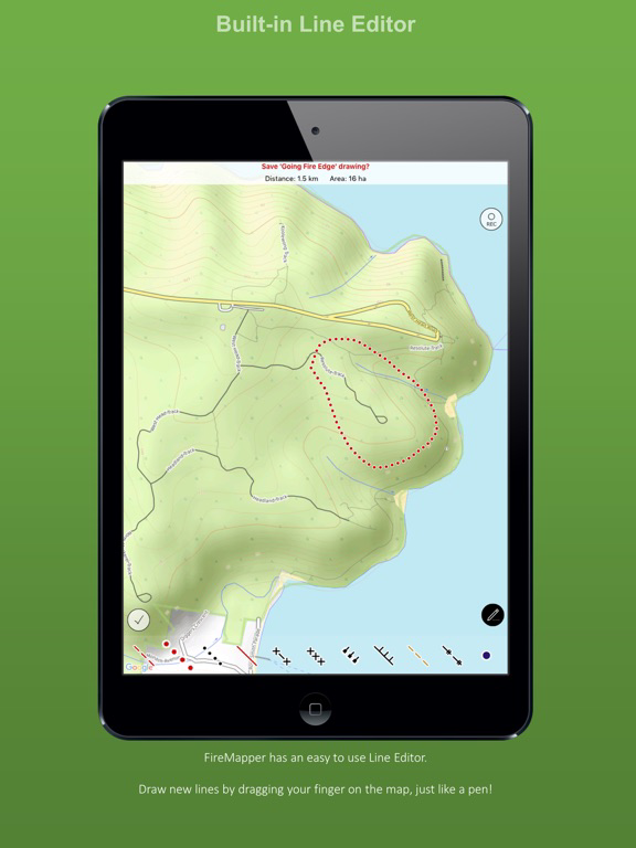
Multiple points can be drawn on the map and exported in the same email. The map data can be exported as:

* GPX (suitable for ArcGIS, MapDesk and other popular GIS products, QGIS)
* KML (suitable for Google Maps & Google Earth)
* CSV (suitable for Microsoft Excel & Google Spreadsheets)
* JPG (photo of the map)

You can also send points & lines as a text message.

GPS CAMERA:
Take geo-referenced photos and display the location and bearing on the map.
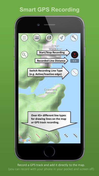
GPS RECORDING:
FireMapper supports GPS recording in the background. Continued use of GPS running in the background can dramatically decrease battery life.
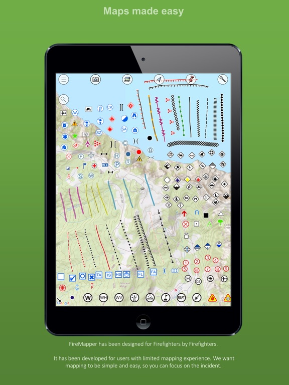
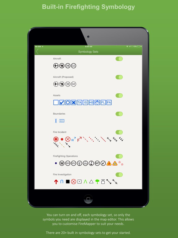
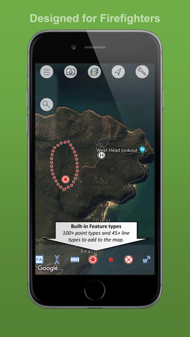
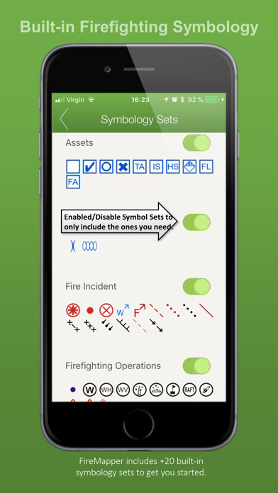
BUSHFIRE SYMBOLS:
This version contains bush firefighting symbols that are commonly used in Australia, USA & Canada with support for:
* National All Hazards Symbology Set
* USA Interagency Wildfire Point Symbols

Including the following icons:
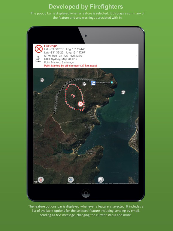
Hydrant, Water Point, Fire Origin, Spot Fire, Aerial Ignition, Hotspot, Defendable/Not Defendable Asset, Threatened Asset, Indigenous Site, Historic Site, Hazmat,Flora/Fauna, Airbase, Helibase, Helibase,Smoker Standing/Down,Tree Down, Medical, Mobile Weather Station, Portable Communications, Access Point, Control Point, Road Closure, RAFT, Drop Zone, Assembly area, Staging area, Base camp, Control Centre, Divisonal/Sector Command, Evacuation Area/Center, Escape Route, Refuge area, Property damage and more....
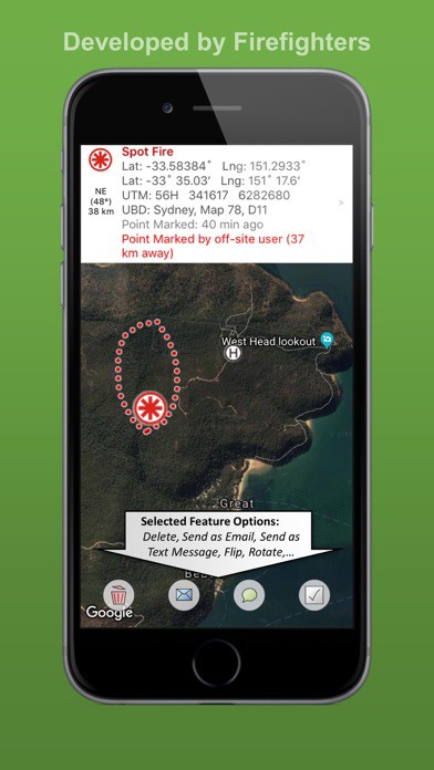
LOCATION FORMATS:
-Latitude/Longitude (Decimal Degrees and Degree Minutes/Aviation)
- UTM Coordinates
- 1:25 000, 1:50 000 & 1:100 000 map sheet references
- UBD Map References (Sydney, Canberra, Adelaide, Perth)

INTEGRATED SEARCH:
Search by address, suburb, latitude/longitude, utm coordinates, grid references, place name, point type and more.

OFFLINE SUPPORT:
Maps can be created offline without an internet connection. Map layers are cached for offline support

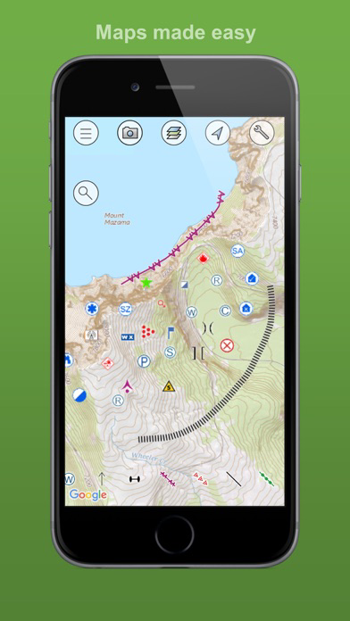
MULTIPLE MAP LAYERS:
- Standard
- Satellite/Hybrid
- Terrain/Topographic
- US Topographic
- Australian Topographic
- NZ Topographic
and more....
Show More

What's New in the Latest Version 1.258

Last updated on May 12, 2023
Old Versions
-> drop down menu on the main menu
Show More
Version History
1.258
May 12, 2023
-> drop down menu on the main menu
1.256
Nov 19, 2022
-> camera improvements
-> new layer sidebar
1.250
Oct 14, 2022
* support for importing geopdfs generated by FireWatch Pro/Landgate website.
* support for importing geospatial pdfs generated by ArcGIS Pro (with PDF compression). This allows users to import GeoPDFs that are commonly used by NIFC/Cal Fire.
* An error message is now displayed if an imported pdf has a map projection that is not supported by FireMapper.
* Added new USA ICS symbols (NWCG Standard Geospatial Operations). This includes all the new USA symbology for 2022.
* Updated PDF manual in the iOS app. This manual is included in the app so it is available offline (with no internet connection).
* Added a link on the main menu of the app to the new FireMapper Support Hub (docs.firemapper.app) for downloading manuals, user guides and more.
* Improved performance when switching between different base layers, especially over slower internet connections.
* Fixes for Quebec Romer Grid Searches
* Added support for easting/northing searches
1.241
Jul 28, 2022
-> added USA symbols
-> added search and rescue types
-> added photo features to CSV exports
1.238
Jun 11, 2022
-> added fix to extents button
1.237
Jun 6, 2022
-> Added support for drawing areas-> Updated UI
1.226
Mar 4, 2022
-> updated line editor
-> added ability to edit existing line
1.222
Feb 25, 2022
New Map Symbology for Hazards
1.219
Feb 18, 2022
-> Fixes for KML/KMZ Export-> Foreflight/Oz Runways Integration
1.218
Jan 19, 2022
Added AFAC Tree Hazards Symbology
1.217
Jan 17, 2022
Fixed Bug with Export Map as Email
1.205
Oct 2, 2021
-> Bug Fixes
-> Cleaned up user interface
1.201
Sep 5, 2021
fixed screen cutout for iPhone 11
1.198
Aug 27, 2021
-> Updated user interface for point and line editor
-> Removed FireMap file format.
-> updated sector boundary icon
1.196
Aug 20, 2021
-> Bug fixes
-> Updated Config System
1.187
Feb 16, 2021
Bug Fixes
1.184
Jan 8, 2021
-> bug fixes
-> usa line symbology
-> navigate to support
-> improvements for offline maps
1.160
Jul 1, 2020
bug fix for deleted maps
1.152
Jun 15, 2020
-> bug fixes-> improved status messages for sync layers
1.146
May 19, 2020
->Track Sharing Changes
-> GDL90 Support
1.143
Apr 22, 2020
bug fixes
1.142
Apr 16, 2020
bug fixes
1.135
Feb 24, 2020
- added map preview and photo preview to feature info screen.
- cleaned up UI
- bug fixes
1.128
Jan 18, 2020
-bug fixes
1.127
Jan 17, 2020
- fixed bug with first name, last name and role when uploading

FireMapper FAQ

Click here to learn how to download FireMapper in restricted country or region.
Check the following list to see the minimum requirements of FireMapper.
iPhone
Requires iOS 12.0 or later.
iPad
Requires iPadOS 12.0 or later.
iPod touch
Requires iOS 12.0 or later.
FireMapper supports English

FireMapper Alternative

You May Also Like

Get more from Fire Front Solutions Pty Ltd