Lake Wakatipu (New Zealand)

Lake Wakatipu (New Zealand)


Raster Nautical Charts


$0.99

3.5for iPhone, iPad and more
Vishwam B
Developer
69.9 MB
Size
Apr 14, 2020
Update Date
Navigation
Category
4+
Age Rating
Age Rating
4+
Apps in this category do not contain restricted content.
9+
Apps in this category may contain mild or occasional cartoon, fantasy or real-life violence, as well as occasional or mild adult, sexually suggestive or horrifying content and may not be suitable for children under 9 years of age.
12+
Apps in this category may contain occasional mild indecent language, frequent or intense cartoon or real-life violence, minor or occasional adult or sexually suggestive material, and simulated gambling, and may be for children under 12 years of age.
17+
You must be at least 17 years old to access this App.
Apps in this category may contain frequent and intense offensive language; Frequent and intense cartoon, fantasy or realistic violence: frequent and intense adult, scary and sexually suggestive subjects: as well as sexual content, nudity, tobacco, alcohol and drugs, may not be suitable for children under 17 years of age.
Lake Wakatipu (New Zealand) Screenshots
Lake Wakatipu (New Zealand) posterLake Wakatipu (New Zealand) posterLake Wakatipu (New Zealand) posterLake Wakatipu (New Zealand) posterLake Wakatipu (New Zealand) poster

About Lake Wakatipu (New Zealand)

COMPLETELY NEW INTERFACE & DESIGN!

THE ALL NEW UPDATED ADVANCED MARINE RASTER NAUTICAL CHARTS APP FOR BOATERS, ANGLERS, KAYAKERS, CANOER’S, FISHERMEN, WATER NAVIGATORS AND SAILORS!

NO WAITING TIME FOR NAUTICAL CHART DOWNLOADS. IT'S READY TO USE!

COMBINATION OF APPROACH, HARBOUR AND BERTHING CHARTS FOR EASY NAVIGATION.

ALL CHARTS OVERLAY IS ARRANGED IN A SEAMLESS ORDER, BASED ON CHART SCALE AND PRIORITY.

NO NEED TO CHANGE CHARTS MANUALLY, THEY ARE READY FOR CONTINUOUS NAVIGATION.


CHART FEATURES:

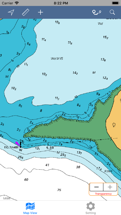
ALL MARINE RASTER NAUTICAL CHARTS ARE FROM LINZ SOURCES.

ALL CHARTS ALIGNED WITH ORIGINAL CHART CO-ORDINATES, ARE ACCURATE FOR USE.

NEW MAPS FOR OFFLINE CHART OVERLAY DISPLAY, USE THEM AS LONG AS YOU BOAT.

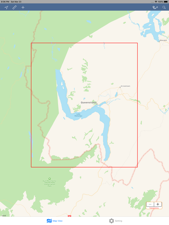
HIDE / SHOW CHART BOUNDARY.

CHART TRANSPARENCY ADJUSTMENT TO COMPARE WITH ARIEL AND STREET MAPS.


FAVORITE MARKER:

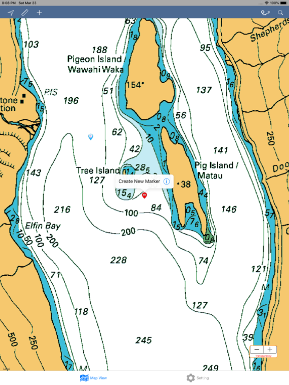
INSERT UNLIMITED FAVOURITE MARKERS ON MAP.

PHOTO TAGGED FACILITY FOR MARKERS WITH EMAIL OPTION.

ADD MULTIPLE PHOTOS TO FAVOURITE MARKERS (MAX 3 ALLOWED).

EMAIL FAVOURITE MARKERS AS KMZ FILE.


UPDATED FEATURES:

TRACK YOUR LOCATION WITH GPS ON MAP.

MEASURE LIVE DISTANCE ON CHART OVERLAY.

LONG-PRESS ON MAP TO KNOW THAT POINT CO-ORDINATE & CLOSE.


MAP DIRECTIONS:

FIND REAL-TIME DRIVING DIRECTIONS (LAND BASE ONLY). GET DISTANCE, TIME DURATION & STEP BY STEP DRIVING INSTRUCTIONS.

DIRECTION INFORMATION BUTTON WILL APPEAR UNDER DIRECTION BUTTON ONCE ROUTE IS SHOWN ON MAP. CLICK IT FOR DETAILS.

INDIVIDUAL ROUTE STEP IS VISIBLE IN DIFFERENT COLOUR WHEN DIRECTION STEP DETAILS ARE CLICKED.

THIS FEATURE WORKS ON NETWORK CONNECTIVITY.


MAP SEARCH:

SEARCH NEARBY POINT OF INTERESTS/PLACES OF YOUR REQUIREMENT.

USER EXACT KEYWORDS FOR FAST RESULTS.

ONLY TOP RESULTS ARE SHOWN BASED ON AVAILABILITY.

THIS FEATURE WORKS ON NETWORK CONNECTIVITY.


SETTINGS:

> HIDE / SHOW CHART BOUNDS.
> HIDE / SHOW CHART DISPLAY (TRANSPARENCY ONLY).
> MANAGE MAP DISTANCE & DIRECTION UNITS.
> MAP TYPE DISPLAY UPDATION.
> HIDE / SHOW MARKERS WHENEVER REQUIRED.
> RUN-TIME SETTING CHANGES WILL NOT APPLY INSTANTLY FOR DIRECTIONS AND MAP DISTANCE MEASUREMENT.


THIS APP IS MOST ADVANCED WITH ALL THE NECESSARY TOOLS FOR EASY NAVIGATION ON WATER. CONTINUOUS CHARTS DISPLAY MAKES IT MORE EASIER FOR SAILING AND AS THERE WILL BE NO INTERNET WHILE SAILING, THE OFFLINE CHART MODE IS FASTER FOR NAVIGATION.

NOTE: All charts are Geo-positioned to match the exact location of features displayed on charts but there may be some difference between the positions of actual objects that are in the water or sea and charts because of the different chart scales.

Disclaimer: The offline Raster Nautical Charts data provided in all charts is from LINZ and is for reference purposes only and not for navigation.

We are experts in GIS & IOS Apps development and strive to provide the best products to the customers. Any suggestions from the users of this product are welcome to make the app more useful.


HAPPY BOATING AND SAILING VOYAGES ALL THE TIME!
Show More

What's New in the Latest Version 3.5

Last updated on Apr 14, 2020
Old Versions
Nautical charts clearer than before.
Compatible to iOS 13 and new devices.
Show More
Version History
3.5
Apr 14, 2020
Nautical charts clearer than before.
Compatible to iOS 13 and new devices.
3.0
Mar 24, 2019
1. Now supports to iPhone X, iPhone XS, iPhone XR, iPhone XS Max, iPad Pro 11 inch & iPad Pro 12.9 (3rd generation).
2. iOS 12 Compatibility & Completely New Feature Interface and Design.
3. Updated User-Interface for Faster use.
4. Add Multiple Photos to Markers (Max. 3 allowed per Marker).
5. Edit Marker Content and Photos any time.
6. Email Markers as KMZ format.
7. On-Land Map Points Search.
8. On-Land Direction Finder to Lake or between any Custom Locations.
9. Map Co-ordinate Info. Works on Long Press & can be Removed if not required.
10. Map Boundary ON/OFF adjustment.
11. Distance Measurement between 2 points.
12. New Map Settings updated for convenient usage.
1.0
Aug 1, 2016
This update is signed with Apple’s latest signing certificate. No new features are included.

Lake Wakatipu (New Zealand) FAQ

Click here to learn how to download Lake Wakatipu (New Zealand) in restricted country or region.
Check the following list to see the minimum requirements of Lake Wakatipu (New Zealand).
iPhone
Requires iOS 10.0 or later.
iPad
Requires iPadOS 10.0 or later.
iPod touch
Requires iOS 10.0 or later.
Lake Wakatipu (New Zealand) supports English

Lake Wakatipu (New Zealand) Alternative

You May Also Like

Get more from Vishwam B