Fixes for iOS17
Major
- Fixed the Audio bug that stopped audio navigation after a short time
Minor
- Fixed some MENU label issues
- Some other basic interface fixes
Some fixes reported by our operators in the field
- Fixed issues with the UTM coordinate format and made it easier to enter in those coordinates
- Minor bug fixes
We appreciate your feedback so please take the time and give us a review!
Some tweaks and fixes
- Added Done button to iPad settings screen to support iOS 12 and lower not allowing you to exit Settings
- Fixed an issue where the settings page was changing sizes
- Updated the purchasing process where it was having some random issues with verification
- Updated the Restore button to work with our new server
Thank you for all the support and letting us know how we are doing, Please give us a review!
Some slight upkeep and tweaks as we head into off-road season
- Improvements to subscription handling and interface
- Minor bug fixes
- Fixed purchase screen graphics and text
If you enjoy LEADNAV, please tag us on social media and leave a review!
Some slight upkeep and tweaks as we head into off-road season
- Improvements to subscription handling and interface
- Minor bug fixes
If you enjoy LEADNAV, please tag us on social media and leave a review!
Continuing to update and overhaul our subscription handling through Apple
- Minor fixes to the Restore purchase button for some instances where a current subscriber activates a new device
Thank you for supporting with your feedback!
You definitely want this update!
Major Bug Fixes
- Last week we pushed a total overhaul to the subscription handling...unfortunately a few switches got flipped and things turned off. This made some Pro features not available to new users. Sorry...things happen but we appreciate those supporting us and letting us know!
Features
- They are all back
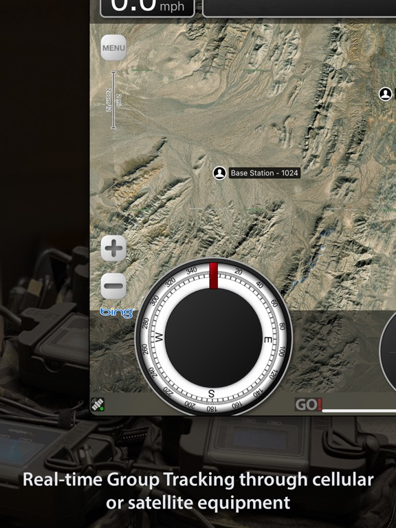
We spent the past few months rebuilding subscription handling to include now offering our Satellite Group Tracking as an In-App monthly or yearly activation to use with Iridium GO! units and the separate Iridium unlimited services.
Lots of capability added with that for offline, peer to peer group tracking. If you don't know what this is...don't buy it till you learn more from our website and have the hardware to run it.
Features
- Added our Satellite Group Tracking subscriptions to be now purchased In-App!
- You also get per month pricing available as well as the traditional year pricing
Not only does this free up our need to activate each and every device, but in turn it drops the cost across a number of Iridium devices sharing the same Group/Team iTunes account.
**NOTE if you do not know what this is...you probably don't know how to use it nor have the satellite Iridium packages to actually run it. So, DO NOT PURCHASE IT until you learn more from our website. This is a service allowing you to see each other in the field in areas without traditional cellular or WiFi coverage. To do this, it requires satellite equipment and SERVICE. The only service we recommend is the Iridium GO! Unlimited plan, as anything else will burn out your data too quickly. Make sure you get that equipment and service lined up first.
Terms apply as per website and we are not responsible for you not knowing how to use it after you purchase it. Most of our folks running this have been trained by us, in person, through our courses...or they happen to be computer geeks... In our experience, most desert racers AREN'T "computer geeks" (no offense)...so grab your kid or an IT person before purchasing.
***Also these are large auto renewing subscriptions...so remember to cancel prior to your next billing cycle if you do not wish to continue.
Bug Fixes
- Killed one that appeared recently where in certain instances GPX files were not able to import
- Also, we hopefully killed a bug that showed new users that they had a Pro Pack subscription when they actually had not purchased one...bear with us as we just did a major overhaul to subscription handling
As always, THANK YOU....and let us know if you like the app by giving us a review!
Cleanup and updates to In-App Subscriptions and handling
- Advanced and Pro upgraded to auto-renewing!
- Able to utilize Apple's better handling of subscriptions and promotions
- Better over view of our subscriptions
Remember to visit our new website and training page!
Join our newsletter and You Tube channel.
Minor cleanup and updates
- Eliminated the email entry in the core app for our non Enterprise customers. All subscription handling is done by Apple In-App
- Relinked the Privacy Policy and Tutorials In-App to the new updated website
Maps
- Phasing out MapBox for ESRI you can download ESRI World Imagery for offline use instead of MapBox satellite
Remember to visit our new website and training page!
Join our newsletter and You Tube channel.
Minor Bug fixes
- Stopped app from crashing when running cellular "on grid" tracking when in areas with weak to no cell service
- Minor description and text updates
- Made the Merging Route stacking bars brighter in the MENU list
This is a minor update as some of our users get ready for the Baja 1000 desert race.
MapBox Satellite will be getting phased out so we recommend switching over to using ESRI World Imagery instead or a custom map URL of your choosing
Thank you and please give us a review!
Bug fix
- As we made MBTile Overlays available to both Pro and Advanced subscriptions...something broke (Oops)...we fixed it!
- Some small verbiage changes
Please Review and use our You Tube channel and Community Forum to learn and share.
Thank you!
LEADNAV 6.5 is here as we continue to work with our map providers (new and old) to offer you the best background map imagery we can provide. We are also rolling some highly requested Pro features down to our Advanced subscribers.
Features
- ESRI map imagery is here with Satellite, Terrain and Street available for offline prep for your next trip “off the grid”
- Overlay / MBTile use has been bumped down from Pro and made available to our Advanced subscribers
Fixes
- Multiple bugs taken care of to include the new iPhone HUD display issues on certain smaller devices
- Performance updates
Note
- Offline map imagery is offered through our outside providers and subject to changes they make to the terms of use and pricing. As we continue to work with these companies to provide the very best background mapping we can for our users, understand that this map imagery is intended to be saved and prepped per trip, used and deleted before going on your next trip, borrowing this imagery, versus storing indefinitely.
However, there are even more advanced ways to prep and plan for your trips, subscribe to our You Tube channel and join our Community Forum to learn more!
Remember to give us a review!
LEADNAV 6.0 is here!
Big release for the iPhone.
Updates
- The iPad HUD has made its way onto the iPhone! Complete overhaul... This preps the framework for what you all have requested and yes, the iPhone Landscape view is up next.
Remember to give us an App review with every update!
Thank you and keep navigating forward
This is a quick-turn bug fix release.
Due to a change in recent versions of iOS, some users were unable to purchase, extend, or renew their subscriptions via In-App Purchase. Other methods were not affected. This release fixes the issue.
- In App Purchases fixed within iOS updates
Thank you and remember to give us a review and follow our new You Tube channel, Newsletter and become part of our community forum.
Bug Fixes
- Crashes in some later iOS versions after the last update when viewing items from prior Collections
New Year and new features on the way!
Remember to give us a review and thank you for using LEADNAV!!!
Changes:
* Increase tracking update rate, Iridium network is improved
* Enable Markers for ProPack subscribers
* Update default Track name format
Fixes:
* Fix inconsistent Waypoint dropper to 0.0º, 0.0º when in PreRunner (No more spiderwebbing in PreRunner! Desert Racers, let us know how this performs!)
* Fix 'Delete Selected' wasn't deleting all selected
* Fix Map popup cutoff of bottom edge
* Fix readability with Light/Dark mode in iOS13
* Fix search case-sensitivity and auto-capitalization
* Fix MGRS compiler antics
* Properly format distances > 100km
* Fix Magenta flashing loupe
* Fix waivering route length when zooming in and out
Performance improvements and bug fixes:
* Stabilized Magnification Loupe
* Improved route distance calculation
* Fix rare UI pause within Settings
Smoother experience for iOS13
- Small bug fixes
- Performance improvements
Ready for iOS13! Otherwise, small bug fixes and performance improvements
This release has been in the works for a very long time and it is finally here!
You can now get subscriptions from us and through our Tier Operators
- Upgraded purchasing and handling of In-App Subscriptions
- Minor Bug fixes and stability improvements
This release has been in the works for a very long time and it is finally here!
You can now get subscriptions from us and through our Tier Operators
- Upgraded purchasing and handling of In-App Subscriptions
- Minor Bug fixes and stability improvements
Updates
- GPS positioning improvements
Bug Fixes
- Eliminated "ghost dotting" with multiple position dots and improved the position dot usage
- Eliminated an issue where you would have no position dot when occasionally starting up LEADNAV
Remember to give us a review in the App Store with every update!
Thank you!
LEADNAV
Streamlining LEADNAV and our pricing models while greatly improving the purchasing process!
New In-App Subscription model
- The Core LEADNAV GPS application (one time purchase)
Off the Grid focused, GPS interface for planning and navigating
- Advanced Pack (1 Year)
General upgrade with offline map imagery for those primarily on foot covering less ground while off the grid
- Pro Pack (1 Year)
Professional features and the ability to save and store larger areas of offline background map imagery for those operating from mobility platforms going into dismounted foot patrol operations.
*Desert Racing and more advanced Route building tools and capabilities.
*Off the Grid - Group tracking with our additional satellite equipment and service plans
Updates
- Basic Map Subscription removed
*With this update all of our Basic Map Subscription users will get upgraded to Advanced Pack
- Improved the In-App process to limit errors in the subscription purchasing
- Improved reflecting In-App purchases across your multiple devices
- Bumped some In-App features to the core LEADNAV GPS application
- Cleaned up the Settings and descriptions
- Tuned the external XGPS160 bluetooth antenna interaction
Remember to give us a new App Store review with this update! We appreciate your feedback and support!
Getting back into the code!
Minor bug fixes and stability improvements,
Specifically:
* Ghost dots are gone
* Voice status updates are fixed
- Setting to zero disables updates
- No more repetition
* Clear All button in route editor is disabled (for your safety...more to come)
* Iridium phone number entry gracefully handles '+' or absence of '+'
* Various screen rendering updated for new iPads, iPhones and Watches
* Unneeded Compass Calibration is removed
Remember to give us an App Review with every update!
Visit our Community Forum and our new Training Section!