Think GPS Device Data, Combined with Maps.
LocationPRO is a Multifunctional Advanced Location Data and Navigation Application for iOS. Works with both iPhone and iPad.
What can I use it for?
- Cyclist wanting to see how fast they can go
- Driving a known route but want to be able to see the road without an annoying sat nav
- Saving locations as pins to make a personal map
- Finding latitude and longitude coordinates for the emergency services
- Lost and need to know which town or city you are in
- Need to draw a route on a map for a friend
The list of possible uses is endless, LocationPRO is there when you need it, try it today!
LocationPRO is simple to use and has a wide array of features that everyone can find useful.
See a video demo at http://locationpro.jonathanfield.me/locationpro.html
For Guides, How-To's and Support http://locationpro.jonathanfield.me
Feel free to request new features or help at
http://locationpro.jonathanfield.me/support.html
Data Displays:
Course display
Direction display
Altitude Display
Speed Display
Export photo to Twitter with your current location
- Take a photo and post it to twitter along with a prepared tweet containing your current geocoded location
Export map to twitter with current location
-Tweet a prepared tweet of your current location and a picture of your current map
Export map via email - attached link to Google Map location and advanced Location Data
Export advanced location via SMS/ iMessage - Send people details of your location e.g. latitude, longitude, altitude, speed, course, date and time.
Set a pre-prepared emergency message and set contacts for it to be sent to along with advanced location data in the event that you are lost and need help.
Distance travelled display
- Enable distance display to see how far away you are from your starting position
- Please note this setting assumes you are moving away from your starting location
Rotate map with compass heading
- See the map at the same angle that you see whats ahead of you
Dedicated speedview
-Fullscreen speed display in MPH and KPH
On the fly map style change
-Standard
-Satellite
-Hybrid
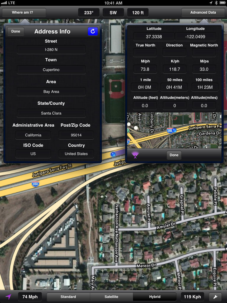
Geolocation data, find out exactly where you are in the world
-Street
-Town
-Area
-State/County
-Administrative Area
-Postal/Zip Code
-ISO Country Code
-Country
Advanced location data, when you need more precise location information
-Latitude
-Longitude
-True North
-Direction North, East, South, West
-Magnetic North
-Current Speed in MPH, KPH and MPS
-Calculated time to travel 1,50 and 100 miles
-Altitude in feet, meters and miles
-Small map of your current location
Pin drop data
-Display the address information for any location on the map with a simple pin drop
-Display advanced location information for any location (as much as is available)
-Display the distance of the pin from your current position
-Save and name pins
-Street
-Town
-City/County
-Administrative Area/State
-Postal/Zip Code
-Latitude
-Longitude
-Distance from current location
iCloud or device stored custom map
-Name and save pin locations for future reference, for instance where you are parked or location of an item in a store
-Enable iCloud data and document storage to save pins between iOS devices
-If iCloud is not enable your pins will be saved to your iPhone or iPad
-Reset your pins from the menu
Drawing view
-Draw on the map with your finger
-Draw directions on the map and then export to Twitter, Email, Photo Album or Print via AirPrint
Breadcrumb trail
- Enable breadcrumb to draw a line as you travel.
- Export the map with your trail and show your friends exactly how to get to you
Export to saved photo album
Print map via AirPrint
Please note
- iPad 3G required to take advantage of dynamic location updates such as speed.
- 3G data connection required for maxmium performance but still accurate with 2G
- LocationPRO does use cellular data for advanced location data.