London Tube by Zuti

London Tube by Zuti


Geographical London Tube Map


Free

5.5for iPhone, iPad and more
9.9
3 Ratings
Visual IT Ltd
Developer
90.7 MB
Size
Nov 30, 2019
Update Date
Travel
Category
4+
Age Rating
Age Rating
4+
Apps in this category do not contain restricted content.
9+
Apps in this category may contain mild or occasional cartoon, fantasy or real-life violence, as well as occasional or mild adult, sexually suggestive or horrifying content and may not be suitable for children under 9 years of age.
12+
Apps in this category may contain occasional mild indecent language, frequent or intense cartoon or real-life violence, minor or occasional adult or sexually suggestive material, and simulated gambling, and may be for children under 12 years of age.
17+
You must be at least 17 years old to access this App.
Apps in this category may contain frequent and intense offensive language; Frequent and intense cartoon, fantasy or realistic violence: frequent and intense adult, scary and sexually suggestive subjects: as well as sexual content, nudity, tobacco, alcohol and drugs, may not be suitable for children under 17 years of age.
London Tube by Zuti Screenshots
London Tube by Zuti posterLondon Tube by Zuti posterLondon Tube by Zuti posterLondon Tube by Zuti posterLondon Tube by Zuti poster
London Tube by Zuti posterLondon Tube by Zuti posterLondon Tube by Zuti posterLondon Tube by Zuti posterLondon Tube by Zuti posterLondon Tube by Zuti poster

About London Tube by Zuti

● TRAVEL AT NIGHT ●
● Now contains routing for the latest TFL night services.

● TRAVEL IN THE FUTURE ●
● Now with the new Elizabeth line (Crossrail) services included so you can plan a journey in the future.and see how the new services will change your journey.

● KEY FEATURES ●
● Simple, fast and easy to use
● Clear route itinerary with direction, towards and frequency of service making it easy to travel on the London Tube network like a professional.
● Designed for the first time visitor and experienced commuter.
● Unique "Travel Explorer" feature provides a view of travel times and distances from any location on the map.
● Colourful and clear transport map with geographical features and places of interest.
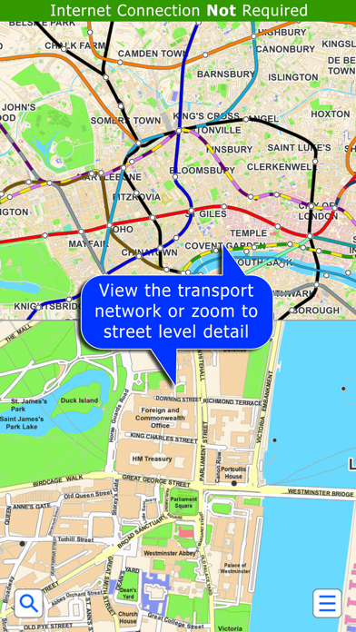
● Online street map integration (when an internet connection is available).
● Services can be turned on or off, routing around problems.
● Easily locates your nearest transport stop.
● Includes Heathrow, Stansted and Gatwick airport rail connections, Thames river boat and Croydon tram services.

● OVERVIEW ● The London Tube application is a superb professionally drawn map and route planner for the TFL London Underground system with many unique features. The inbuilt map provides a simple and colourful view of the city underground services with the ability to view an online street map when an internet connection is available. This way the user can view the street map feature when above ground and the transport map and route planning is still fully functional underground or anywhere there is no internet connectivity. This provides the best of both worlds, the transport map and route planning anytime, anywhere and online street maps and search when a connection is available.

● ROUTING ● Does not require an internet connection and will always be available to display a clear and detailed view of the city transport system, plus list and animate the optimum route for your journey. Provides the fastest route calculations of any mobile routing application (virtually instantaneous) using actual published journey times with the ability to select the quickest route or the route with the least changes.
Comprehensive details of your planned route are provided, including changes, directions of travel, number of stops, predicted journey times, etc. Uniquely this application gives you “direction”, “towards” and “service frequency” information (not available on any other offline journey planner) for example “Take the Northern line (Southbound) towards Stockwell for 10 mins (6 stops). Service runs every 7 minutes” which is essential when finding the correct platform and connection. Also given are alternatives for each leg of the journey.

● NO INTERNET CONNECTION REQUIRED ● The map and routing do not require an internet connection and you will not be charged data connection fees. This also means the application runs perfectly underground, on an aeroplane, etc. For international visitors to a city who have data roaming turned off this is an ideal solution.

● LIVE INFO ● When an internet connection is available, optional "Live Information" on the current state of the transport services and real time station departure boards can be viewed allowing you to plan your journeys in advance and avoid any potential delays.

● MORE MAPS ● This map is one in a series of Zuti worldwide city maps, if you like this product you may also enjoy some of our other offerings, please visit www.zuti.co.uk for further information.
Show More

What's New in the Latest Version 5.5

Last updated on Nov 30, 2019
Old Versions
1. Bug Fixes
Show More
Version History
5.5
Nov 30, 2019
1. Bug Fixes
5.4
Nov 27, 2019
1. Updated routing. Please note there are still no Crossrail/Elizabeth line services but we have included the option to try journeys with these services so you can experience the future benefits :-)
2. Updated app and bug fixes.
5.3
Jun 7, 2019
1. Updated map and transport services
2. Improved route planner
3. Updated Travel Explorer mode
4. Additional GPS functionality
5. Additional Map Marker features
5.1
Sep 14, 2017
Just removed the old out of date screenshots
5.0
Sep 11, 2017
1. Completely new map design that now includes a detailed street map for central London.
2. Ability to show or hide the transport services.
3. New improved search with built in database for 1000’s of locations.
4. Updated routing with time zones for Day, Night and Crossrail Open or Closed.
4.4
Mar 22, 2017
1. Minor route updates
4.3
Mar 16, 2017
1. Routing and graphic updates re the following closures:
Lancaster Gate on the Central line
Custom House on the DLR line
Charing Cross on the Northern line
Shenfield on the TFL line.
2. Routing and graphic updates re the following re-openings:
Lambeth North re-opening on the Bakerloo line
London Overground services between Gospel Oak and Barking.
3. Latest routing for the TFL night services.
4.1
Oct 21, 2016
1. Night time zone added to match current TFL Night map
2. Routing and graphic updates re Holland Park reopening
3. Routing and graphic updates re Lambeth North closing
4. Routing and station updates re closure of London Overground service from Gospel oak to Barking
5. Updates to the information sections
4.0
Aug 25, 2016
Updated map and routing
3.5
Jun 22, 2016
1. Improved Travel Explorer mode
2. Updated interface
3. Latest map and routing
3.4
Nov 3, 2015
◉ New map and routing
◉ Ability to travel in the future using the new Crossrail services
◉ Improved search
3.2
Jun 7, 2015
New map and routing
Completely redesigned user interface
New map markers feature
1.3
Jan 23, 2014
New map and routing due to changes on the TFL network, namely:
1) Due to refurbishment Bakerloo and Northern trains will not stop at Embankment until early November 2014
2) Lift maintenance work at Edgware Road (Bakerloo line) station is now complete and the station has reopened
1.2
Jun 14, 2013
1. Updated map and routing (Edgware Road now closed).
2. Improved "Travel Explorer" mode.
1.1
Apr 8, 2013
Updated map and routing.
1.0
Feb 20, 2013

London Tube by Zuti FAQ

Click here to learn how to download London Tube by Zuti in restricted country or region.
Check the following list to see the minimum requirements of London Tube by Zuti.
iPhone
Requires iOS 9.0 or later.
iPad
Requires iPadOS 9.0 or later.
iPod touch
Requires iOS 9.0 or later.
London Tube by Zuti supports English, French, German, Italian, Spanish

London Tube by Zuti Alternative

You May Also Like

Get more from Visual IT Ltd