”MSI Emergency Navigation” is designed to support safe behavior and peace of mind during large-scale disasters. Not only does it guide users with routes to nearest evacuation centers, its AR function keeps users in the right direction in pitch darkness as well. It offers some continued functionality even when telecommunication systems are interrupted. It is full of convenient functions for disaster relief such as helping people gather information on, and check the welfare of loved ones.
※ MSI Emergency Navigation can only be used within Japan.
■ Overview of MSI Emergency Navigation
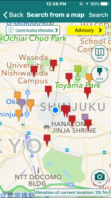
Evacuation Center Function
Press the “Search by Map” button activates the smartphone’s GPS function to get local information and display surrounding evacuation centers. It also includes the altitudes of evacuation centers in lieu of tsunamis.
The routes from the user’s location to each evacuation center are also displayed. Selecting on an evacuation center also displays its address, telephone number and other information.
Camera (AR) Function
The GPS and camera (AR function) display the direction of evacuation centers in landscape mode. Even in darkness, directions to evacuation centers is easy and comforting! Additionally, once an evacuation center data has been stored in a smartphone, the AR can still be used even if telecommunication services are interrupted. The compass can also be used.
Disaster Know-how
Under the supervision and guidance of the InterRisk Research Institute & Consulting Company of the MS&AD Insurance Group, information about what to do during an earthquake, typhoon or other large disaster is available for quick reference and peace-of-mind even if telecommunication services are interrupted.
Person Finder Registration & Confirmation Functionality
From evacuation center details screen, users can easily register with services such as Google’s “Person Finder” to help secure information on the safety and whereabouts of loved ones. Groups such as whole families that register in advance as same group members can then check on the safety of all members at the time of a disaster. To use the service, it is recommended that families or group members indicate in advance “If we get separated during a disaster, let’s register with ‘Person Finder’ and confirm our safety and whereabouts.”
■Important Items & Restrictions
1. Important Items
(1) This app was designed for use only in Japan.
(2) In the event of an actual evacuation, please respond as the situation demands, referring to local conditions and the directions of your local authorities.
(3) Evacuation center data is based on centers designated by the local governing bodies of Japan.
2. Restrictions
(1) The disaster prevention information and evacuation center name and address information provided in this app is limited to the country of Japan. Moreover, part of disaster prevention information and evacuation center name and address information is provided only in Japanese.
(2) Depending upon the telecommunication infrastructural environment, the accuracy or acquisition of current locational data may be reduced or absent.
(3) The use of GPS functionality means that the accuracy of current locational data may be reduced indoors.
(4) Because the AR function utilizes the electronic compass installed in smartphones, the influence of surrounding magnetism may be large. As a result, display accuracy may differ by environment.
(5) For evacuation center data, This Service connects to and uses servers managed and operated by 1st Media Corporation. While this data is constantly being updated, precise data at the point of use at all times is not guaranteed.
(6) The automatic save function (cache function) of evacuation center data acquired by this app may increase required smartphone data volume leading to operating constraints in the smartphone itself.