NaVida

NaVida


Maps for and by enthusiasts


FreeOffers In-App Purchases

1.6.4for iPhone, iPad and more
7.9
2 Ratings
Electronic Chart Centre
Developer
77.7 MB
Size
Mar 12, 2024
Update Date
Navigation
Category
4+
Age Rating
Age Rating
4+
Apps in this category do not contain restricted content.
9+
Apps in this category may contain mild or occasional cartoon, fantasy or real-life violence, as well as occasional or mild adult, sexually suggestive or horrifying content and may not be suitable for children under 9 years of age.
12+
Apps in this category may contain occasional mild indecent language, frequent or intense cartoon or real-life violence, minor or occasional adult or sexually suggestive material, and simulated gambling, and may be for children under 12 years of age.
17+
You must be at least 17 years old to access this App.
Apps in this category may contain frequent and intense offensive language; Frequent and intense cartoon, fantasy or realistic violence: frequent and intense adult, scary and sexually suggestive subjects: as well as sexual content, nudity, tobacco, alcohol and drugs, may not be suitable for children under 17 years of age.
NaVida Screenshots
NaVida posterNaVida posterNaVida poster
NaVida posterNaVida posterNaVida posterNaVida poster

About NaVida

One of the top free map display apps for both mobile and tablets!

NaVida is a free app ideal for anyone using maps/charts on land and sea. It contains a growing number of quality map layers, rich content and useful features.

Map layers
• OpenStreetMap - Worldwide
• Bing Aerial - Worldwide
• Topographic - Norway
• Maritime Paper Chart - Norway
• Aviation obstacles - Norway
• Nautical Electronic Chart – Norway
• AIS- a Automated Information System (AIS) map layer, which allows the user to see vessel positions in certain areas. The source feed is based on data released by aishub.net.
• S-102 shade and color.

Functionality
• Pregenerated offline archives with offline map data (in-app purchase subscription)
• Places of interest search (Nominatim & Sentralt StedsnavnRegister)
• Zoom/pan functionality for efficient navigation in the chart
• Waypoints with import/export of GPX files.
• Bookmarks.
• Display map coordinates in different formats
• Track log with import/export of GPX files.
• Import KML/KMZ files.
• Import MBTiles files.
• Edit and share map layers over iCloud with points, lines and areas.
• Measure distance via several points in map.
• Adjust safety depth and deep depth.
• Import S-102 files.

NaVida can not be used for navigation in accordance with regulations published by the International Maritime Organization.

NaVida Premium is an optional subscription that gives access to extra map layers, offline archives and extended AIS track history.

The offline archives is a way to download Topographic - Norway, Nautical Paper Chart - Norway and Aviation Obstacles - Norway for a particular region. Other map layers are not included due to legal and / or space reasons. Not all zoom levels are included due to space reasons.

NaVida Premium will be charged to your iTunes Account at confirmation of purchase.

Your account will be charged at the same price for renewal within 24 hours prior to the end of the subscription period. Your subscription will automatically renew unless auto-renewal is turned off (at least 24 hours before the end of the current period).

You can manage your subscriptions or cancel auto-renewal at any time either from the Library menu or via your Account Settings in the App Store.

NaVida is made with MapLibre Native.
Show More

What's New in the Latest Version 1.6.4

Last updated on Mar 12, 2024
Old Versions
* Fix geonorge search.
* Reduce memory usage when loading S-102 files. This fixes crashes on some devices.
Show More
Version History
1.6.4
Mar 12, 2024
* Fix geonorge search.
* Reduce memory usage when loading S-102 files. This fixes crashes on some devices.
1.6.3
Feb 25, 2024
* Show AIS category and flag state.
* Do not show old AIS targets.
* Can now add other ECC GDS/GeoView Remote Update servers.
* Better support for GeoJSON with holes.
1.6.2
Feb 5, 2024
* Fix problem with OpenStreetMap and Bing map layers for some users.
* Fix problem with measurement-label when zoomed far in.
* PRIMAR Remote Update progress bar.
1.6.1
Jan 18, 2024
* Bugfixes layer selector.
1.6.0
Jan 11, 2024
* Library -> Mariner settings -> safety/deep depth.
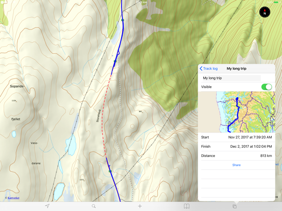
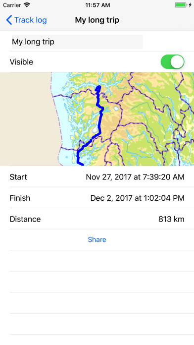
* Adjust color and transparency of track log.
* NaVida Premium: Support for S-102 with PRIMAR Remote update.
* Better place name search when selected nautical chart.
* AIS navigational status.
1.5.3
Mar 11, 2023
* Bugfix for GeoNorge service list.
* Search GeoNorge services.
* KML/KMZ improvements.
* Sweden and Finland in topo layer name.
* View Track log using Augmented Reality.
1.5.2
Jun 29, 2022
* Do not include downloaded offline archives in iCloud backup.
* Less storage use for offline archives.
1.5.1
Apr 24, 2022
* Fix startup problem for some users with a lot of offline data.
* Reduce storage used after delete of offline data.
* Prevent crash when adding Mapbox/Maplibre style URL with no 'name'.
1.5.0
Apr 19, 2022
* Nautical electronic chart with improved details and reduced clutter.
* Switched map engine from Mapbox to Maplibre.
1.4.1
Mar 14, 2022
* Fix for switching between north up and course/heading up on iPad.
* ShipSpotting changed URL format.
1.4.0
Feb 14, 2022
* Faster loading of offline archives.
* AIS vessel info showing direction/course to vessel from own position.
* AIS vessel info to show units for the values.
* Course up defaults to showing own position a bit down on the screen.
* Use compass to switch between north up and course up.
* Use magnetic heading if true heading is not available.
* WMS GetFeatureInfo to use sub layers if main layer is not queryable.
1.3.5
Oct 18, 2021
* Measure distance in map.
* Switch to new norwegian place name search API as old one stopped working.
* Show help text when adding line/polygon to iCloud layer.
1.3.4
Aug 15, 2021
* Better handling of large track logs.
1.3.3
Aug 5, 2021
* Reduce problem with AIS vessels without name.
* Fix for kml without Placemark icon.
* Fix for kml with Placemark ExtendedData.
* Fix for crash when adding Waypoint category.
* Make Waypoint editable from layer menu.
* Fix crash on startup.
1.3.2
Jun 21, 2021
* MBTiles as overlay. Can be base layer if specified in MBTiles metadata.
* Fix nautical chart feature info crash.
* Fix for ordering overlays.
* Fix for iCloud layer.
* Show error message on failed restore purchase.
1.3.1
Jun 6, 2021
* UTM coordinates both with and without zone belt.
* Fix polygon area calculation.
* Fix for problem running under iOS 10.2, 11 and 12.
1.3.0
Jun 1, 2021
* Waypoints and Bookmarks stored in iCloud.
* Create own vector map layers in iCloud with support for points, lines and polygons. Sync between devices and share with friends.
* Fix for KMZ with placemark icons inside the KMZ.
* Search in KMZ/KML.
* Keyboard shortcuts for pan/zoom.
* UTM coordinates with zone belt and properly 0-prefixed.
* Add URL can handle more layer types.
1.2.24
Nov 2, 2020
* Can open KML/KMZ file as separate map layer.
* Performance improvements.
1.2.23
Oct 17, 2020
* Bugfix layer selector.
* Performance improvements.
1.2.22
Oct 8, 2020
* Nautical Electronic Chart support feature info by long-press.
* Nautical Electronic Chart as background map switched from raster to vector.
* Performance improvements.
1.2.21
Oct 4, 2020
Performance improvements.
1.2.20
Aug 18, 2020
* Waypoint categories.
* Share multiple waypoints as GPX.
* Nautical Electronic Chart - Norway for all users.
* Prevent duplicate waypoint when opening universal link.
1.2.19
May 13, 2020
* Coordinate/waypoint share universal link for open in other NaVida or display on web map.
* AirDrop waypoint.
* Fixed bugs related to importing GPX with waypoints.
* Can read a raster MBTiles file and use it as a background layer.
1.2.18
Apr 14, 2020
* Show number of minutes instead of timestamp on course line marks.
* Bugfixes.
1.2.17
Jan 28, 2020
* Settings->NaVida->Show Course Line to turn on course line with marks for 5, 10, 30 and 60 minutes ahead.
* Bugfixes.

NaVida FAQ

Click here to learn how to download NaVida in restricted country or region.
Check the following list to see the minimum requirements of NaVida.
iPhone
Requires iOS 14.7 or later.
iPad
Requires iPadOS 14.7 or later.
iPod touch
Requires iOS 14.7 or later.
NaVida supports English, Norwegian Bokmål
NaVida contains in-app purchases. Please check the pricing plan as below:
Nautical Electronic – Norway
$3.99
NaVida Premium (1 month)
$2.99
NaVida Premium (1 year)
$19.49

NaVida Alternative

You May Also Like

Get more from Electronic Chart Centre