Ocean 3D Ionian Sea

Ocean 3D Ionian Sea


$8.99

1.1for iPhone, iPad
Age Rating
4+
Apps in this category do not contain restricted content.
9+
Apps in this category may contain mild or occasional cartoon, fantasy or real-life violence, as well as occasional or mild adult, sexually suggestive or horrifying content and may not be suitable for children under 9 years of age.
12+
Apps in this category may contain occasional mild indecent language, frequent or intense cartoon or real-life violence, minor or occasional adult or sexually suggestive material, and simulated gambling, and may be for children under 12 years of age.
17+
You must be at least 17 years old to access this App.
Apps in this category may contain frequent and intense offensive language; Frequent and intense cartoon, fantasy or realistic violence: frequent and intense adult, scary and sexually suggestive subjects: as well as sexual content, nudity, tobacco, alcohol and drugs, may not be suitable for children under 17 years of age.
Ocean 3D Ionian Sea Screenshots
Ocean 3D Ionian Sea posterOcean 3D Ionian Sea posterOcean 3D Ionian Sea posterOcean 3D Ionian Sea posterOcean 3D Ionian Sea poster

About Ocean 3D Ionian Sea

Ocean 3D - Ionian Sea

Discover Ocean in a 3D enviroment! Works OFFLINE.

FEATURES
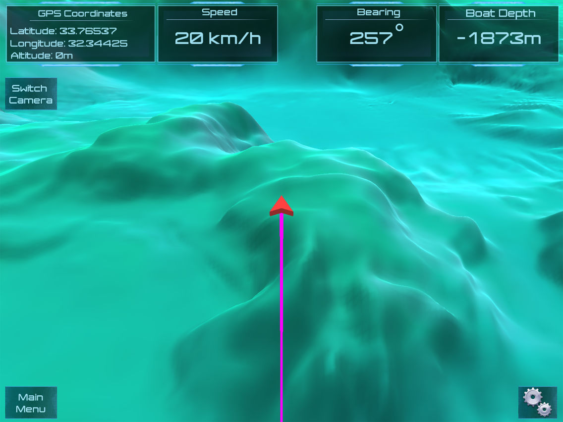
- Terrain and Bathymetric data for Ionian Sea.
- GPS Coordinates Latitude, Longitude and Altitude (Decimal Degrees or Degrees,Minutes,Seconds).
- Depth Units (Meters, Feets, Fathoms).
- Measure Distances (Meters).
- Speed of Vessel (kilometers/hour, miles/hour, knots).
- Bearing of vessel in degrees.
- Current Depth at Vessel position (OFFLINE).

ACCURACY
- Ocean 3D uses the EMODnet digital terrain model (DTM) and has been created at a resolution of 0.125 arc-minutes using the best available bathymetry from a variety of sources. There are still a lot of areas where no high quality bathymetry is available. To prevent gaps in the EMODnet DTM layer, these areas have been filled with the GEBCO 2014 data.
- For Land Terrain, Ocean 3D uses the ASTER Global Digital Elevation Model (ASTER GDEM) with resolution of 1 arc-second (30 meters).

COVERAGE AREA
Top Left Coordinates
- Latitude: 43.15039
- Longitude: 16.88900
Bottom Right Coordinates
- Latitude: 30.24029
- Longitude: 23.34406

More areas coming soon!

IMPORTANT INFORMATION
Although the bathymetry available is based on the best available bathymetry and every effort is made with respect to the quality assurance and quality control, it should be noted that, accuracy, completeness, reliability, usability or suitability of the bathymetry cannot be guaranteed. Therefore the data products available from this service are not to be used for navigation or for any other purpose relating to safety at sea. Ocean 3D, assumes no responsibility for incorrect results or damages resulting from the use of the data.
Show More

What's New in the Latest Version 1.1

Last updated on Jul 25, 2016
Old Versions
- Depth corrections. - Bug fixes.
Show More
Version History
1.1
Jul 11, 2016
- Depth corrections. - Bug fixes.

Ocean 3D Ionian Sea FAQ

Click here to learn how to download Ocean 3D Ionian Sea in restricted country or region.
Check the following list to see the minimum requirements of Ocean 3D Ionian Sea.
iPhone
iPad
Ocean 3D Ionian Sea supports English

Ocean 3D Ionian Sea Alternative

You May Also Like

Get more from Savvas Petrou