OpenSeaMap

OpenSeaMap


$0.99

3.4for iPhone, iPad and more
4.9
4 Ratings
appdoctors UG
Developer
4.5 MB
Size
May 17, 2017
Update Date
Navigation
Category
4+
Age Rating
Age Rating
4+
Apps in this category do not contain restricted content.
9+
Apps in this category may contain mild or occasional cartoon, fantasy or real-life violence, as well as occasional or mild adult, sexually suggestive or horrifying content and may not be suitable for children under 9 years of age.
12+
Apps in this category may contain occasional mild indecent language, frequent or intense cartoon or real-life violence, minor or occasional adult or sexually suggestive material, and simulated gambling, and may be for children under 12 years of age.
17+
You must be at least 17 years old to access this App.
Apps in this category may contain frequent and intense offensive language; Frequent and intense cartoon, fantasy or realistic violence: frequent and intense adult, scary and sexually suggestive subjects: as well as sexual content, nudity, tobacco, alcohol and drugs, may not be suitable for children under 17 years of age.
OpenSeaMap Screenshots
OpenSeaMap posterOpenSeaMap posterOpenSeaMap posterOpenSeaMap posterOpenSeaMap poster

About OpenSeaMap

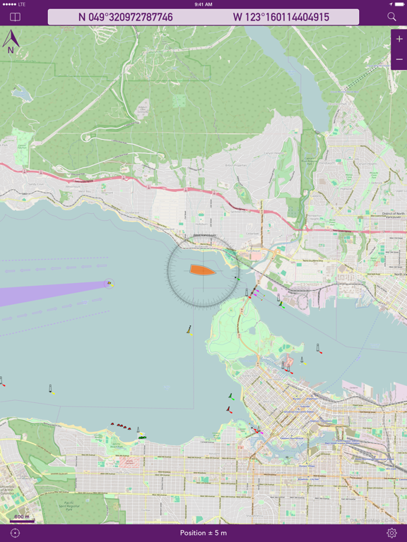
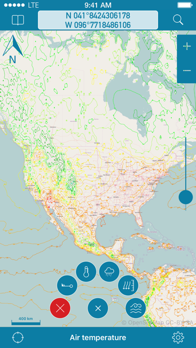
OpenSeaMap is a worldwide Opensource-project for creating a free nautical chart. Founded in 2009 the project gained a lot of attention lately adding more and more nautical information for free. Not even lights and other nautical infos are provided, but also more and more info layers like weather data, information about harbours and so on. As an add on to the OpenStreetMap this provides all missing info for nautical activities. OpenSeaMap is part of OpenStreetMap and uses the same database.


FEATURES:
- Free worldwide sea chart (incl. HD chart graphics)
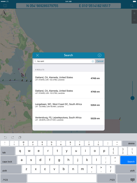
- Search for geolocations worldwide
- Chartplotting with continuous tracking
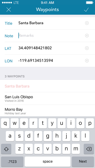
- Waypoints can easily be created, edited, deleted & exported
- Mark locations in the chart
- Zoom chart optically to fit your preferred reading size
- Enter coordinates directly to be displayed in the chart
- Offline caching of up to 1 million map tiles
- Cleanup of chart cache data at any time

+++ NEWS +++ NEWS +++ NEWS +++ NEWS +++
OpenSeaMap app now comes with new In-App-Product "PRO"
this product activates professional features if bought.
NEWS +++ NEWS +++ NEWS +++ NEWS +++ NEWS

To ensure future development and support of the OpenSeaMap app we encourage you to buy the In-App-Product "PRO". This will help keeping new updates and features coming.

DISCLAIMER: OpenSeaMap is part of the OpenStreetMap and uses the same database. As an experienced navigator you should NEVER rely your descisions on one source of information alone. Please keep in mind that the OpenSeaMap can not replace official sea charts on bord of your boat. Please use the OpenSeaMap app only in conjunction with official sea charts and conforming to national and international regulations. Please recognize that no depth information is provided by this product.

IMPORTANT: The continued use of the GPS can significantly decrease the battery level.

LICENSE: This app uses icons from the library http://icons8.com/ we thank for providing these under Creative Commons Attribution-NoDerivs 3.0 Unported License.
Show More

What's New in the Latest Version 3.4

Last updated on May 17, 2017
Old Versions
This app has been updated by Apple to display the Apple Watch app icon.

- Improved information for customers
Show More
Version History
3.4
May 17, 2017
This app has been updated by Apple to display the Apple Watch app icon.

- Improved information for customers
3.3
May 5, 2017
Bugfixes and small improvements.
3.2
Oct 27, 2016
- FIXED: Issues with iOS 10 (i.e. text displayed in map scale view)
3.1
Aug 26, 2016
FIXED: Source for weather data was updated
3.0
Aug 16, 2016
- NEW: Chartplotter (Continuous geotracking)
- NEW: Waypoints (create/change/delete/export)
- NEW: Enter a coordinate directly
- NEW: Improved coordinate display (more precision)
- NEW: Search for geolocations completely rewritten/improved
- NEW: Settings of the app extended with more options
- NEW: Different distance units (meters, miles & nautical miles)
- NEW: Updated Design (Icons & Colors)
- NEW: App Icon with symbol of a buoy of OpenSeaMap
- FIXED: Data sources for weather layers updated
- FIXED: Optimizations for iOS 9, iPhone 6, iPhone 6 Plus & iPad Pro
- FIXED: Improved usability for iPad
2.1.2
Nov 22, 2013
- FIXED: Searchinputfield for iPad did not behave correctly occasionally
- FIXED: Improved lower toolbar behaviour on rotation and overall display
- NEW: Reordered setting switches to better fit importance
2.1.1
Oct 13, 2013
- FIXED: Improvements for iOS 7
- FIXED: Searchbutton stays enabled even after tapping in map now
- FIXED: The powered by screen is now deactivated in PRO version
- NEW: Colors after switching to PRO are now immediately adjusted
- NEW: You can now restore PRO products on other devices with a dedicated button
2.1
Oct 3, 2013
- Optimized for iOS 7
2.0
Jun 15, 2013
- NEW: Optimized for iPhone 5
- PRO: Improved coordinatedisplay
- PRO: Optical zoom slider
- PRO: Weatherlayer (Air Pressure,Temperature,Wind,Waves,Precipitation)
- PRO: Nightviewmode
- PRO: Improved searching for locations
- PRO: Crosshair added for precision
1.1
Feb 10, 2012
- NEW: Support for english language
1.0
Jan 25, 2012

OpenSeaMap FAQ

Click here to learn how to download OpenSeaMap in restricted country or region.
Check the following list to see the minimum requirements of OpenSeaMap.
iPhone
Requires iOS 9.0 or later.
iPad
Requires iPadOS 9.0 or later.
iPod touch
Requires iOS 9.0 or later.
OpenSeaMap supports English, French, German
OpenSeaMap contains in-app purchases. Please check the pricing plan as below:
OpenSeaMap Professional
$1.99

OpenSeaMap Alternative

You May Also Like

Get more from appdoctors UG