OTAMap

OTAMap


$2.99

2.2for iPhone, iPad and more
7.1
9 Ratings
Arctic Surf Designs
Developer
29.1 MB
Size
Sep 25, 2017
Update Date
Utilities
Category
4+
Age Rating
Age Rating
4+
Apps in this category do not contain restricted content.
9+
Apps in this category may contain mild or occasional cartoon, fantasy or real-life violence, as well as occasional or mild adult, sexually suggestive or horrifying content and may not be suitable for children under 9 years of age.
12+
Apps in this category may contain occasional mild indecent language, frequent or intense cartoon or real-life violence, minor or occasional adult or sexually suggestive material, and simulated gambling, and may be for children under 12 years of age.
17+
You must be at least 17 years old to access this App.
Apps in this category may contain frequent and intense offensive language; Frequent and intense cartoon, fantasy or realistic violence: frequent and intense adult, scary and sexually suggestive subjects: as well as sexual content, nudity, tobacco, alcohol and drugs, may not be suitable for children under 17 years of age.
OTAMap Screenshots
OTAMap posterOTAMap posterOTAMap posterOTAMap posterOTAMap poster

About OTAMap

Works for both FM and TV! Loaded with new features in 2.0!

Use OTAMap to find and point your antenna to all your Over The Air (OTA) television and FM stations.

OTAMap gives you the latest Over The Air (OTA) television/FM station information. for all of the continental USA, Alaska, Canada, Hawaii, Northern Mexico and some US territories such as Puerto Rico.

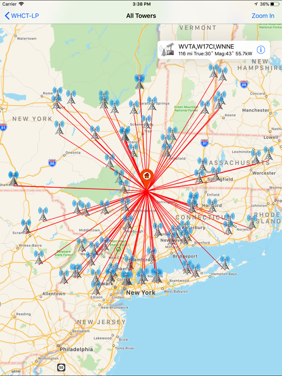
OTA Map will list all OTA channels/stations within 150 miles of your current geographical position as indicated by your iPhone/iPad. With this tool you can quickly see what OTA stations may be available in your area.

With OTAMap you can view the position of the transmission towers, of any of these Over The Air television stations, in relationship to you. This can be used to help adjust your HD OTA antenna for local reception, for that hard to get station, or even the far far away channel that you have been trying to "DX" for quite a while. Whether you are on your roof or turning your rotor from your living room, OTAMap can help you.

*****Note to Northern Canadian Users: OTAMap does work everywhere in Canada (including Edmonton), however you may need to flip on the Industry Canada Data in the preferences.

Some of the new features in 2.0
Now you can choose between FM or TV stations
•You can filter station list based on distance, power, FCC data, Industry Canada data, Canadian, Mexican and US stations.
•You can now even filter based on whether your location falls within a stations 41 dBU Contours!
•You can sort the displayed stations by distance, channel, power or even it's bearing from you.
•Save and recall locations.
•Do locations based on
-Actual GPS
-Entered GPS (IOS 6.1 and higher only)
-ZIP/postal code (IOS 6.1 and higher only)
-Street Address (IOS 6.1 and higher only)
-Or a previously saved location.
•Download and update latest FCC station data anytime.
•No longer server based. Some functionality will run without a network connection. If a particular map was previously loaded, even mapping functionality may work offline.
•Fixed magnetic declination (no longer IRC dependent) (may be off as you near the Arctic Circle).
•Added ability to add stations/save maps to a DX list. The list can be pulled up anytime and the pointing maps reviewed.
•Added Super Contour Map. Given a particular location it -will list all stations that fall within the 41/60 dBu contour map which should indicate stations that should be received relatively easily. Will show curves of all coverage contours and darken overlapping sections. The resulting stations can then be viewed as your filtered station list.
•Added a search for call sign option. This will allow mapping of super long range reception or help in obscure DX attempts.
•Now works for all of the Great White North - Uses IRC data for anything not included in the FCC database.
•In the station pointing map view the map can be updated if the users gps determination has changed.
•In the station pointing and the all station map views, you can drag the home icon to say a different part of the roof/yard and the calculations will follow.
•You can erase your downloaded data (which may include FCC FM/TV database and any cached contours) and restore to original data from preference menu.
Show More

What's New in the Latest Version 2.2

Last updated on Sep 25, 2017
Old Versions
This app has been updated by Apple to display the Apple Watch app icon.

Required changes for IOS 11
Improved UI changes for iPad version!
Fixed fcc web pages
Fixed individual contour maps
Now it starts with 120 miles and all stations greater than 1kw
Temporarily removed super contour - will enhance and include in next update
More features coming!...
Show More
Version History
2.2
Sep 25, 2017
This app has been updated by Apple to display the Apple Watch app icon.

Required changes for IOS 11
Improved UI changes for iPad version!
Fixed fcc web pages
Fixed individual contour maps
Now it starts with 120 miles and all stations greater than 1kw
Temporarily removed super contour - will enhance and include in next update
More features coming!...
2.1
Aug 1, 2014
•Added Compass functionality. You can now point to station with compass or satellite map.
•Added Sort by Estimated Signal Strength option.
•Move most used aspects of preferences to Main Page.
•Added range indicator in DX lists
•Removed About Us and Blog.
•Added Help Menu
Please give me some feedback on all the new features!
2.0
Jul 11, 2014
Some of the new features
-Now you can choose between FM or TV stations
-You can filter station list based on distance, power, FCC data, Industry Canada data, Canadian, Mexican and US stations.
-You can now even filter based on whether your location falls within a stations 41 dBU Contours!
-You can sort the displayed stations by distance, channel, power or even it's bearing from you.
-Save and recall locations.
-Do locations based on
Actual GPS
Entered GPS (IOS 6.1 and higher only)
ZIP/postal code (IOS 6.1 and higher only)
Street Address (IOS 6.1 and higher only)
Or a previously saved location.
-Download and update latest FCC station data anytime.
-No longer server based. Some functionality will run without a network connection. If a particular map was previously loaded, even mapping functionality may work offline.
-Fixed magnetic declination (no longer IRC dependent) (may be off as you near the Arctic Circle).
-Added ability to add stations/save maps to a DX list. The list can be pulled up anytime and the pointing maps reviewed.
-Added Super Contour Map. Given a particular location it -will list all stations that fall within the 41/60 dBu contour map which should indicate stations that should be received relatively easily. Will show curves of all coverage contours and darken overlapping sections. The resulting stations can then be viewed as your filtered station list.
-Added a search for call sign option. This will allow mapping of super long range reception or help in obscure DX attempts.
-Now works for all of the Great White North - Uses IRC data for anything not included in the FCC database.
-In the station pointing map view the map can be updated if the users gps determination has changed.
-In the station pointing and the all station map views, you can drag the home icon to say a different part of the roof/yard and the calculations will follow.
-You can erase your downloaded data (which may include FCC FM/TV database and any cached contours) and restore to original data from preference menu.
1.0
Jun 14, 2011

OTAMap FAQ

Click here to learn how to download OTAMap in restricted country or region.
Check the following list to see the minimum requirements of OTAMap.
iPhone
Requires iOS 9.0 or later.
iPad
Requires iPadOS 9.0 or later.
iPod touch
Requires iOS 9.0 or later.
OTAMap supports English

OTAMap Alternative

You May Also Like

Get more from Arctic Surf Designs