Fast initial download. Maps are then dowloaded automatically.
Fixed track recording in iOS 17.
Fixed the settings menu in landscape mode on iPhone.
Fixed low frame rate when the information bar is enabled.
The map's highest detail is now displayed while scrolling.
Updated maps and bug fixes.
iOS 13 support
Updated map data
Fixed GPX file import issue
Fixed import of GPX files via email in iOS 13.
Fixed the in-app documentation.
Updated map data.
Updated map data with fix for missing river names.
Additional bug fixes.
Support for the iPhone X, updated maps with improved line drawing and the usual crop of bug fixes.
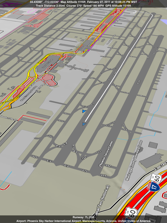
New grid overlay including the US Civil Air Patrol grid for the continental USA and Alaska.
The Show iAds option was removed since iAd has been discontinued.
Updated map data.
Fixed many bugs.
Satellite high resolution image overlay. Enable the Online Map and tap preset 2 or 4.
Cache size controls and a new Purge Cache button in the settings menu.
Split screen supported in iOS 9 on compatible iPads including iPad Pro.
Show or hide large park or land cover polygons.
Auto mode for terrain shading for use with the satellite maps when zoomed in.
Two additional levels of zoom to show the highest resolution satellite images.
Much smoother animation when scrolling the map or slewing in joystick mode.
Many other bug fixes and minor improvements.
Fixed a crash that happens after the map cache is purged.
Fixed a minor user interface bugs.
In-app documentation for use when you are offline.
You can now select Stop Recording Track when you tap the lock icon in the toolbar.
Map and UI speed improvements.
Renamed a few items in the settings menu.
Bugs squashed.
Scenic Map now includes coverage of the entire world via cloud data on iOS 8. The map is cached automatically for offline use. Turn on Online Maps in the settings menu.
Support for iOS 8 and the iPhone 6 and iPhone 6 Plus.
Display multiple tracks at the same time.
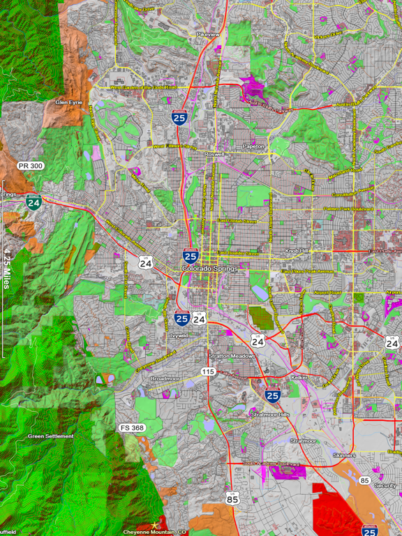
Improved and updated maps with more rendered features.
Nautical distance units.
1.6.1: Minor bug fixes and feature enhancements.
1.6: BLM Lands overlay. Offline map search. Online local search, address search and address lookup. Automatic route generation to any point while online. County lines. Time zones. Many more enhancements and iOS 7 support.
New Features: BLM Lands overlay. Offline map search. Online local search, address search and address look up. Automatic route generation to any point while online. County lines. Time zones. Many more enhancements and iOS 7 support.
Like free updates? Please leave us app reviews and ratings!
Note: iOS needs 5 GB free storage to update this app.
Waypoint names are now displayed in the map.
Improved GPX file import compatibility
Switch to another Scenic Map when you leave the coverage area.
All known bugs in version 1.5 have been fixed.
Waypoint import/export. Send waypoints to Apple Maps or other apps. iPhone 5 screen support, updated maps with more parks, simplified gestures for beginner users and advanced modes for pros. Better GPS tracking.
Note: By default the Joystick Gestures are disabled. Turn them on in the Settings menu. You can also choose to unify the map tilt & scale between all presets.
In iOS 6, the Automatic Tracking option will automatically stop tracking and turn off the GPS after the device has been stationary for a short time. This will save battery power.
You can now turn Glaciers on or off with the Area Water option.
There is a 2D Map preset option and many other small fixes and improvements.
A track can now be displayed while a new track is recorded or an existing track is replayed.
You can now turn off Large Maps on newer devices for more speed.
Updated map data.
Fixed a bug that prevented the app from working on an iPad 2 under iOS 4.
Version 1.4: Road names now follow the roads.
Full Retina display support and up to 4x rendering speed.
New coordinate formats including DMS and UTM.
Send GPX track files to other apps.
Now compatible with the Verizon iPhone 4.
Version 1.4: Road names now follow the roads.
Full Retina display support and up to 4x rendering speed.
New coordinate formats including DMS and UTM.
Send GPX track files to other apps.
Note: This version is incompatible with the Verizon iPhone 4. A new version will be released to fix this bug.
Road names now follow the roads (by popular demand).
Full Retina display support and up to 4x rendering speed.
New coordinate formats including DMS and UTM.
Send GPX track files to other apps.
2D or 3D maps. The choice is yours. Use a two finger vertical swipe to tilt the map from a 2D top down view to a 3D gound level view or anywhere in between. You can keep North pointing upwards or rotate the map freely via a user setting.
Scenic Map now employs a combination hardware/software renderer to take advantage of all the power of mobile devices. The result is simply stunning. You can now fly over terrain at hyper velocity or perform slow majestic turns around mountains or other interesting topology. Part helicopter, part jet fighter, part rocket, you are in full control.
Scenic Map turns any drive into a futuristic 3D animated experience. Now you can see beyond the immediate horizon and know what terrain is coming up just around the turn or beyond the next hill. From the window seat of a plane, you can now pinpoint your current location, heading and speed while identifying all the roads, towns and terrain features you can see below you. Please be ready to answer a lot of questions from the other people in your row (take it from personal experience).
Scenic Map 1.3 has new gestures to let you fly around, rotate, tilt and zoom the map. There is complete documentation on scenicmap.com but here is a quick guide to get you started:
There are two modes of operation: Standard Mode and Joystick Mode. To change modes touch and hold with one finger for two seconds. You will see a single ring around the point you are touching to indicate Standard Mode and double rings to indicate Joystick Mode.
In Standard Mode, use a single finger to scroll the map around as usual. Swipe gestures will scroll with momentum (the map will keep scrolling after your finger leaves the screen). A two finger sideways swipe will rotate the map's direction. A two fingered vertical swipe will adjust the map's tilt. You can also use two finger gestures to pinch and rotate the map in the standard way. Only one of the two finger gestures can be used at one time. We find this makes the map a lot easier to control.
In Joystick Mode, use a single finger to fly the camera forwards or backwards. Sideways finger motion will cause the map to rotate. The more you move your finger away from the point you first touched, the faster the map will move or turn. You can combine horizontal and vertical finger motion to orbit the camera around interesting terrain features. A two fingered horizontal swipe will move the map sideways. A two fingered vertical swipe will adjust the tilt. You can also use two fingered gestures to pinch and rotate the map but all of these gestures are spring loaded in joystick mode. In addition while using a single finger to fly the camera, you can touch with a second finger to perform sideways moves.
All the other gestures such as double tap to zoom in and triple tap to zoom out work as they did before. If you really liked the old 2D mode, it is still present in 1.3. Just tilt the map to vertical and set the North Up option in the Map Style panel (tap the gear icon in the tool bar at the top of the screen and then scroll down).
We are very interested to hear your feedback about this new version. Please feel free to e-mail us at scenicmap@gmail.com or leave a comment on the scenicmap.com blog.
Updated Open Street Map Data. Improved highway badges. Minor bug fixes.
Please Note: This update is almost 2GB in size. We recommend downloading it with iTunes on your computer and syncing it to your iOS device.
Please Note: Future versions of Scenic Map will require iOS 4.2 or higher.
You now have a smoooooth moving map that works while hiking, driving or flying!
Scenic Map continues its evolution with this first major update. The map rendering is now much faster and fills in as you scroll. The map data has been updated and includes new features such as airport runways, parking lots and shopping centers. Waypoints can be fully edited and displayed on the map. A dashed line will show you the direction to the selected waypoint or your current GPS location as the map scrolls..
The information display now includes your track length, both GPS and map altitude, your current speed and heading in either English or Metric units. All of these update in real time while scrolling, zooming or tracking. The digital compass is used to display your current viewing direction on the map. There is also a scale overlay.
There are too many other small fixes and user interface improvements to list individually. Try it out. It will feel like a whole new app!
▶The map updates faster when scrolling and uses less battery power when tracking.
▶You can now drag the light to change the angle of illumination.
▶Double tap to zoom in. Triple tap to zoom out.
▶Two finger tap to change the month or reset the angle of illumination.
▶The map text is easier to read.
▶City search now tells you if no matches were found.
▶GPS tracking will no longer scroll the map out of the coverage area.
▶Fixed a bug in the GPS tracking that could cause the app to crash.
▶Updated roads and buildings from Open Street Map.