Terrain Navigator Pro

Terrain Navigator Pro


Free

2.3.5for iPhone, iPad and more
4.9
17 Ratings
Trimble Inc.
Developer
65.4 MB
Size
Dec 23, 2020
Update Date
Productivity
Category
4+
Age Rating
Age Rating
4+
Apps in this category do not contain restricted content.
9+
Apps in this category may contain mild or occasional cartoon, fantasy or real-life violence, as well as occasional or mild adult, sexually suggestive or horrifying content and may not be suitable for children under 9 years of age.
12+
Apps in this category may contain occasional mild indecent language, frequent or intense cartoon or real-life violence, minor or occasional adult or sexually suggestive material, and simulated gambling, and may be for children under 12 years of age.
17+
You must be at least 17 years old to access this App.
Apps in this category may contain frequent and intense offensive language; Frequent and intense cartoon, fantasy or realistic violence: frequent and intense adult, scary and sexually suggestive subjects: as well as sexual content, nudity, tobacco, alcohol and drugs, may not be suitable for children under 17 years of age.
Terrain Navigator Pro Screenshots
Terrain Navigator Pro posterTerrain Navigator Pro posterTerrain Navigator Pro posterTerrain Navigator Pro posterTerrain Navigator Pro poster

About Terrain Navigator Pro

Terrain Navigator Pro provides an affordable and simple solution for professionals to collect and seamlessly transmit data from the field to the office. Use the TNP mobile app to map, find, collect, and share field data. Then, with a mobile connection, instantly share field data with the TNP desktop software to analyze GPS and GIS data at the office.
TNP serves a professional market, including search and rescue teams, law enforcement, foresters, surveyors, the oil and gas industry, and land managers. This mobile app is ideal for entry-level GIS applications and enables professionals to use the smartphone in their pocket instead of a consumer-grade GPS device.

To activate this app, users need a licensed copy of the Terrain Navigator Pro desktop software version 9.2 or later.

To learn more about TNP, visit the Terrain Navigator Website at www.terrainnavigator.com.

OFFLINE DATA COLLECTION
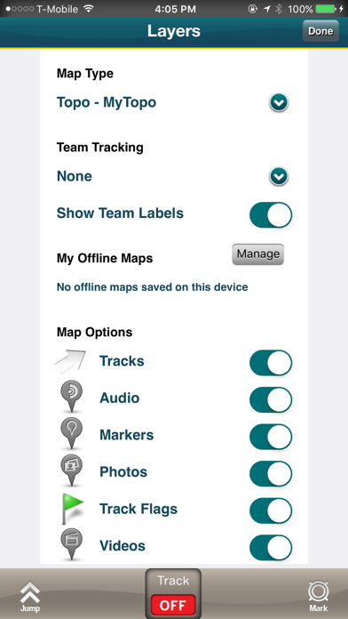
The TNP mobile app uses the GPS built into the iPhone, so professionals can collect field data in areas without a cellular or data signal. In addition, users can download and store topographic, aerial, and street maps onto the phone for offline use and data display. Your data is stored on your iPhone, so there’s no need to have a network connection.
----------------------------------

TNP CLOUD
Got a Wi-Fi or data connection? Share your data in near real-time with colleagues at the office to streamline project workflows. The TNP app uploads data as it’s collected, so professionals with the same project open in the TNP desktop software can view the field data and collaborate to make accurate, on-the-spot decisions.
----------------------------------

TNP MOBILE APP FEATURES

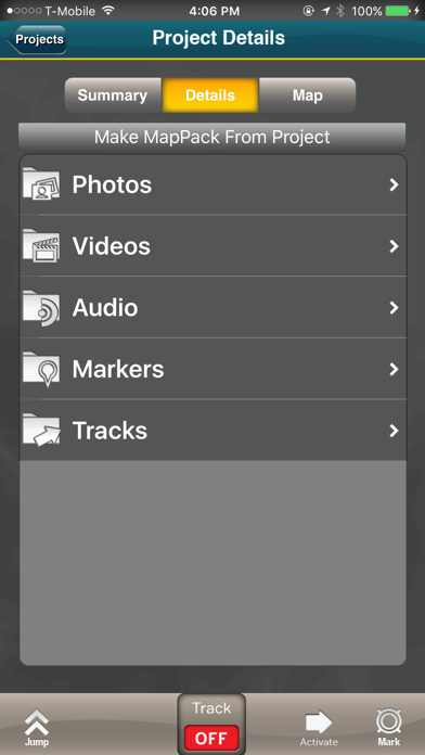
•Collect field data (markers, tracks, photos, videos, audio clips) in areas without a cellular or data signal.
•Near real-time sync between phone and TNP map software via Wifi or data connection like a 3G network.
•View data on topographic, aerial, and street maps downloaded to phone for offline use. Terrain Navigator Pro offers 1-meter aerial photos for the 48 contiguous United States. The seamless USGS topographic maps are based off 1:24K, 1:100K, 1:250K map scales. Alaska is 1:63K and 1:250K.
•Access a compass and other geo-information such as latitude/longitude, elevation, and direction on phone.
•New Feature for TNP Enterprise customers - team tracking shows where your users are in near real time. Support for team projects which allow organizations to control data users can see
----------------------------------

TNP DESKTOP SOFTWARE
This app syncs to our award-winning Terrain Navigator Pro mapping software, which has been fine-tuned based on more than a decade of feedback from professionals who rely heavily on maps in the field. The TNP software provides access to an easily catalogued collection of USGS/US Forest Service topographic maps, including 1:24,000 (7.5 minute series), 1:100,000 and 1:250,000 scale as well as seamless, 1-meter resolution color aerial photos dating back to 2003, and up to the most recent National Agriculture Imagery Program (NAIP) aerial imagery available. The software supports GIS and CAD export and import, and provides access to advanced mapping tools, including: range rings by time and distance, area fills and line-of-sight height offsets, geo-pins, geo-tips, Public Land Survey System (PLSS), advanced address search, up-to-date street data, and more.
----------------------------------

Notes: Terrain Navigator Pro is designed for your iPhone device. Continued use of GPS running in the background can dramatically decrease battery life.
Show More

What's New in the Latest Version 2.3.5

Last updated on Dec 23, 2020
Old Versions
Bug Fixes and performance improvement.
Show More
Version History
2.3.5
Dec 23, 2020
Bug Fixes and performance improvement.
2.3.4
Dec 10, 2020
Bug fixes and performance improvement.
2.3.3
Oct 28, 2020
Improved stability and minor bug fixes.
2.3.2
Aug 29, 2019
Bug Fixes
2.3.1
Jul 15, 2019
-Bug fixes and performance improvement
2.3.0
Apr 9, 2019
Included Forestry Cruising MVP.
Performance upgrade.
Bug Fixes.
2.2.3
Nov 29, 2018
Minor Bug fixes
Improved stability
2.2.2
May 29, 2018
Bug Fixes
2.2.1
Oct 23, 2017
Bug fixes.
2.2
Oct 19, 2017
Bug fixes.
2.1.9
Sep 25, 2017
Updated to support TNP Desktop 11.03
2.1.8
Jul 12, 2016
- The Home screen has been replaced by the Navigation Menu at the top-left corner of the TNP app; access all features directly from the Navigation Menu.
- TNP now supports 'Mobile Maps', purchased areas of map coverage and parcel boundaries and includes full access to the TNP app and website.
- With our new 'Purchased' tab in the MapPack section, you can now download the parcel data for purchased states/Mobile Maps directly from the TNP app.
- Minor bug fixes and other misc. improvements.
2.1.7
Feb 12, 2016
Bug Fixes
2.1.6
Jan 28, 2016
Fixes an issue that affects iOS 9+ devices that prevents the application to continue tracking while in the background.
Other bug fixes and improvements
2.1.5
Dec 17, 2015
Bug fixes and improvements
2.1.4
Nov 6, 2015
+ We added a timer when in stationary collect so you know for how long you have been collecting locations.
+ Ability to select zero in arrival distance.
+ Ability to export/import trips in zip files.
+ Added Start/End options to the Goto dialog when selecting a track.
+ Fixes and improvements.
2.1.3
Jul 23, 2015
Fixes an issue where the offline maps where showing the incorrect map types
2.1.2
Jun 22, 2015
• Added ability to view track area
• Bug fixes and improvements.
2.1.01
Feb 27, 2015
• TNP added to the Background App Refresh iPhone Settings screen.
• Now using 8 decimal numbers for Lat and Lon.
• Fixed a Refresh issue in the SOS button when turning off Live Tracking.
2.1
Feb 4, 2015
- Fixes an issue where GPS doesn't work as expected in iOS 8 devices.
+ New Create Map Packs screen.
2.0.4
Jan 28, 2015
- Bug Fixes
2.0.3
Oct 23, 2014
• 1, 3 and 5 minute team tracking update intervals added
• Team tracking toggle added to the main screen to provide better feedback.
• Fixed a crash that was causing iOS 5 to crash when entering to any screen.
• USNG support added
• “My Projects” filter in My Projects screen now shows only private projects.
• Ability to delete Mega Offline Maps within the app.
• Fixed last updated date for current user not accurate.
• Fixed an issue that was preventing Private Lands not to show up for some counties.
• Fixed an issue where the trip total distance was not being updated for new tracks created on the Desktop.
2.0.2
Sep 4, 2014
• Aerial, Streets and Hybrid map types added.
• Allows importing polygon from KML files.
• Added Toggle button to turn on/off the shading on the polygons when being drawn in the map screen.
• Allows to put duplicated stats in the Statistics screen.
• Better looking tracks.
• Fixed graphical issues in the Compass screen.
• Fixed accuracy on trip total distance.
• Other bug fixes.
2.0.1
Aug 1, 2014
Bug fixes and improvements.
2.0.0
Jun 5, 2014
Minor bug fixes
Improvements to project synchronization
Team tracking - enterprise only
Team projects - enterprise only

Terrain Navigator Pro FAQ

Click here to learn how to download Terrain Navigator Pro in restricted country or region.
Check the following list to see the minimum requirements of Terrain Navigator Pro.
iPhone
Requires iOS 10.0 or later.
iPad
Requires iPadOS 10.0 or later.
iPod touch
Requires iOS 10.0 or later.
Terrain Navigator Pro supports English

Terrain Navigator Pro Alternative

You May Also Like

Get more from Trimble Inc.