Fix for graphics glitches affecting some devices on iOS 17.
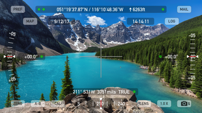
Theodolite 9.0.2 adds options for two compass sensor algorithms in PREFS > Advanced. "More Robust" (default) is a new option intended for general use in a variety of environments, including locations with moderate electromagnetic interference. It was implemented in response to more and more customers attempting to use the compass in marginal situations. "More Sensitive" (previous default) uses 3D vector components of magnetic field to give higher fidelity measurements, but should only be used in clean electromagnetic environments. With either option, be mindful of local compass sensor accuracy, shown by tapping any of the green/red dots on the viewfinder screen.
Theodolite 9.0-9.0.1 added: New options for viewfinder graphics colors. Option to show planets in AR overlay. Ability to use sunrise/sunset/horizon to control display of AR layer content. Added help tips to status screen for common compass issues. Added links to iOS Settings for common privacy/permission issues. Added support for dual-wide cameras. New AR display of map markers in main viewfinder. Option for export of files to local iPhone or iCloud (log, map markers, map polygons).
Theodolite 9.0.1 fixes an issue on certain dual-wide camera devices that caused a crash on startup. Theodolite 9.0 contains: New options for viewfinder graphics colors. Option to show planets in AR overlay. Ability to use sunrise/sunset/horizon to control display of AR layer content. Added help tips to status screen for common compass issues. Added links to iOS Settings for common privacy/permission issues. Added support for dual-wide cameras. New AR display of map markers in main viewfinder. Option for export of files to local iPhone or iCloud (log, map markers, map polygons).
New options for viewfinder graphics colors. Option to show planets in AR overlay. Ability to use sunrise/sunset/horizon to control display of AR layer content. Added help tips to status screen for common compass issues. Added links to iOS Settings for common privacy/permission issues. Added support for dual-wide cameras. New AR display of map markers in main viewfinder. Option for export of files to local iPhone or iCloud (log, map markers, map polygons).
Outdoors maps now use larger tiles for faster rendering and 3-4X reduction in tile usage. Offline maps now show a dashed line to indicate the boundary of the offline tile set at all zoom levels. Fix for App Store screenshots.
Outdoors maps now use larger tiles for faster rendering and 3-4X reduction in tile usage. Offline maps now show a dashed line to indicate the boundary of the offline tile set at all zoom levels.
New styling and content for Outdoors maps, with additional features and more detail. This change will not affect any previous offline maps you have stored.
New perspective rendering engine for improved positioning of AR layer objects at wide angles.
Theodolite 8.0.1 addresses iOS 13.2 issues affecting offline maps and corrects segmented control tint on devices running dark mode. Theodolite 8 includes triple camera support and rangefinder updates for new devices. Auto logging with time and angle motion intervals. New 5 degree wire reticle option. Option to show 5 degree angle markings in photo/movie overlays. Outdoors map rendering improvements for iOS 13. Geocentric Datum of Australia 2020 (GDA2020) with 0.1m precision added to datum pack. Geocentric Datum of Australia 1994 (GDA94) updated to 0.1m precision. Map Grid of Australia (MGA) option added to position formats. New option for black text and graphics in photo/movie overlays. Photo/movie overlays and EXIF metadata now display accuracy data.
Triple camera support and rangefinder updates for new devices. Auto logging with time and angle motion intervals. New 5 degree wire reticle option. Option to show 5 degree angle markings in photo/movie overlays. Outdoors map rendering improvements for iOS 13. Geocentric Datum of Australia 2020 (GDA2020) with 0.1m precision added to datum pack. Geocentric Datum of Australia 1994 (GDA94) updated to 0.1m precision. Map Grid of Australia (MGA) option added to position formats. New option for black text and graphics in photo/movie overlays. Photo/movie overlays and EXIF metadata now display accuracy data. Bug fixes, tweaks for iOS 13, and graphics improvements.
Theodolite 7 lays the groundwork for the next several years of development. The app introduces it's first AR layers, including navigational aids like the sun, moon, and Polaris (North star), and adds a brand new in-app purchase that shows over 70,000 US mountain summits in the viewfinder. These AR layers support Theodolite's new compass correction mode, which lets you slide your finger on the screen to correct compass errors and offsets by aligning the compass with known references. Theodolite 7 brings improvements to night modes, makes it easier to find and buy in-app purchases, and has numerous user interface improvements and tweaks throughout the app. Support for all the latest iOS devices has been added.
Bug fix for crash when opening URLs for team invites, data sharing, and camera sharing.
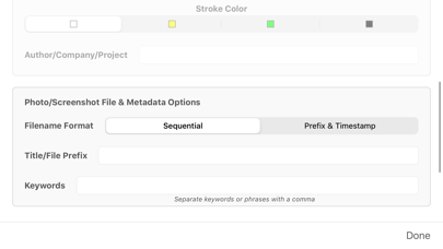
Added an option for sequential naming/numbering of photo files in Preferences > Camera Options. Filenames will be of the format "THnnnnnn.JPG" where nnnnnn is an internal Theodolite photo sequence number. This will avoid the issue PC users were seeing with random alphanumeric filenames when importing photos, and let Mac users choose a sequential file name format if they prefer. This is now the default option, but users can change back to the more descriptive prefix/timestamp naming of files introduced with Theodolite 6.1. See the user manual for more info on photo file naming.
The map will now center and zoom on an imported polygon, and polygons now show a marker on the first point to aid visibility when zoomed out.
Added ability to import map marker and polygon KML files from the app's local documents folder (accessible from the iOS 11 Files app or iTunes on a Mac/PC). This will provide an import path for people who don't use iCloud Drive.
* New feature to create and show polygons on the map screen to mark land boundaries, trails, etc, with KML import/export of polygon data.
* New camera sharing feature lets third party apps use Theodolite to capture photos and screenshots. Sample code available. See the user manual for details.
* Added explicit permission request for photo album access when app first launches to avoid user confusion when taking the first photo.
* Added a "swipe up from bottom“ hint for users new to iPhone X who can't figure out how to close Theodolite.
* Added location and altitude indicator bars on the status screen to show location and GPS data quality.
* Added option to adjust the size of saved photos to 25%, 50%, or 100%.
* Added input in camera options to specify author/company/project name in photo/movie data overlay.
* Added input in camera options to specify a title/file prefix to be associated with saved photos and screenshots.
* Added input in camera options to specify keywords to be associated with saved photos and screenshots.
* Improved photo/movie overlay quality at lower resolutions.
* Improved frame rendering of screenshots and screen movies on devices with an odd-number display dimension.
* Fixed bug affecting date format in regions outside the US.
* Bug fix to avoid crossed corners when defining offline map regions.
* Bug fix to avoid issues when exporting log KML data when non-ascii characters were used in user comments.
* Option for coupled Euler angle convention for elevation/horizon
* Added 8X zoom on devices with dual cameras
* Added CSV file to log export
* Log export option for iCloud Drive
* Separate options for date/time and data in photo overlay settings
* Added option to also save original image when taking overlay photos and screenshots
* Added date to main viewfinder screen
* Added log notes to placemark descriptions in KML log export
* New SPCS83 options for US survey feet and standard feet added to State Plane in-app purchase
* SPCS 83 Easting,Northing search on map screen (with State Plane in-app purchase)
* New option for Maidenhead locator system coordinates
* Compass calculation improvements at off-angles
* Import and export options for map markers (KML format)
* New "delete all" option for map markers
* Costa Rica 2005 (CR05) and Hong Kong 1980 (HK80) datums added to Datum Pack in-app purchase
* Added ability to get directions to map markers using Apple Maps
* Added 6th decimal place display precision for lat/lon coordinates (does not imply that GPS will be accurate to 6th decimal place)
* Display formatted position string in log in addition to lat/lon
* Increased precision for A-B calculations
* Region bug fix for offline maps
* Fix to KML export to correct camera view angle
* Scale indicator shown on map
Theodolite 5 is our biggest new release ever, with many new features and improvements. Here are some of them:
* Fully compatible with iOS 10, iPhone 7, iPhone 7+
* In-app purchase for offline Outdoors maps with topo contours (feet or meters), roads, trails, landmarks, campgrounds, ski lifts, and more.
* In-app purchase for US State Plane Coordinates. SPCS27 and SPCS83 are included for all US state zones.
* Addition of US National Grid position formats with 10/100/1000 meter precision.
* New datums added to Datum Pack: GDA94, GGRS87, JGD2000, ETRS89, NZGD2000.
* Distance/heading to active selected map marker show on main display along with aim indicator arrows (lower left).
* Sweeping azimuth sight line added to map pointer.
* Status indicators for position and altitude now blink to indicate GPS activity and glow steady to indicate GPS lock.
* Hardware status screen now updates accuracy numbers in realtime.
* Position activity/lock indicator (spinning wheel) shown on current location map pin.
* Smoother location updates on map screen.
* Revised map marker popups for more display area to show long coordinates/names.
* Added search format selection buttons to map search bar.
* Improved finger tracking response of 4X-24X variable rangefinder reticle.
* Revised floating crosshair reticle target to track horizon (previously was a pendulum).
* Addition of camera tags to KML when using main screen mail export.
* Dramatically sharper optical quality on main screen when using zoom.
* Option to add note to a log entry.
* Added datum code to log entries.
* Fixed UTM position search issues.
* Corrected behavior of UTM and MGRS coordinates when legacy datums (NAD27) are used.
* Added description of datum to photo/movie data overlay.
* Fix for bug in altitude computations affecting some datums.
* Improvements to rangefinder rendering.
* Addition of photo EXIF tags including app name and elevation/horizon angles.
* Dual usage of WGS-84 coordinates for proper compatibility with map content and data export formats when running an alternate datum.
* Dozens of interface tweaks and improvements throughout the app.
Thanks to our amazing customers whose feedback and suggestions over the past seven years have helped make Theodolite a great app! We appreciate your support. We're finalizing the next version of Theodolite, due out in the fall of 2017 after iOS 11 is released. If you have any feature requests, feedback, or suggestions, please contact us. Thanks!
This is a quick update to fix a graphics freezing problem caused by iOS 8.2. In addition, Theodolite will now warn users if they have not given permission to use the device camera in iOS 8 (previously the app would just quit if the camera wasn't available). Stay tuned for an all-new Theodolite 5 coming soon with many new features -- it's going to be our biggest update ever! Theodolite 5 will be a free upgrade for existing customers. Theodolite 5 was submitted to Apple for Review in late August, and should be available shortly.
ATTENTION IOS 8 USERS: When Theodolite launches in iOS 8 for the first time, iOS puts up a dialog asking you to give the app permission to access the camera. Many people are mistakenly clicking "no", which causes Theodolite to display a black camera view or simply not launch. If you have denied permission to access the camera, you can override this in System Settings > Privacy > Photo. This permission dialog is from iOS, not Theodolite, so please direct further feedback about this to Apple.
* Fully compatible with iOS 8 and iPhone 6/6+
* Redesigned user interface for iOS 7/8.
* Fix for quitting issues on iOS 7/8 if user denies permission to access the microphone with the app's movie mode enabled.
* Added optical rangefinder specs for iPhone 5S.
* Theodolite will now disable movie recording if user denies permission to access the microphone.
* Theodolite will now disable photo capture and movie recording if the user denies permission to access the photo album.
Check your privacy options in System Settings > Privacy to override these behaviors (this is part of iOS, not Theodolite).
ATTENTION iOS 7 USERS: if the app quits on launch, it is because you did not allow access to the microphone. You can override this in system settings > privacy > microphone. For more information, see the app's user manual FAQ section or e-mail the developer. Please do not leave tech support requests in iTunes reviews, as we have no way to respond to you.
What's new:
* Optional "Datum Pack" in-app purchase that adds over 220 new geodetic datums to the app for more accurate position and altitude computation from GPS data. Datums include NAD-27, NAD-83, OSGB-36, ED-50, and hundreds of others, covering regions and countries on all continents around the world.
* Four new position formats for the UK and Ireland, including British National Grid and Irish National Grid. Absolute and Subgrid relative Eastings and Northings are given.
* Revised hardware status indicators and status screen.
Fixed issues with map marker sharing, team sharing, and banner graphics. Added rangefinder specs for newly announced iOS devices.
Support for iOS 6 and iPhone 5. Improvements to map marker sharing. Improved rendering of map markers, compass rose, and azimuth pointer. Live map markers, with realtime distance/heading updates (relative to current position). Map marker sharing and e-mail export integration with Gaia GPS. Improved handling of MGRS, UTM, and UTM-B search/lookup on map screen using format prefixes (see user manual for details). Variable 4X-24X rangefinder scope reticle. SLR camera style round wire reticle with focus prism and exposure indicator. Team tracking available through in-app purchase (see user manual for details).
NEW! Movie recording, with optional screen/watermark overlays and multiple video quality settings. Three large-format stadiametric rangefinders (sniper/artillery/hunter style, showing distance multipliers, yards, or meters). Revised position formats with new decimal minutes option. Larger font sizing for photo data stamp watermark, with three color options. Onscreen indicator for magnetic declination errors. Bug fix to e-mail export URLs. Numerous performance improvements and tweaks.
Ability to share map markers and A-B points with other users of Theodolite Pro and Theodolite HD via SMS text messages and e-mail. To access this feature, tap any marker shown on the built-in map, and then tap the "Share" button on the marker's popup. Data shared from normal markers includes position and marker name. Data shared from A or B points include position, altitude, azimuth, elevation angle, and horizon angle. This allows users to share A-B measurement points for distributed and team calculations.
Fixed bug in storage of map markers and added rangefinder lens specs for the iPhone 4S.
Combined distance/height calculation in A-B calculator. Data logging feature with clipboard integration and e-mail export.