Fixed a problem such as layout on the function restriction release screen.
In the previous version, there was an alert whether to use iCloud photos or not, and it became possible to select Yes or No, but the bug that this alert appeared when it was unnecessary has been fixed.
If you have iCloud Photos turned on and set to "Optimize storage" on your device, the resolution of your photos will be extremely low when the remaining storage capacity of your device is low. Therefore, when you open the album on the Camera screen, if you select 'YES' for the alert 'Do you want to use iCloud photos?', you can download and display the clear original photos from iCloud. However, it requires an Internet connection, so please use it in an environment with WiFi. It takes a little time to display the photo because the photo data is downloaded.
1. The shaded relief map of the Geospatial Information Authority of Japan is now available. Tap the blue text "Map" on the upper left of the Map screen to select it. It is useful when you want to investigate terrain that is difficult to understand with contour lines alone.
2. Tap "Recording" at the bottom right of the Map screen, and you can display not only thumbnails but also full screen photos from the camera icon displayed on the map. Tap the circled "+" button on the right of the thumbnail.
Fixed the problem that some photos are not displayed when the album is displayed on the camera screen and the photos are selected and displayed in full screen.
1. 1. For photos that are not displayed, the resolution is reduced.
2. The photos that can be displayed have been changed to display at the original maximum resolution. It looks clearer than before.
Help> Tracking function :has been partially modified. The following has been added as the note. "Turn on mobile data communication, and then turn on UpGo! and iCloud Drive under it."
When using iCloud with the tracking function, the problem that data could not be written while using it many times was fixed.
When deleting data from the data list on the Data screen, the problem that the application crashes when the last one is deleted has been fixed.
1. In order to let more people use UpGo!, It can be saved up to 10 times in the free version.
2. Enabled to search/extract target files from many files on DATA screen.
1. Changed the save time of photos from GPS update time (Japan time: up to minutes) to System time (local time: up to seconds). As a result, the exact shooting time will be recorded in UpGo!.
2. Even if the photos displayed in the UpGo! album are deleted from the device and saved again on the device, they cannot be displayed with the album button. This can happen even when changing the device model. Added a function to search and restore when a photo exists on the device, but the photo is not displayed by UpGo!. The "Search and Restore" button will be displayed when there are photos that are not displayed in the album.
When the amount of cache data required for offline maps exceeds 300MB, an alert is displayed on the Data screen when UoGo! Starts. This encourages users to delete unnecessary cached data.
(Reference information) In iOS13.3, when reading the cache data of the map, there was a phenomenon that the map tile fell out and could not be displayed, but this bug was improved by upgrading to iOS13.4.
Fixed a bug that the application crashes when an external Gpx file (a file that records the movement track on a map) is read and positioning is started and the tab is switched and the screen returns to the Map screen.
Fixed the phenomenon that the thumbnail of a photo is not displayed when you tap the photo thumbnail on the Camera tab to display the full-screen photo, then switch to another tab and return to the Camera tab.
CAMERA tab> Album Button> Tap a photo (when there is a photo)
There is a memo button below the full screen photo, but it was hidden in the photo in the previous version upgrade. This has been fixed.
On iOS13, the app crashed when taking photos, so the app code was modified.
The application may be terminated due to lack of memory or other reasons. The following preventive measures were implemented.
1. When the memory becomes insufficient, a warning sound (sound of hitting a bucket) is issued. In that case, please wait a few moments for operations such as switching screens and taking pictures.
2. Changed the camera so that continuous shooting is not possible, opened the shooting screen once and pressed the shutter.
3.The data processing method for acquiring location information has been devised.
Fixed a bug that crashed when opening a GPX file imported from outside due to changing the time recording by seconds in Ver5.3.0.
Added a view in the app for App Store ratings and reviews. At the same time, a CONTACT button has been installed in order to send inquiries and feedback to the Help screen.
1. The right and left arrow keys are displayed during positioning so that the red pin can be selected and moved. It became easy to check the position information of the red pin by displaying the annotation. The time displayed in the annotation has been changed from hours and minutes to hours, minutes and seconds.
2. The map display range on the Map screen immediately after reading data or switching screen tabs has been changed from a fixed size display to an optimal size display method that can display the distribution range such as red pins on the entire screen. .
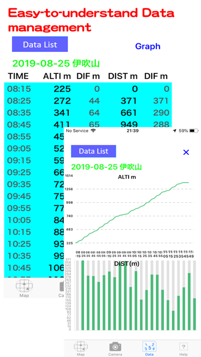
3. The name of the 'Read Data' button on the Data screen has been changed to 'Data List'. When the data list (saved file name) is displayed, this button is hidden. In addition, when the Data screen is opened immediately after starting the application, this data list is displayed.
The red pin annotation display introduced in version 5.2.0 has been modified to be completely compatible with previous data. Specifically, It was solved that the application falled when reading the data created before 5.1.0 and opening the map on the Map screen.
Modified to display the red pin annotation added in the previous version even during positioning.
On the map, in addition to the start mark 'S' and goal mark 'G', the rest mark 'R' is dropped at the position where positioning was paused. Also, 'Pause' and 'Resume' are displayed in a red pin balloon.
Positioning can now be paused when it is no longer necessary to update location information due to a break during positioning. This can save battery power.
Pressing the “STOP” button allows you to select “End”, “Continue”, or “Pause”. When paused, the “STOP” button will show “Resume”. Press the “Resume” button to continue positioning.
When searching a map on the Map screen, a problem that the map did not move to that location occurred in some environments. This phenomenon has been corrected.
Localization of the photograph button name in AR View and the completion button name after deleting data on the Data screen into Japanese was executed.