Created by John Craig Freeman with audio by Raul Reis, Virtual U.S./Mexico Border is a walk through augmented reality experience which allows users to immerse themselves in a virtual scene documenting the North American migration crisis.
The project includes an augmented reality scene produced on location where the border fence terminates into the Pacific Ocean at Playas de Tijuana in Mexico, north into Border Field State Park in the United States.
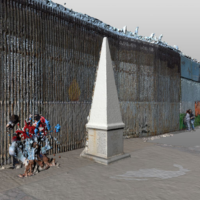
The virtual experience is centered on the historic obelisk boundary marker monument which commemorates the Treaty of Guadalupe Hidalgo that ended the war between the United States and Mexico on February 2, 1848 and transferred ownership of California, Arizona, New Mexico and Texas, from Mexico to the United States. The agreement provided that an international border between the two countries would be established by a joint United States and Mexican boundary survey. The commission began its survey work at Border Field at the very point where the obelisk is placed.
When launched, the app allows users to explore a full-scale 3D representation of this important location, and epicenter of U.S. migration policy.
Users can walk directly through the virtual border fence from one side to the other and listen to the stories found there.
Teleport directly to key locations by tapping the link.
Virtual U.S./Mexico Border is best viewed outdoors in a public space with ample room to walk around.
The best time to experience the project is the late afternoon or early evening when the light softens and screen glare is minimal.