Wigemo

Wigemo


Map (Manage your Places)


$2.99

1.9for iPhone, iPad and more
9.9
2 Ratings
Alexander Clauss
Developer
47.3 MB
Size
Jan 17, 2024
Update Date
Travel
Category
17+
Age Rating
Age Rating
4+
Apps in this category do not contain restricted content.
9+
Apps in this category may contain mild or occasional cartoon, fantasy or real-life violence, as well as occasional or mild adult, sexually suggestive or horrifying content and may not be suitable for children under 9 years of age.
12+
Apps in this category may contain occasional mild indecent language, frequent or intense cartoon or real-life violence, minor or occasional adult or sexually suggestive material, and simulated gambling, and may be for children under 12 years of age.
17+
You must be at least 17 years old to access this App.
Apps in this category may contain frequent and intense offensive language; Frequent and intense cartoon, fantasy or realistic violence: frequent and intense adult, scary and sexually suggestive subjects: as well as sexual content, nudity, tobacco, alcohol and drugs, may not be suitable for children under 17 years of age.
Wigemo Screenshots
Wigemo posterWigemo posterWigemo posterWigemo posterWigemo posterWigemo posterWigemo posterWigemo poster

About Wigemo

Wigemo is a Maps app with connection to Wikipedia for iPhone, iPod Touch, iPad and Apple Watch.

Save and manage your favorite places and locations, save the places you want to visit, plan your next vacation, manage the geo caches you've found or want to find, find sights and much more.

Thanks to the connection to Wikipedia, you can easily read the Wikipedia article for the places.

Import places from GPX, KML or CSV files, from photos, web sites, from Booking (App and Web), Google Maps, Apple Maps, Yelp...

The app can automatically notify you if you approach certain saved locations, so you won't miss them.
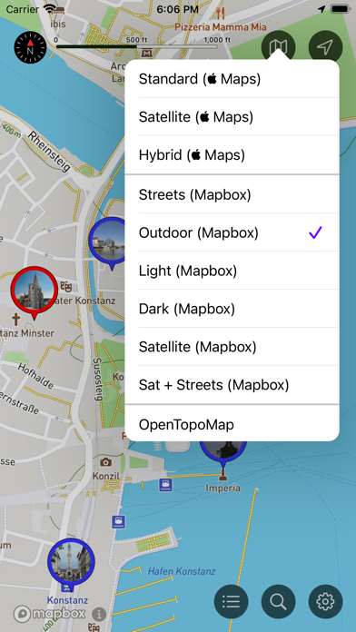

Supported Maps

- Apple Maps (Standard, Satellite, Hybrid, Flyover, 3D Buildings),
- OpenTopoMap (Topographical map)
- Mapbox Maps via additional subscription (Streets, Outdoors, Light, Dark, Satellite, Satellite+Street). These high-quality maps are much more detailed (especially in nature, hiking trails, paths, outdoor activity etc.)
- Any number of additional raster maps can be included via additional "tile server" features (with an additional one-time purchase)


Search

- POI search via Apple Maps
- Search via Wikipedia
- Search for search terms
- Search for coordinates
- Search for places nearby certain reference locations
- Filter search results by categories


Details for places

- Display Web page or Wikipedia article of the place
- Phone number (incl. option to call the number)
- Address
- Visited status
- Category
- Color (used for the pins on the map)
- photo


Manage Places

- Places can be saved in lists
- Move places from one list to another
- Show or hide lists and their places on the Map (so you can concentrate on those places you are currently interested in)
- Places can be show/hidden based on their "visited" status
- There are multiple styles available for the pins on the Map (a simple disc, icon of the category, photo, different sizes)


Import Places

- You can import geo locations from other Apps via "share" feature, via AirDrop, from cloud service, from the photo album, the address book
- Supports photos (with GPS coordinates), Web addresses, GPX, KML, and CSV files, geo coordinates
- Recognized are many web sites with geo tags, embedded google maps, the booking web site, Wikipedia, Yelp etc.
- Apps which can share suitable data are for example the Booking App, Apple-Maps, Web-Browser


Export Places

- Places can be exported as GPX, KML, or CSV file (individually, whole lists or even all lists at once)
- You can share the data with other Apps ur export them to cloud services
- iCloud Sync can be used to synchronize the places between multiple iOS devices
- You can also sync the places between iPhone and Apple Watch


Routes

- A route stores a path from A to B, including additional information and notes for waypoints
- Import routes from GPX/KML files
- Create routes manually
- Use the "directions" feature to create routes
- Save and organise any number or routes
- Display routes on the map


Other Features

- The App can send a notification if the user approaches saved places
- A crosshair with geo coordinates can be shown on the Map
- A scale allows to estamate distances on the map


Apple Watch

- The App on the Apple Watch supports the search via Wikipedia
- Places can be organized in lists
- Places can be shown/hidden on the map (based on lists, and visited status)
- Places can be saved on the watch
- The Watch App can run independently from the iPhone App.


Note: The App supports even older iOS releases back to iOS 12. But the full feature set requires iOS 14 and newer. Only search features relying on Apple's map services can be limited under iOS 12 or 13, the search via Wikipedia will work under all iOS releases. e.g. filtering search results by POI category requires at least iOS 13. The search for POIs near a certain location requires iOS 14 and later.


EULA: https://www.apple.com/legal/internet-services/itunes/dev/stdeula/
Show More

What's New in the Latest Version 1.9

Last updated on Jan 17, 2024
Old Versions
- The "directions" feature to get a route from A to B allows to define start (A) and destination (B) in any order now (before you always had to define the destination first)
- The "tile server" feature allows to export the server configuration as MapSource file now.
- Now, the App can also read "folders" defined in KML files. So when importing a KML file with multiple folders of places, the App is able to create corresponding folders in its own list of places and put the imported places there. However you can still import all the places into already existing folders. The App asks for the destination when importing KML files, so pick "Create new list" if you want to allow the creation of new folders.
- The KML import supports "routes" which are defined through a list of place marks.
- The new version does also sync custom POI categories including their icon which were defined while saving/editing places/locations (in case iCloud sync is enabled).
- Now, the App also runs on Macs with Apple Silicon processors. Because of a bug within the macOS this did not work before without crashes.
Show More
Version History
1.9
Jan 17, 2024
- The "directions" feature to get a route from A to B allows to define start (A) and destination (B) in any order now (before you always had to define the destination first)
- The "tile server" feature allows to export the server configuration as MapSource file now.
- Now, the App can also read "folders" defined in KML files. So when importing a KML file with multiple folders of places, the App is able to create corresponding folders in its own list of places and put the imported places there. However you can still import all the places into already existing folders. The App asks for the destination when importing KML files, so pick "Create new list" if you want to allow the creation of new folders.
- The KML import supports "routes" which are defined through a list of place marks.
- The new version does also sync custom POI categories including their icon which were defined while saving/editing places/locations (in case iCloud sync is enabled).
- Now, the App also runs on Macs with Apple Silicon processors. Because of a bug within the macOS this did not work before without crashes.
1.8
Jan 26, 2023
- "Map Overlays" do now support the MapBox maps as well. Which means this feature can be now used with all maps styles and map types without any restrictions.

- Under iOS 16 and later it is now also possible to customize the colors/contrast of the Standard Apple Maps to make it more vivid easier to read. Other Map properties, like pitch, traffic etc. can be configured individually for each of the Apple Map styles.

- The App can now also calculate routes/directions between two random locations, in the past the start locations was always the current location of the user.

- Bugfix: When sharing a contact to the App the Sharesheet of Wigemo did not show the actual coordinates of the address in the preview (though saving the address did work correctly, including the coordinates)

- Bugfix: The compass in the dynamic island was slightly too big since iOS 16.2, so the top and bottom border was cut off.
1.7
Oct 19, 2022
- Since iOS 16.1 the App supports "Live Activities" on the iPhone. The compass which shows the direction and distance to a place or location will be now moved to the dynamic island (iPhone 14 Pro) and the lock screen (all iPhones) when leaving the App while the compass is open. If you don't need this live activities feature, you can also switch it off in the settings of the App.

- There are a few new option in the settings to remove items you don't need from the menu for the locations

- Bugfix: When syncing routes via iCloud it could happen that these were not immediately updated on the map.
1.6
Sep 29, 2022
- Improved support for "Look Around" (since iOS 16).
- it is now possible to activate "Look Around" using the "locate" icon (top right) for the current location
- "Look Around" can be activated for routes (start and destination) as well.
- The preview window for the "Look Around" feature will now stay open unless closed via its close button.
- Tapping the preview window will open "Look Around" in fullscreen.
- The preview window of "Look Around" can be moved to any of the corners of the screen using swipe gestures.
- Selecting any pin (location, waypoint of a route, etc), and opeing a location or place from the list of saved places or from search results will automatically update the preview window and shows the selected location there.
- It is possible to switch off the "Look Around" feature completely in the settings, for example if this feature is not available in your area. This will also remove all "Look around"-related menu items from all menus, to keep them smaller.

- When iCloud sync is enabled the App will now also sync all the configured tile servers.

1.5
Sep 23, 2022
- Since iOS 16 you can also use the "Look around" feature directly within the App. Activate this feature from within the menu of a location or place.

- A new option for the Apple map styles allows to change the angle (pitch) you look on the map. This will also enable the "Flyover" views (satellite, hybrid maps styles) and 3D buildings (standard map styles).

- The App also supports the "muted" standard Apple map style. This map style uses less saturated colors and less contrast, so that all the additional information (pins) stands out more.

- The App is now able to create and store routes (paths from A to B). You can create routes completely manually, but also import these from GPX or KML files (which include routes or tracks), or use the directions feature which shows a route from the current location to a saved location of place.

- The App icon on the homepage has a new menu (when long-pressed) which allows to launch the App and directly activate certain features.

- The notifications feature which notifies you when you approach certain locations is now able to filter by visited state.

- The App is now using a separate menu for map overlays (if available), so these can be enabled/disabled much easier.

- The "location" symbol at the top right corner can be now double-clicked, which will directly center the map to the current location. A normal tap will still open the menu with all the available options.

- The search can be optional restricted to the visible map region now.

- Abbreviated PlusCodes which include the name of a town or region are now supported as well for the search feature.

- While importing locations and places from files, images and contacts it is now possible to directly create new lists and also change the default lists form future imports. It's no longer necessary to do this in the location list window or in the settings.


- Improved performance when using the Apple map styles and any of the additional configured raster maps when a huge number of pins with photos are shown on the map at the same time.

- Bugfix: Fixes an issue when changing the max/min zoom for raster map servers, which falsely change the name as well.


1.4
Jun 5, 2022
New Features:
-------------

- In the detail view of a place (e.g. when editing or saving a place) when selecting the list in which the location should be stored, it is now possible to directly create, edit or delete the lists here as well.

- In the detail view of a place when selecting a category, it's now possible to create your own custom categories as well (requires iOS 14 or newer).

- The "Tile Server" option does now also support "overlays". There are tile servers which do no provide full maps but instead only overlays with additional information wich should be displayed on top of existing maps. Wigemo can make these Overlays available for all three Apple Maps and also all Raster Maps. When selecting a map from the list of available Maps, a new "layer" icon will indicate that Overlays are available for the maps and tapping this icon lets you select and activate an overlay on this map.


Improvements:
-------------

- Sharing places from the Yelp App to Wigemo is now supported.

- Sharing places from the Google Maps App to Wigemo is now supported as well

- The App for the Apple Watch is now able to show web sites of places without the "warning" that was shown by the watchOS in previous releases.

- In case many images had to be loaded at the same time, the App is now more smooth.


Bugfixes:
---------

- Bugfix: When exchanging the photo of a place, the new photo was not always shown in the pin on the map immediately

- Bugfix: Exchanging the photo of a place failed if the new photo didn't include geo coordinates

- Bugfix: The GPS coordinates in EXIF information of photos were interpreted wrong in case the coordinates were not given in the standard conventions (e.g. positive values mean north or east, negative values south or west)
1.3
Apr 22, 2022
- Adds a new "Compass" feature for all places in their menu which will show a big compass which also shows an arrow pointing in the direction of the selected place and the distance and the current speed of travel. It also shows the current coordinates.
- Adds support for "Plus Codes" when displaying or searching for coordinates.
- Some additional minor improvements
1.2
Mar 28, 2022
- The Export feature supports many new data formats for places: Adresses for Apple Maps, Google Maps and Bing Maps. Also locations can be exported as QR code

- The Import feature of the App supports some new data types: Adresses for Apple Maps, Google Maps and Bing Maps, also also VCARDs

- Using the "pen" icon within the places lists it is now possible to sort the places (by name, tag/color, category, distance)

- In addition you can change the visited status, the tag/color and the category of all the places in the list at once.

- A new option in the settings allows to configure if the details within the lists and "callout" views for places show the address or the optional user-defined description.

- The App provides many new categories which can be assigned to the saved places. There's also a new search feature for the categories (scroll to the very top to reveal the search field) to make it more easy to find categories.

- The search via Apple Maps API (search for POIs) is improved and is able to finds more places. This search is now also available on devices with the older iOS 12.

- On the Apple Watch it is now possible to show all search results on the map as red pins. These pins can be tapped and inspected and saved easily.
1.1.1
Feb 15, 2022
- The description field for a place in the details window is now a multi-line text field, which makes it easier to enter a longer description.
- The App can now also import google maps, Apple Maps and Bing maps URLs.
- Improves the Import of various file formats
- Fixes a bug in the iCloud sync feature where photos which were replaced by others were not always synced to the other devices.
1.1
Feb 5, 2022
- Adds support for "geo:" URLs (for sharing, export, and also for launching the App)
- Adds a new option to have square pins/annotations on the map instead of only round ones (useful for pins with photos where more of the photo can be shown)
- Adds a new option to show the photo that is assigned to a location in full screen mode
- Adds an option to configure the maximum size for photos that are imported. Larger photos will be scaled down to save space.
- Adds a few new export options
- Fixes a few glitches within the user interface where menus could be too small under certain circumstances
- Fixes a crash when copying coordinates for locations which are not yet saved
- Fixes an issue when importing multiple photos at once from within the import feature of the settings
1.0
Jan 30, 2022

Wigemo FAQ

Click here to learn how to download Wigemo in restricted country or region.
Check the following list to see the minimum requirements of Wigemo.
iPhone
Requires iOS 12.0 or later.
iPad
Requires iPadOS 12.0 or later.
Apple Watch
Requires watchOS 4.0 or later.
iPod touch
Requires iOS 12.0 or later.
Wigemo supports English, German
Wigemo contains in-app purchases. Please check the pricing plan as below:
Mapbox Subscription (1 Month)
$0.49
Map Tile Server Feature
$1.99
Mapbox Subscription (1 Year)
$3.49
Mapbox Subscription (6 Month)
$2.49

Wigemo Alternative

You May Also Like

Get more from Alexander Clauss