Alberta Rivers
Data and Advisories
Gratis
3.6.1for iPhone, iPad and more
Age Rating
لقطات الشاشة لـ Alberta Rivers
About Alberta Rivers
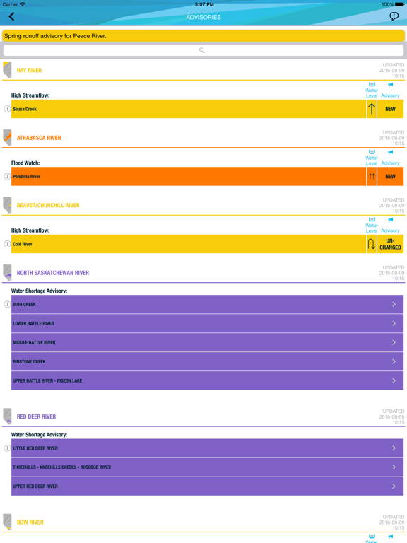
Obtain the latest information about Alberta’s rivers, including low flow advisories, flood advisories, ice jam advisories and comments issued by Alberta’s River Forecast Centre. View all current surface water data for Alberta.
Features:
- View all monitoring stations on a map.
- Tap stations to view current data and whether flows are low, normal or high.
- Receive notifications when new advisories and comments are issued.
- Save your own list of important stations for quick reference.
Features:
- View all monitoring stations on a map.
- Tap stations to view current data and whether flows are low, normal or high.
- Receive notifications when new advisories and comments are issued.
- Save your own list of important stations for quick reference.
Show More
تحديث لأحدث إصدار 3.6.1
Last updated on 08/03/2024
الإصدارات القديمة
1. Corrected shapefiles on the map
2. Updated Ice conditions colors on the map and screens.
Show More
Version History
3.6.1
08/03/2024
1. Corrected shapefiles on the map
2. Updated Ice conditions colors on the map and screens.
3.6.0
07/11/2023
Reliability improvements
3.5.0
05/07/2023
Includes changes to sort the advisories section by display-order on Advisories screen.
3.4.1
11/01/2023
Title bars were modified in app screens to follow a consistent format.
The basins table, that is displayed on Advisories screen, was changed to display the requested sort order.
Privacy-location information was updated.
The basins table, that is displayed on Advisories screen, was changed to display the requested sort order.
Privacy-location information was updated.
3.3.1
31/03/2022
- Added new high flow polyline feature
- Added 'view' functionality to advisory list
- Advisories now apply to redesigned sub basin map
- High flow advisories now populate in the ticker
- New miniature map icons for some basins added
- Added 'view' functionality to advisory list
- Advisories now apply to redesigned sub basin map
- High flow advisories now populate in the ticker
- New miniature map icons for some basins added
3.2.1
27/07/2019
- Fix misc crashes
- Fix duplicated stations
- Fix logo placement
- Fix for pins not separating
- Add new Ice Run help image
- Fix duplicated stations
- Fix logo placement
- Fix for pins not separating
- Add new Ice Run help image
3.1
17/05/2018
This release includes bug fixes, performance improvements, and refinements in the data and information display, including display of:
- additional advisory basins (e.g., Swan Hills);
- capacities at all reservoirs where available; and
- Forecaster Comments in the Advisory ticker.
- additional advisory basins (e.g., Swan Hills);
- capacities at all reservoirs where available; and
- Forecaster Comments in the Advisory ticker.
3.0.5
10/08/2016
Bug fixes.
3.0.4
29/07/2016
Bug fixes.
3.0.2
23/06/2016
Water Management Data and Water Shortage Advisories have been added in a new tab on the main map screen.
During periods of low flow users will be able to determine if there are restrictions on angling, temporary diversions or water withdrawals in their area and throughout the province.
Users can subscribe to receive push notification when flows are approaching or below water management thresholds for select stations.
Water Management reports have been added to select stations.
3.0.1
10/06/2016
Water Management Data and Water Shortage Advisories have been added in a new tab on the main map screen.
During periods of low flow users will be able to determine if there are restrictions on angling, temporary diversions or water withdrawals in their area and throughout the province.
Users can subscribe to receive push notification when flows are approaching or below water management thresholds for select stations.
Water Management reports have been added to select stations.
During periods of low flow users will be able to determine if there are restrictions on angling, temporary diversions or water withdrawals in their area and throughout the province.
Users can subscribe to receive push notification when flows are approaching or below water management thresholds for select stations.
Water Management reports have been added to select stations.
2.0.1
23/05/2015
Updates:
- Portrait and Landscape views are supported.
- Submit photo feature allows users to upload photos of river conditions directly to forecasters.
- Both water levels and flow are now displayed for river stations.
- Guided tutorial on app features during first use.
- Portrait and Landscape views are supported.
- Submit photo feature allows users to upload photos of river conditions directly to forecasters.
- Both water levels and flow are now displayed for river stations.
- Guided tutorial on app features during first use.
1.0
19/06/2014
Alberta Rivers FAQ
انقر هنا لمعرفة كيفية تنزيل Alberta Rivers في بلد أو منطقة محظورة.
تحقق من القائمة التالية لمعرفة الحد الأدنى من المتطلبات Alberta Rivers.
iPhone
Requiere iOS 13.0 o posterior.
iPad
Requiere iPadOS 13.0 o posterior.
iPod touch
Requiere iOS 13.0 o posterior.
Alberta Rivers هي مدعومة على اللغات Inglés