Added: up to 5 minutes of pause time at each waypoint.
Improved: Virtual stick point-of-interest yaw algorithm. Results in smoother drone heading changes.
Fixed: Defect when drones report invalid coordinates on startup and the app crashes.
Added support for:
* DJI Mini 2 (vitual stick missions only)
* DJI Mini SE (virtual stick missions only)
* DJI Air 2S (virtual stick missions only)
Improvements for virtual stick waypoint missions.
Added: Virtual stick point-of-interest waypoint missions
Fixed: Minor display issue with waypoint editor for POI waypoints
Updated: DJI SDK v4.15.2
Fixed: defect when tapping on the add waypoint icon '+'
Updated: DJI SDK v4.15.1
Improved: Waypoint editor, general waypoint editing improvements.
Updated: DJI SDK to v4.15
Updated: Preflight checklist starts tracking status faster
Updated: Preflight checklist altitude and distance edit inputs are working
Updated: Virtual Stick Waypoint Missions update frequency has been improved
Added: New drone and home point markers
Added: Virtual stick waypoint missions
Added: Mavic Mini support
Added: Mavic Air 2 support
Improved: Camera Settings
Improved: UI layout and spacing for waypoint settings
Added: confirmation boxes when deleting flight plans
Added: confirmation box when starting fail safe mode Go Home.
Added: Mavic Mini support
Added: Virtual stick waypoint missions for the Mavic Mini
Fixed: Camera settings
Updated: App Store profile
Supported Drones:
* Mavic Mini (coming soon, contact brad@beyondthecube.ca for early access)
* Matrice 300 RTK
* DJI X-Port
* DJI SkyPort
* DJI SkyPort V2
* Matrice 200 V2
* Matrice 210 V2
* Matrice 210 RTK V2
* Phantom 4 RTK
* Mavic 2 Enterprise, Mavic 2 Enterprise Dual
* Mavic 2 Pro
* Mavic 2 Zoom
* Spark
* Matrice 210
* Matrice 210RTK
* Matrice 200
* Inspire 2
* Mavic Pro
* Mavic Air
* Phantom 4, Phantom 4 Pro & Phantom 4 Advanced, Phantom 4 Pro V2.0, P4
* Matrice 600 & Matrice 600 Pro, RTK and Ronin MX
* Phantom 3 Standard, Advanced, 4K & Professional
* Inspire 1, Inspire 1 Pro & Inspire 1 RAW
* Matrice 100 with X3, X5 & X5R
Updated: App Store profile
Fixed: Minor preflight checklist defects
Fixed: Dark mode text issues
Supported Drones:
* Mavic Mini (no waypoint missions)
* Matrice 300 RTK
* DJI X-Port
* DJI SkyPort
* DJI SkyPort V2
* Matrice 200 V2
* Matrice 210 V2
* Matrice 210 RTK V2
* Phantom 4 RTK
* Mavic 2 Enterprise, Mavic 2 Enterprise Dual
* Mavic 2 Pro
* Mavic 2 Zoom
* Spark
* Matrice 210
* Matrice 210RTK
* Matrice 200
* Inspire 2
* Mavic Pro
* Mavic Air
* Phantom 4, Phantom 4 Pro & Phantom 4 Advanced, Phantom 4 Pro V2.0, P4
* Matrice 600 & Matrice 600 Pro, RTK and Ronin MX
* Phantom 3 Standard, Advanced, 4K & Professional
* Inspire 1, Inspire 1 Pro & Inspire 1 RAW
* Matrice 100 with X3, X5 & X5R
Updated: App Store profile
Fixed: Dark mode text issues
Added: Mirror option for grid flights
Added: Coverage option for grid flights
Improved: Start fight window, start and abort buttons are larger
Improved: Camera start/stop intervals for grid flights
Added: OpenStreetMap base layer
Supported Drones:
* Mavic Mini (no waypoint missions)
* Matrice 300 RTK
* DJI X-Port
* DJI SkyPort
* DJI SkyPort V2
* Matrice 200 V2
* Matrice 210 V2
* Matrice 210 RTK V2
* Phantom 4 RTK
* Mavic 2 Enterprise, Mavic 2 Enterprise Dual
* Mavic 2 Pro
* Mavic 2 Zoom
* Spark
* Matrice 210
* Matrice 210RTK
* Matrice 200
* Inspire 2
* Mavic Pro
* Mavic Air
* Phantom 4, Phantom 4 Pro & Phantom 4 Advanced, Phantom 4 Pro V2.0, P4
* Matrice 600 & Matrice 600 Pro, RTK and Ronin MX
* Phantom 3 Standard, Advanced, 4K & Professional
* Inspire 1, Inspire 1 Pro & Inspire 1 RAW
* Matrice 100 with X3, X5 & X5R
Added: Mirror option for grid flights
Added: Coverage option for grid flights
Improved: Start fight window, start and abort buttons are larger
Improved: Camera start/stop intervals for grid flights
Added: OpenStreetMap base layer
Supported Drones:
* Mavic Mini
* Matrice 300 RTK
* DJI X-Port
* DJI SkyPort
* DJI SkyPort V2
* Matrice 200 V2
* Matrice 210 V2
* Matrice 210 RTK V2
* Phantom 4 RTK
* Mavic 2 Enterprise, Mavic 2 Enterprise Dual
* Mavic 2 Pro
* Mavic 2 Zoom
* Spark
* Matrice 210
* Matrice 210RTK
* Matrice 200
* Inspire 2
* Mavic Pro
* Mavic Air
* Phantom 4, Phantom 4 Pro & Phantom 4 Advanced, Phantom 4 Pro V2.0, P4
* Matrice 600 & Matrice 600 Pro, RTK and Ronin MX
* Phantom 3 Standard, Advanced, 4K & Professional
* Inspire 1, Inspire 1 Pro & Inspire 1 RAW
* Matrice 100 with X3, X5 & X5R
Added: OpenStreetMap base layer
Update: DJI SDK 4.13.1
Add: Flight Plan downloads/uploads (csv format)
New Supported Drones:
* Mavic Mini
* Matrice 300 RTK
* DJI X-Port
* DJI SkyPort
* DJI SkyPort V2
* Matrice 200 V2
* Matrice 210 V2
* Matrice 210 RTK V2
* Phantom 4 RTK
* Mavic 2 Enterprise, Mavic 2 Enterprise Dual
* Mavic 2 Pro
* Mavic 2 Zoom
* Spark
* Matrice 210
* Matrice 210RTK
* Matrice 200
* Inspire 2
* Mavic Pro
* Mavic Air
* Phantom 4, Phantom 4 Pro & Phantom 4 Advanced, Phantom 4 Pro V2.0, P4
* Matrice 600 & Matrice 600 Pro, RTK and Ronin MX
* Phantom 3 Standard, Advanced, 4K & Professional
* Inspire 1, Inspire 1 Pro & Inspire 1 RAW
* Matrice 100 with X3, X5 & X5R
Update: DJI SDK 4.13.1
New Supported Drones:
* Mavic Mini
* Matrice 300 RTK
* DJI X-Port
* DJI SkyPort
* DJI SkyPort V2
* Matrice 200 V2
* Matrice 210 V2
* Matrice 210 RTK V2
* Phantom 4 RTK
* Mavic 2 Enterprise, Mavic 2 Enterprise Dual
* Mavic 2 Pro
* Mavic 2 Zoom
* Spark
* Matrice 210
* Matrice 210RTK
* Matrice 200
* Inspire 2
* Mavic Pro
* Mavic Air
* Phantom 4, Phantom 4 Pro & Phantom 4 Advanced, Phantom 4 Pro V2.0, P4
* Matrice 600 & Matrice 600 Pro, RTK and Ronin MX
* Phantom 3 Standard, Advanced, 4K & Professional
* Inspire 1, Inspire 1 Pro & Inspire 1 RAW
* Matrice 100 with X3, X5 & X5R
Fix waypoint settings layout issue in iOSv13
Added: OpenTopoMap © OpenStreetMap-Mitwirkende, SRTM | Kartendarstellung: © OpenTopoMap (CC-BY-SA)
Removed: Unimportant startup user messages
Improved: App max distance messages on startup
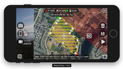
OpenTopoMap is a free, topographic map, and it is now integrated into Flight Plan for DJI, v4.11. If you are flying in areas with elevation changes this map can help you plan and verify missions. The map displays detailed city, road, and building information and includes coloured elevation data and contour lines. A contour line is a line connecting places of equal elevation. OpenTopoMap displays contour lines showing elevation changes of 10 meters.
Flight Plan is currently using the free OpenTopoMap server which limits the number of map tiles you can download in a specific period of time. For optimal use pan/zoom around using one of the existing base maps then switch to the topographic map to see elevation data for a particular location.
V4.11 supports:
Matrice 200 V2
Matrice 210 V2
Matrice 210 RTK V2
Phantom 4 RTK
Mavic 2 Enterprise, Mavic 2 Enterprise Dual
Mavic 2 Pro
Mavic 2 Zoom
Spark with remote
Matrice 210
Matrice 210RTK
Matrice 200
Inspire 2
Mavic Pro
Mavic Air
Phantom 4, Phantom 4 Pro & Phantom 4 Advanced, Phantom 4 Pro V2.0
Matrice 600 & Matrice 600 Pro, RTK and Ronin MX
Phantom 3 Standard, Advanced, 4K & Professional
Inspire 1, Inspire 1 Pro & Inspire 1 RAW
Matrice 100 with X3, X5 & X5R
Lightbridge 2 with A2
Lightbridge 2 with standalone A3 or N3
Focus
N1 Video Encoder
Cendence
N3, A3, A2
Added: OpenTopoMap © OpenStreetMap-Mitwirkende, SRTM | Kartendarstellung: © OpenTopoMap (CC-BY-SA)
Removed: Unimportant startup user messages
Improved: App max distance messages on startup
OpenTopoMap is a free, topographic map, and it is now integrated into Flight Plan for DJI, v4.11. If you are flying in areas with elevation changes this map can help you plan and verify missions. The map displays detailed city, road, and building information and includes coloured elevation data and contour lines. A contour line is a line connecting places of equal elevation. OpenTopoMap displays contour lines showing elevation changes of 10 meters.
Flight Plan is currently using the free OpenTopoMap server which limits the number of map tiles you can download in a specific period of time. For optimal use pan/zoom around using one of the existing base maps then switch to the topographic map to see elevation data for a particular location.
V4.11 supports:
Matrice 200 V2
Matrice 210 V2
Matrice 210 RTK V2
Phantom 4 RTK
Mavic 2 Enterprise, Mavic 2 Enterprise Dual
Mavic 2 Pro
Mavic 2 Zoom
Spark with remote
Matrice 210
Matrice 210RTK
Matrice 200
Inspire 2
Mavic Pro
Mavic Air
Phantom 4, Phantom 4 Pro & Phantom 4 Advanced, Phantom 4 Pro V2.0
Matrice 600 & Matrice 600 Pro, RTK and Ronin MX
Phantom 3 Standard, Advanced, 4K & Professional
Inspire 1, Inspire 1 Pro & Inspire 1 RAW
Matrice 100 with X3, X5 & X5R
Lightbridge 2 with A2
Lightbridge 2 with standalone A3 or N3
Focus
N1 Video Encoder
Cendence
N3, A3, A2
Actualizado: DJI SDK a la versión 4.10
Soporte agregado para Drones:
* Soporte Matrice 200 Series V2
* Soporte Phantom 4 RTK
* Soporte Mavic 2 Enterprise Dual
Añadir: ajustes de exposición de la cámara
Mejorado: configuración de la cámara
Mejorado: los colores de la zona de vuelo no coinciden con los colores DJI
Mejorado: los nombres de los planes de vuelo locales están ordenados alfabéticamente
Mavic 2 Pro/Zoom/Enterprise FPV support