Radius on Map Full Version
$5.99
2.8for iPhone, iPad and more
Age Rating
Radius on Map Full Version Capturas de tela
About Radius on Map Full Version
Easily make a radius on a map and share a url showing the radius via email or text message that can be viewed with any browser.
Extra functionality of the full version includes:
- Lock a radius center to your current location.
- Support for landscape and iPad split screen.
- Share multiple radii in one url.
- Import radii stored as polygons in a .kml or .kmz file. You can import a file from a cloud service such as iCloud or Dropbox.
- Export your radii as polygons saved to a kml file to view in Google Earth™ or other mapping applications. You can attach the .kml file to an email or save to iCloud, Dropbox, etc.
- Ability to specify which radii show on the map by selecting them in the list view.
- Search for keywords in name and/or notes field to find a specific radius.
- Custom message header and footer.
- No adverts
Properties for each radius:
- Center coordinate
- Radius
- Fill color and opacity
- Perimeter color and opacity
- Name
- Notes (optional)
Coordinate formats include:
- Degrees
- Degrees, Minutes
- Degrees, Minutes, Seconds
- UTM (Universal Transverse Mercator)
- MGRS (Military Grid Reference System)
Distance units include:
- Kilometers
- Miles
- Nautical miles
- Meters
- Yards
- Feet
Loading satellite maps requires an internet connection.
Datum used is WGS-84.
Please visit the support page for more details.
Show More
Novidades da Última Versão 2.8
Last updated on Aug 1, 2022
Versões Antigas
Compatibility fix for newer iOS versions.
Please send crash reports if crashes occur.
Please contact the developer via email if you have questions or notice any errors or issues.
Please send crash reports if crashes occur.
Please contact the developer via email if you have questions or notice any errors or issues.
Show More
Version History
2.8
Aug 1, 2022
Compatibility fix for newer iOS versions.
Please send crash reports if crashes occur.
Please contact the developer via email if you have questions or notice any errors or issues.
Please send crash reports if crashes occur.
Please contact the developer via email if you have questions or notice any errors or issues.
2.7
Sep 10, 2020
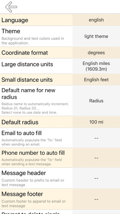
- Pin color can be changed.
- Better support for dark theme and new devices.
- Minor interface and layout changes.
- Define icon for kml export to preserve pin color when exporting to other applications.
Please send crash reports if crashes occur.
Please contact the developer via email if you have questions or notice any errors or issues.
2.6
May 30, 2020
- Several error corrections and interface adjustments
- Better multilingual support
Please send crash reports if crashes occur.
Please contact the developer via email if you have questions or notice any errors or issues.
- Better multilingual support
Please send crash reports if crashes occur.
Please contact the developer via email if you have questions or notice any errors or issues.
2.5
Jan 28, 2020
Bug fixes from last update:
- Fixed map link URL
- Fixed MGRS Easting/Northing overflow
- Changed latitude, longitude representation back to '.' decimal separator.
Please contact the developer via the in-app email form if you notice any issues.
- Fixed map link URL
- Fixed MGRS Easting/Northing overflow
- Changed latitude, longitude representation back to '.' decimal separator.
Please contact the developer via the in-app email form if you notice any issues.
2.4
Jan 24, 2020
Bug fixes from last update:
- Fix map link URL
- Fix MGRS Easting/Northing overflow
- Change latitude, longitude representation back to '.' decimal separator.
Please contact the developer via the in-app email form if you notice any issues.
- Fix map link URL
- Fix MGRS Easting/Northing overflow
- Change latitude, longitude representation back to '.' decimal separator.
Please contact the developer via the in-app email form if you notice any issues.
2.3
Jan 2, 2020
- Better support for iOS 13 and newer devices.
- With iOS 13, the in-app light or dark theme now defaults to the device preference. You can still set this in the app settings to ignore device preference.
- Improved colors for dark theme.
- Added UTM and MGRS coordinate formats (WGS-84)
- Added UTM and MGRS map gridlines and neatlines according to U.S. Department of Defense recommendations.
- Removed support for iOS 8. Minimum is now iOS 9.
Please see the help page for details.
2.2
Feb 28, 2018
- Added support for landscape and iPad split screen.
- Corrected a bug that was introduced in the December update where editing some of a radii's properties would not trigger a refresh on the map. Thanks to Neil from Australia for pointing that out.
- Many low-level UI changes.
Supporting all layouts required significant back-end changes. Please report any issues that may have been introduced by emailing the developer.
1.37
Dec 11, 2017
December 2017:
- Added undo / redo functionality for important actions such as move, delete, bulk select, import kml. The undo / redo options, if any, appear near the bottom of the menu popup.
- The search function on the list page works differently. Instead of hiding the items that do not match your search terms, now the bits matching your search terms are highlighted.
- 'Save' and 'Share' on the list page now show up to 4 options to better control which radii to export.
- Added preference setting ‘hide status bar’ that defaults to No.
- Added preference setting ‘confirm delete of single radius’ that defaults to Yes. The undo / redo renders it somewhat redundant.
- Corrected color in the kml export. (The red and blue components were swapped)
- Minor layout changes.
- Significant back-end changes that were necessary for the new features.
- A few changes for iOS 11.
Please see the support page for details.
Note that a Mac version is now available. (There is a link in the app that appears on the menu popup about 30% of the time)
Please report any problems or bugs to the developer via email.
1.36
Aug 4, 2017
August, 2017 update:
Important fix for a long term bug that was recently discovered. If you have used the DMS (Degrees, Minutes, Seconds) format to save a radius, some error was introduced. There is a way to 'undo' this error in most cases. Please see the help page for details.
Bug fix for user-entered empty strings causing crash on settings page.
Several other minor changes explained on the help page.
Please report any problems or bugs to the developer via email.
1.35
Aug 1, 2017
August, 2017 update:
Important fix for a long term bug that was recently discovered. If you have used the DMS (Degrees, Minutes, Seconds) format to save a radius, some error was introduced. There is a way to 'undo' this error in most cases. Please see the help page for details.
Several other minor changes explained on the help page.
1.34
Jul 21, 2017
July, 2017 update:
Bug fixes and minor layout changes.
Please see the help page for details.
Please report any problems or bugs to the developer via email.
Bug fixes and minor layout changes.
Please see the help page for details.
Please report any problems or bugs to the developer via email.
1.33
Feb 22, 2017
Removed the GPS requirement to allow availability to WIFI-only iPad models that do not have a GPS receiver.
1.32
Jan 8, 2017
Major update. Please see the support page for more details.
Please report any problems or bugs to the developer via email.
1.31
Jul 31, 2015
bug fix
1.24
Jun 23, 2015
corrected a few errors.
1.05
May 31, 2015
Radius on Map Full Version FAQ
Radius on Map Full Version está disponível fora dos seguintes países restritos:
Brazil,Turkey
Radius on Map Full Version suporta English, Czech, Danish, Dutch, Finnish, French, German, Greek, Hungarian, Indonesian, Italian, Japanese, Korean, Malay, Norwegian Bokmål, Polish, Portuguese, Romanian, Russian, Simplified Chinese, Slovak, Spanish, Swedish, Thai, Traditional Chinese, Turkish, Ukrainian, Vietnamese
Clique aqui para saber como baixar Radius on Map Full Version em um país ou região restrita.
Confira a lista a seguir para ver os requisitos mínimos de Radius on Map Full Version.
iPhone
Requires iOS 9.0 or later.
iPad
Requires iPadOS 9.0 or later.
iPod touch
Requires iOS 9.0 or later.