Live traffic reports and cameras for British Columbia including Vancouver. Save your favorite cameras for quick access. The app was updated during January 2023.
KEY FEATURES:
Live data from The British Columbia Ministry of Transportation and Infrastructure:
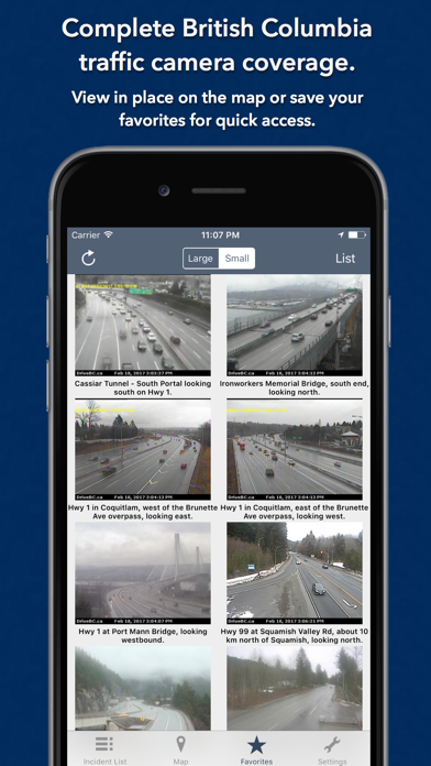
- 873 traffic cameras
- Today screen widget to show at a glance the nearest current traffic incidents
- Dark Mode throughout the app (iOS13+).
- Sharing: you can easily share traffic camera images with your Twitter followers, Facebook friends or via email etc.
- Optimised for all iPhone and iPad models.
MAP VIEW
- Shows current incidents and traffic cams
- Each incident is color coded as well as being represented by an icon showing the incident type.
- Clicking on an incident displays more detail right there on the map.
- The map view can also show live traffic camera images.
LIST VIEW
- Shows current incidents in order of distance from your current location (closest incidents are shown first).
- Each incident is color-coded to indicate the severity of the delay.
- You can quickly see the distance the incident is from you, the road name and the type of incident.
- The detail view shows the description together with a map showing the location.
- Full search functionality, works across both the list and map views.
TRAFFIC CAM FAVORITES
- Save your favorite cameras for quick access to see how clear/congested your usual routes are.
TODAY WIDGET
- Shows at a glance the nearest current traffic incidents without launching the app.
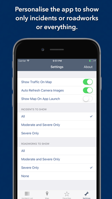
PERSONALISE
- Toggle traffic information on the map.
- Toggle auto refresh of camera images (will refresh every 10 seconds).
- Toggle always show map on app launch.
- Toggle roadworks on/off.
- You can configure which incidents are displayed according to the severity of the delay caused.
- Kilometres or Miles setting.
CONTACT
- Email me for feature requests/bug reports etc. I would love to hear from you!
Data courtesy of The British Columbia Ministry of Transportation and Infrastructure.