SeaNav

SeaNav


Marine Charts and Navigation


GratisOffers In-App Purchases

5.4.6for iPhone, iPad and more
8.5
188 Ratings
Pocket Mariner Ltd.
Developer
76,7 MB
Size
Mar 28, 2024
Update Date
Navigation
Category
4+
Age Rating
Age Rating
4+
Apps in this category do not contain restricted content.
9+
Apps in this category may contain mild or occasional cartoon, fantasy or real-life violence, as well as occasional or mild adult, sexually suggestive or horrifying content and may not be suitable for children under 9 years of age.
12+
Apps in this category may contain occasional mild indecent language, frequent or intense cartoon or real-life violence, minor or occasional adult or sexually suggestive material, and simulated gambling, and may be for children under 12 years of age.
17+
You must be at least 17 years old to access this App.
Apps in this category may contain frequent and intense offensive language; Frequent and intense cartoon, fantasy or realistic violence: frequent and intense adult, scary and sexually suggestive subjects: as well as sexual content, nudity, tobacco, alcohol and drugs, may not be suitable for children under 17 years of age.
SeaNav Screenshots
SeaNav PlakatSeaNav PlakatSeaNav PlakatSeaNav PlakatSeaNav PlakatSeaNav PlakatSeaNav PlakatSeaNav Plakat

About SeaNav

Erkunden, planen und navigieren Sie Ihre Bootsfahrten in Echtzeit und in hervorragender hoher Auflösung mit digitalen Karten, die aus den neuesten Daten des Hydrographischen Amtes abgeleitet wurden und eine Abdeckung in den USA und Europa bieten (USA, CA, UK & IE, DE, FR, NL, BE, DK, NEIN, ES, HR,PT). Rasterkarten für US, NZ, FI & EE.

- Vektorkarten - alle Bojen, Lichter etc. sind antippbar
- Nahtloses schnelles Schwenken und Zoomen über Diagramme hinweg
- Routenplanung und Echtzeitverfolgung
- North up- und Course up-Anzeigen
- Offline-Diagramme
- Konfigurierbare Ebenen
- Eingebauter Tutorial-Modus mit allen Funktionen, einschließlich Karten, AIS, AR und Wind
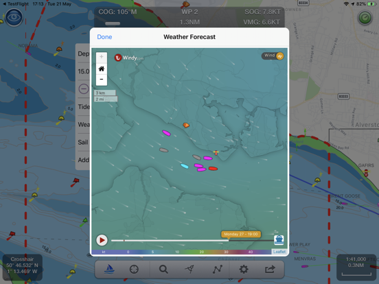
- Gezeiten, Bäche und Wetter
- Live-AIS-Schiffspositionen und Kollisionsalarm (IAP)
- Importieren und teilen Sie Routen und POIs im GPX- und KML-Format per E-Mail und Dropbox
- Live-Augmented-Reality-Kameraansicht (IAP) plus FLIRONE®-Nachtsichtunterstützung.
- Inklusive kostenloser Apple Watch App mit Navigations-, Wegpunkt-, Wind- und AIS-Gesichtern.
- NMEA-Tiefe, Windgeschwindigkeit und -richtung
- Lokale Windeinspeisung in Echtzeit (IAP)

Die kostenlose Version enthält alle Navigations- und Reiseplanungstools. Hochauflösende Vektorkarten sind per In-App-Kauf (IAP) inklusive Updates für 12 Monate erhältlich.

Vektorkarten bieten viele Vorteile gegenüber herkömmlichen Rasterkarten. Bojen, Lichter, Brücken, Tiefenkonturen, Tiefenmessungen, Felsen, Ankerplätze, NOAA-Wetterbojen usw. sind alle wählbar und haben Entfernungs-, Peilungs- und Detailinformationen in Echtzeit. Deaktivieren Sie Ebenen, um die Anzeige übersichtlicher zu gestalten und nur das anzuzeigen, was gerade wichtig ist. Gezeiten, Mond- und Sonnenzeiten und Wetter sind ebenfalls auf Knopfdruck verfügbar.

Mit In-App-Tools können Sie Entfernungen und Peilungen messen und Wegpunkte auf Segelrouten aufzeichnen. Wenn Sie auf See sind, zeigt das Segel-HUD der App Ihre Position auf der Route, den Kurs über Grund (COG), die Geschwindigkeit über Grund (SOG), den gut gemachten Vektor (VMG), die geschätzte Ankunftszeit (ETA), die Entfernung und die Peilung an zum nächsten Wegpunkt. Wegpunkt erreicht Warnungen, automatisches Routing zum nächsten Wegpunkt und blinkende Kollisionswarnungen (mit AIS).

Der einzigartige AR-Ansichtsmodus (IAP) ermöglicht es Ihnen, Bojen, Lichter, Schiffe, Wegpunkte, Routen und Tracks anzuzeigen, die auf Ihrer iPhone- oder iPad-Live-Kameraansicht eingeblendet sind. Mit „AR LockOn“ können Sie ein Ziel auf der Karte auswählen und sich dann in der AR-Kameraansicht dorthin leiten lassen. Mit der FLIRONE-Infrarotkamera können Sie auch nachts und im Nebel sehen.

Externe NMEA-GPS-, AIS- und Winddaten über WLAN.

Anforderungen:
GPS ist nur für die Routennavigation in Echtzeit erforderlich. Optionale Echtzeit-AIS-, Gezeiten- und Wetterinformationen erfordern eine aktive Internetverbindung.

Nur-WLAN-iPads oder -iPods benötigen einen externen GPS-Empfänger für die Navigation.

Bitte beachten Sie, dass die fortgesetzte Verwendung von GPS im Hintergrund die Batterielebensdauer drastisch verringern kann.

Abonnements
Unsere In-App-Käufe sind 1-Jahres-Abonnements, die sich am Ende des Abonnementzeitraums automatisch verlängern, es sei denn, die automatische Verlängerung wird mindestens 24 Stunden vor dem Ende des aktuellen Zeitraums deaktiviert. Die Zahlung wird Ihrem iTunes-Konto bei der Kaufbestätigung belastet und für die Verlängerung innerhalb von 24 Stunden vor dem Ende des aktuellen Zeitraums belastet. Der Preis für unser 1-Jahres-Abonnement für US-Charts-Updates beträgt 19,99 $.

Abonnements können vom Inhaber des iTunes-Kontos verwaltet werden, und die automatische Verlängerung kann deaktiviert werden, indem Sie nach dem Kauf zu den Kontoeinstellungen gehen. Während des aktiven Abonnementzeitraums ist keine Kündigung des aktuellen Abonnements zulässig.

Nutzungsbedingungen: http://seanav.net/termsofuse.php
Datenschutzrichtlinie: http://seanav.net/privacy.php
Unterstützung: help@pocketmariner.com
Show More

Was ist neu in der neuesten Version 5.4.6

Last updated on Mar 28, 2024
Alte Versionen
Korrekturen und Updates für die neueste iPad-iOS-Unterstützung.
Show More
Version History
5.4.6
Mar 28, 2024
Korrekturen und Updates für die neueste iPad-iOS-Unterstützung.
5.4.5
Oct 19, 2023
Karten für ganz Frankreich und Portugal sind jetzt verfügbar
Behebung von Startproblemen unter iOS 17 beim Versuch, die Diagramme zu laden.
5.4.4
Aug 15, 2023
Karten für ganz Frankreich und Portugal sind jetzt verfügbar
Korrektur für aktualisierbare Karten, die nicht aktualisiert wurden und nicht angezeigt werden, wenn SeaNav nicht mit dem Internet verbunden ist.
5.4.3
Apr 26, 2023
Demorouten und Karten für DE, DK und NL hinzugefügt
Mehrsprachige Unterstützung für UserGuide und FAQ
Der Typ „Meine Bootsdetails“ kann jetzt eingestellt werden – z. Segeln, Angeln, Vergnügen, Tauchen usw.
Einfacheres Erkennen des Symbols „Mein Boot“ mit der Farbe des Bootstyps
Verbesserungen der Benutzeroberfläche für Brücken, Küstenlinie und Verkehrszonen
Korrektur für S.Cardinal-Lichtmuster
Behebung des Absturzes der Route über die internationale Datumsgrenze
Benutzerhandbuch und FAQ können jetzt auch offline gelesen werden
5.4.2
Mar 15, 2023
Trial charts and routes added for Denmark, Germany and the Netherlands.
User guide and FAQ now available in multiple languages.
My Boat Details now lets you set the type - e.g. Sail, Pleasure, Fishing.
Own boat icon now bigger so more easily viewed and colour shows boat type.
Bridges, Shoreline and Traffic zones UI improvements
Flashing light patterns updated for South Cardinals
5.4.1
Jul 5, 2022
stability improvements
5.4
Apr 6, 2022
Apple Watch App greatly improved Nav, Waypoint, Map ,CPA Alerts & new real time wind display
Realtime local wind instrument using SeaNav's Weather feed (IAP) or NMEA over Wifi
Improved Instruments for Nav (inc. Depth), Waypoints & Wind
Export tracks and routes as GPX (e.g to MFDs, Chart plotters and Navionics)
Export and import all POIs
Settings for Auto/Day/Night mode display
iOS15 ready


5.3.5
Aug 17, 2021
Minor improvements and fixes
5.3.4
Aug 9, 2021
Improved seamless charts.
Improved IAP experience showing purchase progress.
5.3.3
Jun 16, 2021
SeaNav now displays full screen on latest iPads
Fix for Apple Watch app sometimes getting stuck
5.3.2
Mar 23, 2021
Much much faster chart drawing on newer Apple devices ( iPhone 9 and later and iPad 6th gen and later)

UK & IE Tidal Streams, now and next 4 days ( requires current UK & IE chart subscription or free to try in Simulation mode on fresh install). See https://pocketmariner.com/tag/tidal-stream/

Support for iOS Dark mode - better for night time vision and use.

SeaNav iOS and its charts now works on the new MacBook M1.

Cardinal mark light patterns now displayed correctly in light details

iOS14 compass gimbal fix ( compass heading independent of boat's pitch and roll|)
5.3.1
Mar 4, 2021
Much much faster chart drawing on newer Apple devices ( iPhone 9 and later and iPad 6th gen and later)

UK & IE Tidal Streams, now and next 4 days ( requires current UK & IE chart subscription or free to try in Simulation mode on fresh install). See https://pocketmariner.com/tag/tidal-stream/

Support for iOS Dark mode - better for night time vision and use.

SeaNav iOS and its charts now works on the new MacBook M1.

Cardinal mark light patterns now displayed correctly in light details
5.3
Feb 18, 2021
Tidal Streams ( rate and direction ) for UK & IE, now and predicted out to 4 days with graph (requires up to date UK & IE chart subscription)
Dark mode support for sailing at night
Cardinal mark light patterns now displayed correctly in light details
Minor fixes
5.2.1
Sep 2, 2020
Simulation mode lets you try out sailing a route and all the navigation tools plus experience all the additional IAP features like AIS, Charts, Weather, AR mode etc. for free.
Support for iPhone X full screen - charts now go all the way to the edges.
Detailed animated weather forecast maps including wind, waves & pressure from now up to the 2 weeks ahead based on GFS model as used by NOAA and other leading Met Offices (IAP required).

Fix for NOAA US Raster charts not displaying if locale set to UK
Fix for exported route distances being in miles not nautical miles. Now calculated correctly as Nautical Miles as displayed in the app.
Fix for Route creation/editing mode showing wrong label (POI) on iPad
5.2
Aug 28, 2019
Support for iPhone X full screen - charts now go all the way to the edges.
Detailed animated weather forecast maps including wind, waves & pressure from now up to the 2 weeks ahead based on GFS model as used by NOAA and other leading Met Offices (IAP required).
Simulation mode lets you experience all the features for free.
Fix for NOAA US Raster charts not displaying if locale set to UK
5.1
Mar 22, 2019
Support for iPhone X full screen - charts now go all the way to the edges.
Detailed animated weather forecast maps including wind, waves & pressure from now up to the 2 weeks ahead based on GFS model as used by NOAA and other leading Met Offices (IAP required).
Simulation mode lets you experience all the features for free.
UI improvements
5.0
Mar 12, 2019
Support for iPhone X full screen - charts now go all the way to the edges.
Detailed animated weather forecast maps including wind, waves & pressure from now up to the 2 weeks ahead based on GFS model as used by NOAA and other leading Met Offices (IAP required - free to try in simulation mode).
UI improvements
4.8.1
Oct 23, 2018
Seamless New Zealand & Finland raster charts (RNC) now available ( via IAP).
Fix for SeaNav crashing when SeaNav Watch app is launched
Ship AIS Safety Messages now shown ( ship icon will flash if it is broadcasting a Type 14: Safety-Related Broadcast Message)
Collision detection Time to Collision and Distance collision guards can now be changed from the default of 200m in 10 minutes to any distance and time and can also be disabled by setting CPA Time to 0 - See Boat Details in SeaNav Settings..
POI Manage/Add new POI bug fix.
Fixes for using local AIS over Wifi for own boat location ( AIVDO message - speed and heading now correct)
4.8
Aug 28, 2018
Seamless New Zealand raster charts (RNC) now available ( via IAP).
Seamless Finland raster charts now available ( via IAP).
POI Manage/Add new POI bug fix.
4.7
Jul 12, 2018
Updated Apple Watch support including crown support and adjustable countdown timer.
Fixed Notifications and alerts for iOS and Watch.
Improved search function.
General UI fixes and updates.
GDPR updates.
4.6
May 26, 2018
Minor fixes and updates for GDPR
4.5
Apr 10, 2018
Apple Watch support updated.
4.4
Sep 27, 2017
See buoys, ships and people at night and in the fog in SeaNav's Augmented Reality view now with FLIRONE support. SeaNav is one of the first applications to be approved for use with the FLIRONE 2nd and 3rd generation devices and the FLIRONE Pro.

Lat and Long can now supports Degrees, Minutes Seconds ( DDD MM SS 51° 34' 12",-2° 24' 12") as well as Degrees and Decimal Minutes (e.g. DDD MM.MMMM 51° 34.1234'N,-2° 24.1234'W )
4.3
Sep 18, 2017
iOS 11 ready
NMEA Wind, Depth and Boat Speed instruments added
4.2.2
Jul 12, 2017
Fix to re-enable location tracking in background when in Sailing Mode.
Fix for weather information.

4.2 added:-
Favourite Places (POIs):- Add markers for places you want to remember, add a photo and share them with friends too. Add fishing spots with a photo of the one that didn't get away, diving locations, cosy anchorages, hazards, reminders to call in on a VHF channel etc.

Air Draft: See if your boat will fit under a bridge or cable you are approaching in our unique augmented reality view.

SeaNav FAQ

Klicken Sie hier, um zu erfahren, wie Sie SeaNav in eingeschränkten Ländern oder Regionen herunterladen können.
Überprüfen Sie die folgende Liste, um die Mindestanforderungen von SeaNav zu sehen.
iPhone
Erfordert iOS 11.0 oder neuer.
iPad
Erfordert iPadOS 11.0 oder neuer.
Apple Watch
Erfordert watchOS 2.0 oder neuer.
iPod touch
Erfordert iOS 11.0 oder neuer.
SeaNav unterstützt Deutsch, Dänisch, Englisch, Französisch, Spanisch
SeaNav beinhaltet In-App-Käufe. Bitte überprüfen Sie den folgenden Preisplan:
Deutsche Charts
24,99 €
Pro Features
17,99 €
Pro Features
10,99 €
BE & NL Charts
20,99 €
Weather charts
5,49 €
Spanish Charts
24,99 €
Danske søkort
31,99 €
UK & IE Charts
29,99 €
US Charts
20,49 €
Croatian Charts
27,99 €

Ähnliche Videos

Latest introduction video of SeaNav on iPhone

SeaNav Alternative

Das könnte Ihnen auch gefallen

Erhalte mehr von Pocket Mariner Ltd.