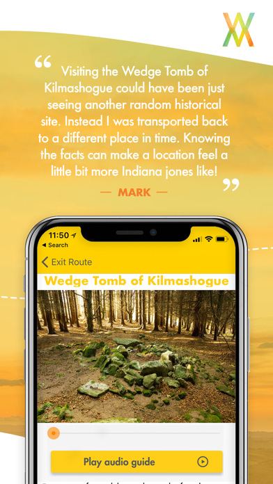
Waymarked Trails
Audio guide for hiking trails.
GratisOffers In-App Purchases
2.96for iPhone, iPad and more
Age Rating
Waymarked Trails Screenshots
About Waymarked Trails
AUDIO GUIDE
Keep your head in the spectacular scenery. The Waymarked Trails App delivers incredible all researched by actual local, writers, explorers and historians and brought to you through local voices.
OFFLINE MAPS - EVERYTHING WORKS OFFLINE
The entire app is built to work when you don't have any cell or mobile phone coverage. That not only saves you battery as the entire trail can hiked in an airplane mode without ever connecting to the web, and you still get all of the maps, audio, photos, accommodation without once connecting. Just simply download the trail, and then download the maps for offline use and you are ready to go.
MARKERS AT EVER KM
One of the most difficult things about long-distance hikes is when you don't have a sense of progress. Our app has a marker at every kilometer so you know how far you have gone and how far is left to go. Couple with that we have detailed elevation profiles so you know exactly what challenge is ahead.
ELA-LOCATION - ONLY ON WAYMARKED TRAILS
Our unique ela-location feature shows your location live on the elevation profile as you hike. So not only will you know where you are on the map, you will know how far you are far on the climb as well.
PHOTOS OF THE FULL TRAIL
We have travelled and photographed the entire trail ourselves so you can pick the places you want to see. There is nothing worse than hiking an extra few kilometres to a place that disappoints you. Use our images to find what compels you.
BEST ACCOMMODATION ON THE ROUTE
We have hand selected and stayed in lots of locations along the trail and then we handpick the best for you. See the blue map markers to check out the accommodation we have selected.
Show More
Was ist neu in der neuesten Version 2.96
Last updated on Oct 1, 2018
Alte Versionen
The Dublin Mountains Way is now live. We have updated our UI and have prepared the app for major upgrades in version 3.0 coming soon.
Show More
Version History
2.96
Oct 1, 2018
The Dublin Mountains Way is now live. We have updated our UI and have prepared the app for major upgrades in version 3.0 coming soon.
2.95
Sep 29, 2018
The Dublin Mountains Way is now live. We have updated our UI and have prepared the app for major upgrades in version 3.0 coming soon.
2.90
Sep 22, 2018
The Dublin Mountains Way has Arrived!! Now featuring in trails in Northern Ireland, Kery, Dingle, Dublin and Wicklow!
2.80
Sep 11, 2018
We update our app regularly for stability and user experience. This is one of those updates!
2.75
Aug 31, 2018
Minor bug repairs for a more stable app.
2.70
Aug 29, 2018
New faster more reliable system for downloading trails.
2.65
Aug 26, 2018
UI update to the Intro screen and a number of minor bug fixes.
2.60
Aug 18, 2018
New feature added that shows the users current location on the elevation chart in both the full map view and the individual stage view.
Fixed a bug where the app goes back to the main screen after completing a download.
2.50
Jul 23, 2018
Minor bug fix.
2.40
Jul 20, 2018
Fix to location based notifications.
2.35
Jul 17, 2018
Update fixing several major bugs.
2.15
Jul 15, 2018
Minor bug fix that prevented loading of Ways when offline.
2.1
Jul 9, 2018
Bug fixes and new features.
-Fixed bug that causes a crash when downloading trail.
-Other minor bugs fixed.
-Fixed bug that causes a crash when downloading trail.
-Other minor bugs fixed.
2.0
Jul 2, 2018
Version 2.0 of the Waymarked Trails App is here. Based on your feedback we have improved the app.
-Trail downloads now happen in a fraction of the time
-Simplified User Interface
-More screen space
-Major stability improvements.
-Trail downloads now happen in a fraction of the time
-Simplified User Interface
-More screen space
-Major stability improvements.
1.03
May 2, 2018
Minor UI improvements and adjustments to automatically add new ways to download as they become available.
1.02
Apr 5, 2018
Fixed crash when downloading a trail for the first time.
1.01
Mar 28, 2018
Bug fix for Traditional / Alternative menu picture not showing up.
1.0
Mar 27, 2018
Waymarked Trails FAQ
Klicken Sie hier, um zu erfahren, wie Sie Waymarked Trails in eingeschränkten Ländern oder Regionen herunterladen können.
Überprüfen Sie die folgende Liste, um die Mindestanforderungen von Waymarked Trails zu sehen.
iPhone
Erfordert iOS 11.0 oder neuer.
iPad
Erfordert iPadOS 11.0 oder neuer.
iPod touch
Erfordert iOS 11.0 oder neuer.
Waymarked Trails unterstützt Englisch
Waymarked Trails beinhaltet In-App-Käufe. Bitte überprüfen Sie den folgenden Preisplan:
The Wicklow Way
9,99 €
The Dingle Way
9,99 €
The Kerry Way
9,99 €
Dublin Mountains Way
3,99 €
West Highland Way
9,99 €
Tour du Mont Blanc
12,99 €
Causeway Coast Way
6,99 €
Kerry Camino
3,99 €