fleeteyes
Emergency Vehicle Tracking
Free
3.5.1for iPhone, iPad and more
Age Rating
fleeteyes Screenshots
About fleeteyes
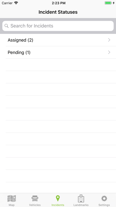
Exclusively for fleeteyes web service customers, the Fleeteyes Monitor app gives you access to dispatch that was only available if you were in the communications center or in a vehicle with an expensive mobile data computer (MDC). The app provides real-time incident data, vehicle status and mapping right in the palm of your hand. Fleeteyes works across all disciplines giving senior leadership a common operating picture (COP).
Features:
- Individual secure login
- Embedded map with routing
- Detailed view of vehicles
- Detailed view of incidents with filtering
- Satellite, hybrid, and traffic map
Features:
- Individual secure login
- Embedded map with routing
- Detailed view of vehicles
- Detailed view of incidents with filtering
- Satellite, hybrid, and traffic map
Show More
What's New in the Latest Version 3.5.1
Last updated on Apr 5, 2021
Old Versions
Minor Google Maps fix.
Show More
Version History
3.5.1
Apr 5, 2021
Minor Google Maps fix.
3.4.3
Jun 26, 2020
iOS 13 SDK support
3.4.2
Dec 18, 2017
Updated splash screen and app icon.
3.4.1
Apr 20, 2016
Google Maps update
3.4
Feb 4, 2016
- Can now view landmarks, posts, and facilities on the map or in a list.
- Vehicles, Incidents, and Landmarks will now cluster on the map allowing high-level visibility while zoomed out.
- Can now view responding and transport lines for mutual aid incidents
- Can now turn on or off vehicle labels that appear on the map.
- If the call type icon is updated on the administration side, the change is made across all devices on the next refresh.
• Improved display of pickup and dropoff information.
• For mutual aid incidents, the call type reads Not Provided instead of No Call Type.
• Vehicle description is now visible.
• Can now view weather markers and radar information on the map.
3.2.2
Jul 1, 2015
Bug fixes
3.2
Jun 22, 2015
Bug fixes and stability improvements.
3.1
Nov 3, 2014
iOS8 compatibility and miscellaneous bug fixes.
3.0.8
Jun 3, 2014
Fixed issue where some map icons were missing
3.0.7
Apr 14, 2014
Fixed some issues in iOS7
3.0.6
Nov 25, 2013
Updated for iOS7, added create timestamp on incident list
3.0.5
Jul 2, 2013
Fixed lag when opening app for first time
3.0.4
Jun 27, 2013
Fixed icon issue
3.0.3
Jun 24, 2013
Added missing Ambulance icons
3.0.2
Oct 22, 2012
- Stability improvements.
- Filtered vehicles should now show correctly on the first vehicles list.
- Updated for the 4inch retina display.
- Fixed a number of issues with table layout.
- Filtered vehicles should now show correctly on the first vehicles list.
- Updated for the 4inch retina display.
- Fixed a number of issues with table layout.
3.0.1
Sep 24, 2012
- Added a button to show the current user location on the map.
- Fixed a bug that was causing the settings screen to display incorrectly.
- Fixed a number of visual bugs.
- Fixed a bug that was causing the settings screen to display incorrectly.
- Fixed a number of visual bugs.
3.0
Sep 10, 2012
- Customizable Background refreshing.
- New UI Design.
- Custom Zoom Settings.
- Improved performance.
- Bug Fixes.
- New UI Design.
- Custom Zoom Settings.
- Improved performance.
- Bug Fixes.
2.2
Nov 17, 2011
Fixed some formatting issues on iPad where vehicles were not showing all of the detail text.
Fixed some issues with the popover button in portrait mode on iPad.
Other minor visual improvements and bug fixes.
Fixed some issues with the popover button in portrait mode on iPad.
Other minor visual improvements and bug fixes.
2.1
Oct 26, 2011
Fixes some compatibility issues with iOS 5.
Improved mapping performance.
The iPhone map now has all the same features as the iPad version.
Improved mapping performance.
The iPhone map now has all the same features as the iPad version.
2.0
Oct 24, 2011
fleeteyes FAQ
Click here to learn how to download fleeteyes in restricted country or region.
Check the following list to see the minimum requirements of fleeteyes.
iPhone
Requires iOS 9.0 or later.
iPad
Requires iPadOS 9.0 or later.
iPod touch
Requires iOS 9.0 or later.
fleeteyes supports English