Georgia State Roads

Georgia State Roads


Traffic Reports & Cameras


1,99 €Best Deal Ever
3.0for iPhone, iPad and more
2.7
9 Ratings
Coderun Technologies Ltd
Developer
4,8 Mo
Size
Jun 29, 2022
Update Date
#99
in Travel
4+
Age Rating
Age Rating
4+
Apps in this category do not contain restricted content.
9+
Apps in this category may contain mild or occasional cartoon, fantasy or real-life violence, as well as occasional or mild adult, sexually suggestive or horrifying content and may not be suitable for children under 9 years of age.
12+
Apps in this category may contain occasional mild indecent language, frequent or intense cartoon or real-life violence, minor or occasional adult or sexually suggestive material, and simulated gambling, and may be for children under 12 years of age.
17+
You must be at least 17 years old to access this App.
Apps in this category may contain frequent and intense offensive language; Frequent and intense cartoon, fantasy or realistic violence: frequent and intense adult, scary and sexually suggestive subjects: as well as sexual content, nudity, tobacco, alcohol and drugs, may not be suitable for children under 17 years of age.
Georgia State Roads Captures d'écran
Georgia State Roads AfficheGeorgia State Roads AfficheGeorgia State Roads AfficheGeorgia State Roads AfficheGeorgia State Roads Affiche

About Georgia State Roads

Live traffic reports and cameras for Georgia including Atlanta, Columbus, and Augusta. Save your favorite cameras for quick access. The Summer 2022 release includes dark mode and camera sharing.

KEY FEATURES:
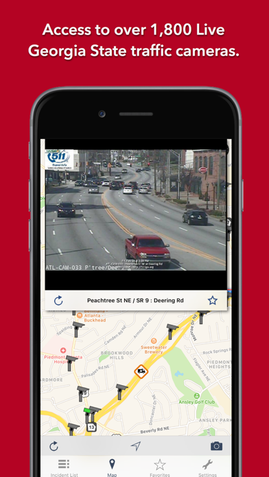
Live data from The Georgia Department of Transportation (GDOT):
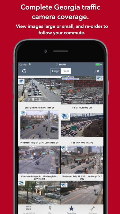
- 1,812 traffic cameras covering Georgia State.
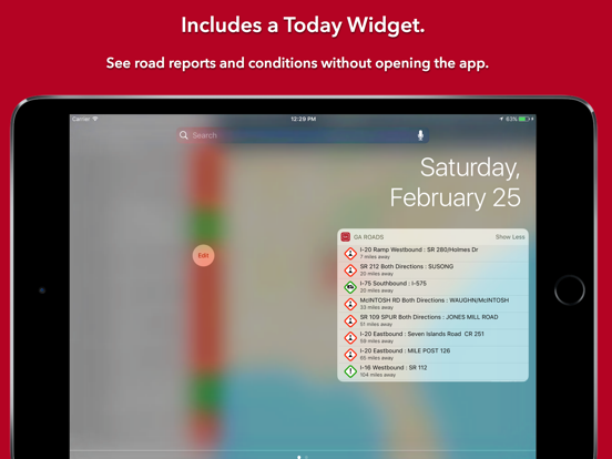
- Today screen widget to show at a glance the nearest current traffic incidents
- Optimised for all iPhone and iPad models; fully tested on iOS9, iOS10 and iOS11.
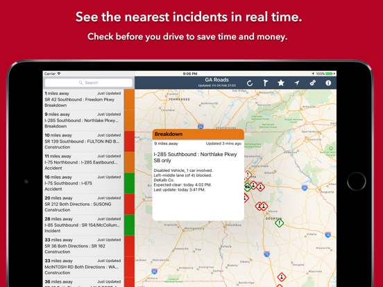
MAP VIEW
- Shows current incidents and traffic cams
- Each incident is color coded as well as being represented by an icon showing the incident type.
- Clicking on an incident displays more detail right there on the map.
- The map view can also show live traffic camera images.
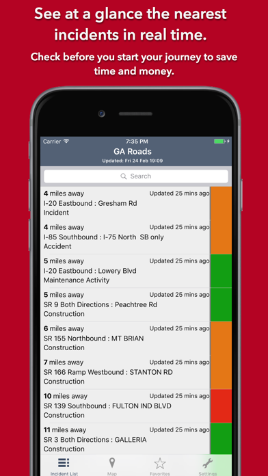
LIST VIEW
- Shows current incidents in order of distance from your current location (closest incidents are shown first).
- Each incident is color-coded to indicate the severity of the delay.
- You can quickly see the distance the incident is from you, the road name and the type of incident.
- The detail view shows the description together with a map showing the location.
- Full search functionality, works across both the list and map views.

TRAFFIC CAM FAVORITES
- Save your favorite cameras for quick access to see how clear/congested your usual routes are.

TODAY WIDGET
- Shows at a glance the nearest current traffic incidents without launching the app.

PERSONALISE
- Toggle traffic information on the map.
- Toggle auto refresh of camera images (will refresh every 10 seconds).
- Toggle always show map on app launch.
- Toggle construction on/off.
- You can configure which incidents are displayed according to the severity of the delay caused.
- Miles or KM setting.

CONTACT
- Email me for feature requests/bug reports etc. I would love to hear from you!

Data courtesy of The Georgia Department of Transportation (GDOT).
Show More

Quoi de neuf dans la dernière version 3.0

Last updated on Jun 29, 2022
Vieilles Versions
- Dark Mode throughout the app (iOS13+)
- Camera sharing: you can now easily share traffic camera images with your Twitter followers, Facebook friends or via email etc. Press the sharing button on the camera screen to get started.
- Increased the size of the Favorites screen on the iPad (based on user feedback).
- Fix for buttons not appearing on the map toolbar with the Bold Text Accessibility option enabled.
Show More
Version History
3.0
Jun 29, 2022
- Dark Mode throughout the app (iOS13+)
- Camera sharing: you can now easily share traffic camera images with your Twitter followers, Facebook friends or via email etc. Press the sharing button on the camera screen to get started.
- Increased the size of the Favorites screen on the iPad (based on user feedback).
- Fix for buttons not appearing on the map toolbar with the Bold Text Accessibility option enabled.
2.0
Feb 6, 2018
This app has been updated by Apple to display the Apple Watch app icon.

-Updated for iOS11 and the new iPhone X (looks and works brilliantly on the iPhone X!!).
-Option to use miles or kilometres.
-New iPad toolbar.
-Various performance improvements and fixes.
1.0
Feb 28, 2017

Georgia State Roads Prix

Aujourd'hui:
1,99 €
Le plus bas:
1,99 €
Le plus élevé:
2,49 €

Georgia State Roads FAQ

Cliquez ici pour savoir comment télécharger Georgia State Roads dans un pays ou une région restreints.
Consultez la liste suivante pour voir les exigences minimales de Georgia State Roads.
iPhone
Nécessite iOS 12.0 ou version ultérieure.
iPad
Nécessite iPadOS 12.0 ou version ultérieure.
iPod touch
Nécessite iOS 12.0 ou version ultérieure.
Georgia State Roads prend en charge Anglais

Alternative à Georgia State Roads

Tu pourrais aussi aimer

Obtenir plus de Coderun Technologies Ltd