Santa Fe County Trail Maps
Gratuit
2.02for iPhone, iPod touch
Age Rating
Santa Fe County Trail Maps Captures d'écran
About Santa Fe County Trail Maps
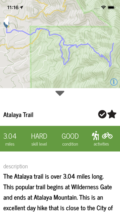
This app is designed to highlight the hiking, biking, mountain biking, backpacking, and horseback riding trails in Santa Fe County. Trail information is accompanied with maps, elevation profiles, as well as other pertinent information regarding trail type, activities, length, and more.
Show More
Quoi de neuf dans la dernière version 2.02
Last updated on May 21, 2019
Vieilles Versions
The version has an updated Trail Overview screen with color-coded difficulty levels. It also exposes more trailheads for each trail system.
Show More
Version History
2.02
May 21, 2019
The version has an updated Trail Overview screen with color-coded difficulty levels. It also exposes more trailheads for each trail system.
2.01
Feb 14, 2019
- Bug fixes
2
Feb 8, 2019
This version has an updated user experience with additional information for each trail in Santa Fe County. The version includes an overview map with trailhead markers, and the ability to mark trails as favorite or complete, and filtering. Also included are elevation profiles and notice text for trail closures, or information pertinent to a trail.
1.1.1
May 19, 2017
Location permission warning.
0.9.2
Apr 25, 2017
Connection error has been resolved.
1.0
Aug 6, 2016
Santa Fe County Trail Maps FAQ
Cliquez ici pour savoir comment télécharger Santa Fe County Trail Maps dans un pays ou une région restreints.
Consultez la liste suivante pour voir les exigences minimales de Santa Fe County Trail Maps.
iPhone
Nécessite iOS 9.0 ou version ultérieure.
iPod touch
Nécessite iOS 9.0 ou version ultérieure.
Santa Fe County Trail Maps prend en charge Anglais