White Mtn Hiker Pemi

White Mtn Hiker Pemi


Offline hiking NH White Mtns


Gratuit

2.0.0for iPhone, iPad and more
9.9
2 Ratings
Richard Allmendinger
Developer
325,1 Mo
Size
Apr 3, 2023
Update Date
Sports
Category
4+
Age Rating
Age Rating
4+
Apps in this category do not contain restricted content.
9+
Apps in this category may contain mild or occasional cartoon, fantasy or real-life violence, as well as occasional or mild adult, sexually suggestive or horrifying content and may not be suitable for children under 9 years of age.
12+
Apps in this category may contain occasional mild indecent language, frequent or intense cartoon or real-life violence, minor or occasional adult or sexually suggestive material, and simulated gambling, and may be for children under 12 years of age.
17+
You must be at least 17 years old to access this App.
Apps in this category may contain frequent and intense offensive language; Frequent and intense cartoon, fantasy or realistic violence: frequent and intense adult, scary and sexually suggestive subjects: as well as sexual content, nudity, tobacco, alcohol and drugs, may not be suitable for children under 17 years of age.
White Mtn Hiker Pemi Captures d'écran
White Mtn Hiker Pemi AfficheWhite Mtn Hiker Pemi AfficheWhite Mtn Hiker Pemi AfficheWhite Mtn Hiker Pemi AfficheWhite Mtn Hiker Pemi AfficheWhite Mtn Hiker Pemi AfficheWhite Mtn Hiker Pemi AfficheWhite Mtn Hiker Pemi Affiche

About White Mtn Hiker Pemi

The White Mountain Hiker (WMH) apps are the ones I wrote for my own hiking. The apps to prioritize 2 things of interest to serious hikers: offline access to data about their hike and privacy. WMH Pemi spans from Franconia Notch to Crawford Notch and from the north end of the Pemigewasset Wilderness to the northern tip of the NH Lakes Region. The apps come with:

• Two different base maps, each with 40 ft contours and a maximum resolution of 2 meters per pixel (zoom level 16). A simple gray shaded relief map that emphasizes topography whereas a full color base map emphasizes ledges, gullies, etc.

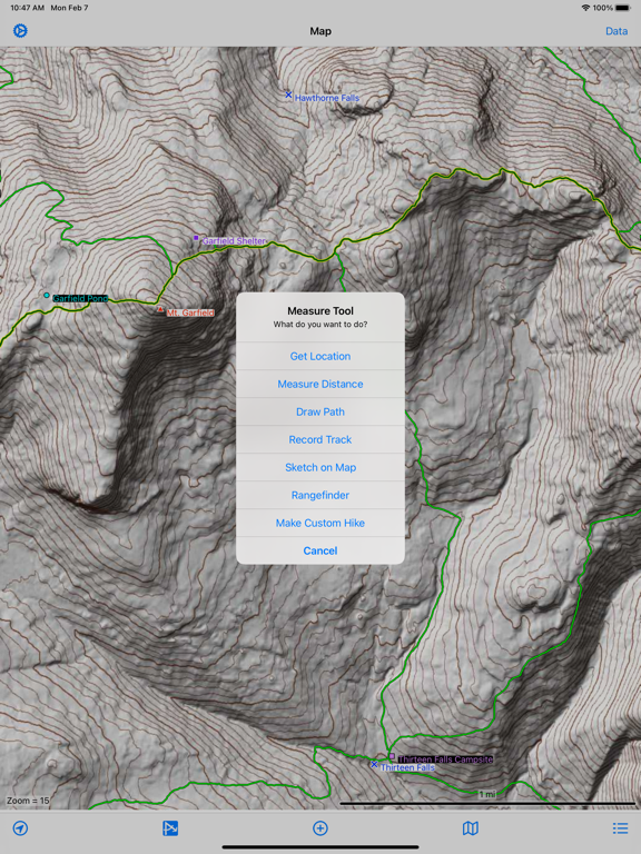
• A 10 m resolution, on-board digital elevation model (DEM) which enables the user to get the elevation at any point, draw topographic profiles along any path, calculate true slope distance and not just map distance. No internet connection needed for topo or maps.

• Digitized trails for the entire region from the U.S. Forest Service (with 5 m point spacing) and NH Granit public databases. Toggle on or off different types, make calculations, plot topo profiles along the trails, change the colors of different trail types to suite your liking.

• A builtin database of many hundreds of geographic points, summits, huts and shelters, natural features of interest, and other points of interest (POIs). All major summits have been located using the highest elevation in the DEM.

• Custom hikes can combine segments of several different existing trails and you still get all the data on slope, elevation gain, etc. that you could want.

• Record GPS tracks, or freehand draw paths to record your favorite bushwhack. Topo profiles can be plotted along these paths so you can see what you are getting yourself into (or already did). Share these off-trail excursions as .GPX files with other users.

• An innovative rangefinder uses the builtin DEM along with the device compass and accelerometers to give you the distance and bearing to a feature simple by pointing the device camera at it. The accuracy of this feature is subject to the accuracy of the device magnetometer, which is easily affected by magnetic fields.

• Set your own POIs and attach photos to them or take new photos without leaving the app. Photos can be annotated. User POIs can be emailed to anyone the user likes. Do not rely on this as a safety feature as it only works when you have a cellular data connection and there are many parts of the White Mountains without reliable cell service!

• Weather forecasts from the National Weather Service (NWS) — with hourly conditions for the next seven days — for any POI. Want to see how hard the wind is blowing on top of Mt. Washington? Sure! This feature requires an internet connection.

• Weather radar base and composite reflectivity from the NWS can be overlaid right on the base map so you can see where inclement weather lies with respect to your hike. This feature requires an internet connection but your location is not sent to the NWS server.

• A builtin Apple Maps screen displays all of the trails and POIs on a satellite, hybrid, or road map.

• Your privacy is respected: your location is never sent to any advertising agency, the programmer, or anyone else (unless you choose the email or message your location). The app is not ad-supported, does not collect any personal data, and can be used without ever connecting to the internet (except for the weather functions).

• Some things that the app does NOT have: (a) builtin trail descriptions (although you can tap a button in the trail details screen to launch your device browser to search the internet for information about the trail). (b) Social networking. You cannot connect or post to your favorite social networking sites from within the app. There are plenty of fine apps that will let you do this (and harvest your location at the same time!). (c) Automatic calculation of your ETA at a POI, the end of the trail, etc.
Show More

Quoi de neuf dans la dernière version 2.0.0

Last updated on Apr 3, 2023
Vieilles Versions
V. 2.0 -- 31 March 2023

• New color base map is somewhat less garnish green and is lighter overall giving better visibility of the overlying trails and points of interest.

• The online satellite map view is more functional now showing exactly the same information as the base maps. You can measure distances, draw paths, sketch on the image, etc. Be aware, however, that the online map usage will download imagery over your cellular data connection when outside of wireless range and you may incur download charges.

• Bug fixes and interface tweaks.
Show More
Version History
2.0.0
Apr 3, 2023
V. 2.0 -- 31 March 2023

• New color base map is somewhat less garnish green and is lighter overall giving better visibility of the overlying trails and points of interest.

• The online satellite map view is more functional now showing exactly the same information as the base maps. You can measure distances, draw paths, sketch on the image, etc. Be aware, however, that the online map usage will download imagery over your cellular data connection when outside of wireless range and you may incur download charges.

• Bug fixes and interface tweaks.
1.0.5
Mar 17, 2022
v. 1.0.5 -- 2022-03-16

• The weather graph on the Weather screen now displays the wind direction as small arrows. This can be toggled on or off by tapping the wind direction row in the table of conditions below the plot.

• Tapping the map selector at the top of the Legend Screen will select the new map and automatically close the Legend Screen now. You will no longer have to swipe downwards to dismiss the Legend screen manually.

• Subtle improvements to the base maps which include display of more ponds and lakes.

• Fixed a daylight saving time bug that affected the sunrise and sunset times in the Weather Screen.
1.0.1
Feb 8, 2022

White Mtn Hiker Pemi FAQ

Cliquez ici pour savoir comment télécharger White Mtn Hiker Pemi dans un pays ou une région restreints.
Consultez la liste suivante pour voir les exigences minimales de White Mtn Hiker Pemi.
iPhone
Nécessite iOS 11.0 ou version ultérieure.
iPad
Nécessite iPadOS 11.0 ou version ultérieure.
iPod touch
Nécessite iOS 11.0 ou version ultérieure.
White Mtn Hiker Pemi prend en charge Anglais

Alternative à White Mtn Hiker Pemi

Tu pourrais aussi aimer

Obtenir plus de Richard Allmendinger