AvyPal is an avalanche awareness safety app for the iPhone.
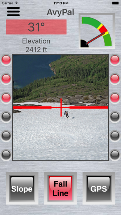
The AvyPal phone app can assist backcountry travelers in identifying potential avalanche terrain. AvyPal is a simple "see through" app that uses the phone's camera view to let you view the terrain you are approaching. Three different modes are available to fit the backcountry situations you often encounter:
Fall Line Mode - Shows the angle and avalanche risk of a slope you intend to descend, or ascend.
Slope Mode - Shows the angle and avalanche risk of a slope you intend to cross.
GPS Mode - Uses GPS data to audibly alert you if you are descending or ascending a slope angle that is associated with avalanche risk. Audible alerts are given every 5 seconds if in avalanche terrain. A graph is also shown in the mode so you can review if you have recently travelled in dangerous terrain.
AvyPal uses color-coded indicators to indicate the avalanche risk of backcountry terrain. Red indicates a high probability avalanche slope (30-45 degrees). Yellow indicates a lower probability avalanche slope (25-30 degrees or 45-50 degrees). Green indicates slopes of less likely avalanche potential (less than 25 degrees or greater than 50 degrees).
AvyPal is a backcountry tool for help in making route choice decisions. AvyPal does not replace professional avalanche safety training, experience or good judgement. Get avalanche awareness and safety training before traveling in the backcountry.
Have fun in the backcountry. And if you have a question about the safety of the snow slope ahead ... don't hesitate to ask your AvyPal for advice!