Early Spring 2024
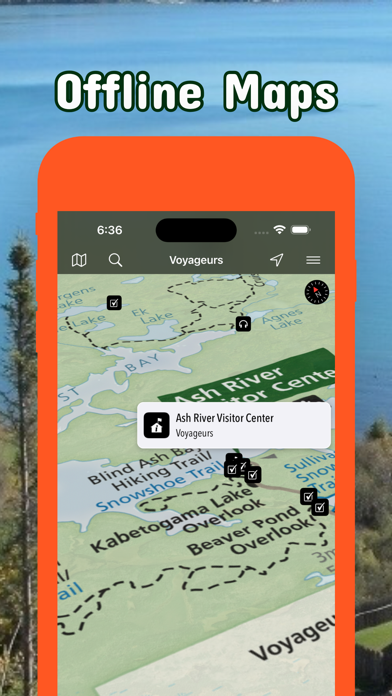
Updates: Mississippi National River & Recreation Area, Voyageurs National Park
Updates: Contains the latest data by the National Park Service (NPS), Bureau of Land Management (BLM), United States Forest Service (USFS) and recreation.gov.
Winter 2023/2024
Updates: Upper Sioux Agency, North Country National Scenic Trail
Updates: Contains the latest data by the National Park Service (NPS), Bureau of Land Management (BLM), United States Forest Service (USFS) and recreation.gov.
Early Winter 2023/2024
Updates: Grand Portage
Updates: Contains the latest data by the National Park Service (NPS), Bureau of Land Management (BLM), United States Forest Service (USFS) and recreation.gov.
Fall 2023
Updates: Superior National Forest
Updates: Contains the latest data by the National Park Service (NPS), Bureau of Land Management (BLM), United States Forest Service (USFS) and recreation.gov.
Summer 2023
Updates: Contains the latest data by the National Park Service (NPS), Bureau of Land Management (BLM), United States Forest Service (USFS) and recreation.gov.
Summer 2023
New: Watch some interesting videos and audios, produced by the National Park Service.
Updates: Contains the latest data by the National Park Service (NPS), Bureau of Land Management (BLM), United States Forest Service (USFS) and recreation.gov.
Late Spring 2023
New: We remastered all maps for higher quality and optimized data usage.
Updates: Contains the latest data by the National Park Service (NPS), Bureau of Land Management (BLM), United States Forest Service (USFS) and recreation.gov.
Spring 2023
Updates: Agassiz, Alborn-Pengilly, Alger-Grade, Finland, Alvwood-Squaw Lake, Appleton, Axtell Riding Area, Balsam, Bemis Hill, Blind Lake, Chatfield, Grand Portage, Pat Bayle, Wealthwood and Solana.
Updates: Contains the latest data by the National Park Service (NPS), Bureau of Land Management (BLM), United States Forest Service (USFS) and recreation.gov.
Early Spring 2023
Updates: Contains the latest data by the National Park Service (NPS), Bureau of Land Management (BLM), United States Forest Service (USFS) and recreation.gov.
Winter 2022/23
New: Earth isn't flat anymore! Check out the new globe view when you zoom way out.
Updates: Minnesota snowmobile trails
Updates: Contains the latest data by the National Park Service (NPS), Bureau of Land Management (BLM), United States Forest Service (USFS) and recreation.gov.
Early Winter 2022
New: Current weather data and 10-day forecast powered by Apple Weather
New: Hyperlocal weather data for every Point of Interest (POI).
Updates: Contains the latest data by the National Park Service (NPS), Bureau of Land Management (BLM), United States Forest Service (USFS) and recreation.gov.
Fall 2022
Updates: Contains the latest data by the National Park Service (NPS), Bureau of Land Management (BLM), United States Forest Service (USFS) and recreation.gov.
Late Summer 2022
New: Redesigned for iPad!
Updates: Bear Head Lake, Forestville/Mystery Cave, George H. Crosby Manitou, Zippel Bay
Updates: Contains the latest data by the National Park Service (NPS), Bureau of Land Management (BLM), United States Forest Service (USFS) and recreation.gov.
Summer 2022
Updates: Use the new POI search feature and find more than 50.000 campgrounds, trailheads, lakes and other points of interest.
Updates: Contains the latest data by the National Park Service (NPS), Bureau of Land Management (BLM), United States Forest Service (USFS) and recreation.gov.
- Applied insect repellent to recently discovered bugs on iPads near you.
- No actual insects were harmed in the making of this latest production.
Early Summer 2022
New: Use the new search feature and find trail heads, campgrounds and all other points of interest in no time.
Updates: Contains the latest data by the National Park Service (NPS), Bureau of Land Management (BLM), United States Forest Service (USFS) and recreation.gov.
Spring 2022
New: North Country Trail maps
Updates: Cascade River, Judge C.R. Magney
Spring 2022
Updates: improved 3D maps
Updates: Big Bog, Minnesota Valley, Wild River
Winter 2021/2022
New: Maps in 3D!
Updates: Big Fork, Blue Earth, Cannon, Cedar, Cloquet, Crow Wing, Des Moines, Kettle, Little Fork, Long Prairie, Lake Superior, Minnesota, Mississippi, North Fork Crow, Otter Tail, Pine, Redwood, Red Lake, Red, Root, Rum, Sauk, Shell Rock, St. Louis, Vermilion, Zumbro
Winter 2021
Updates for iOS 15 and iPad
Updates: Lake Superior, Mille Lacs Kathio, Minnesota River, Mississippi River, Saint Croix, Savanna Portage