Nature Notes

Nature Notes


Record everything on your hike


無料Offers In-App Purchases

5.33for iPhone, iPad and more
Kenneth Wahl
Developer
171.3MB
Size
2024年04月07日
Update Date
Education
Category
4+
Age Rating
Age Rating
4+
Apps in this category do not contain restricted content.
9+
Apps in this category may contain mild or occasional cartoon, fantasy or real-life violence, as well as occasional or mild adult, sexually suggestive or horrifying content and may not be suitable for children under 9 years of age.
12+
Apps in this category may contain occasional mild indecent language, frequent or intense cartoon or real-life violence, minor or occasional adult or sexually suggestive material, and simulated gambling, and may be for children under 12 years of age.
17+
You must be at least 17 years old to access this App.
Apps in this category may contain frequent and intense offensive language; Frequent and intense cartoon, fantasy or realistic violence: frequent and intense adult, scary and sexually suggestive subjects: as well as sexual content, nudity, tobacco, alcohol and drugs, may not be suitable for children under 17 years of age.
Nature Notes スクリーンショット
Nature Notes ポスターNature Notes ポスターNature Notes ポスターNature Notes ポスターNature Notes ポスターNature Notes ポスターNature Notes ポスターNature Notes ポスター

About Nature Notes

NatureNotes allows you to record and share notes, photos, and audio recordings on any walk, tour, hike, or just a stroll around your neighborhood. If you are a serious photographer, advanced tools allow you to load pictures from another camera into the walk record. There are several options for sharing walks with friends or other NatureNotes users, including email, Web page creation, or sending a NatureNotes file to another user.
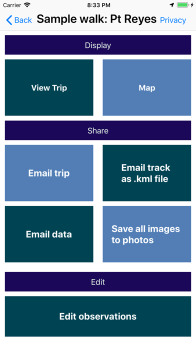
Easy sharing:

Take photos, save notes, and record audio on your Apple iPhone or iPad. The app offers powerful editing features to create a slideshow or Web folder that you can email to your friends or upload to a server.


Interactive maps:

Apple maps embedded in NatureNotes shows where you are at all times, as well as where you've been on your hike. Satellite view can show you the terrain with a data connection. If you repeat a hike you've taken before, you can use the interactive map to see where you are relative to your last hike.


Organization:

Divide your trip into multiple hikes, then put them under a single header. Use powerful header features to combine the subsumed hikes into a single slideshow, email, or web folder for sharing.

Creating multiple databases offers a system for organizing larger groups of walk records. Records can be copied directly to other databases for easy sorting and reorganization.


Photo merging:

Take photos with another camera and merge them directly into your NatureNotes recordings. A smart system using dates and timestamps places photos into their correct positions within previously-recorded records.

Even without a recorded hike, create a new record from a set of location-encoded photographs, and see exactly where you took the photos, using the embedded Apple Maps features. If the photos contain captions from another photo-editing program, the captions will be copied into NatureNotes titles for immediate labelling within NatureNotes. All slideshow features and email or Web sharing features can then be used with the new records.

Create a kml file for viewing the track in another tracking application, or a gpx file for loading a track with GPS data into photo editing applications.


GPS tracking:

NatureNotes provides detailed tracking data for your walks, regardless of whether you are in cellular range or not. Tracks can be exported as KML or GPX files for use in other applications.

Duplication and backups:

Take a complete set of records and copy them to another device, with a cable and computer, regardless of record sizes. In this way complete records can be shared or backed-up without loss of information or photographic resolution.
Show More

最新バージョン 5.33 の更新情報

Last updated on 2024年04月07日
旧バージョン
Minor bug fixes.
Show More
Version History
5.33
2024年04月07日
Minor bug fixes.
5.32
2024年02月23日
The add button in a header record accessed the incorrect function. It now correctly prompts to add a new walk or header record.
5.31
2024年02月11日
Fixed the image and audio edit screens that are accessible while running a slideshow so that all fields are available for editing.
5.3
2024年02月02日
Added an Agenda Management function that allows pre-loading of walk records based on a planned agenda. Numerous interface and efficiency improvements.
5.2
2023年07月17日
Fixed an issue that caused a crash if an image folder was imported into an empty database.
Fixed an issue that caused a crash if an image had a caption or name shorter than four characters.
5.1
2023年06月21日
The bird list was upgraded to version 13.1 (2023). Several interface improvements and bug fixes. If menus are open on a walk page, the menus now remain visible and operational when the device is rotated. The bird-relevant setting now works properly: The bird list and additional info buttons are hidden when this feature is turned off.
5.0
2023年05月21日
Redesigned exported Web page with an optional interactive map showing the recorded track and locations of observations and images. PNG images can now be imported. Audio is now exported as MPEG for better compatibility with Web browsers. Various interface improvements and upgrades.
4.32
2023年04月04日
Accessing the new photo import routine no longer freezes the app when backing up to a prior screen. Photos imported manually into new walk records are now working correctly. Other minor bug fixes.
4.31
2023年03月31日
The new photo import routine now places the records in a correct chronological order. The number of imported images per walk record is now reported correctly. Image sequence counters were broken in the last version; this has been fixed.
4.3
2023年03月26日
Slideshow operation has been improved. Importing photos from another camera into existing walk records has been rewritten. Additional bug fixes and stability improvements.
4.2
2023年02月22日
Saving an edited field with prior values could cause instability and possibly a crash; this has been fised. Minor bug fixes.
4.1
2023年01月07日
Map-generating algorithms were rewritten for increased efficiency and consistency.
Several bug fixes and interface improvements.
4.0
2022年10月12日
The camera interface now uses the Apple designed camera, which provides standard controls for wide angle and zoom lenses. Minor bug fixes and interface improvements.
3.95
2022年09月25日
Fixes an issue that prevented the image display submenu from working correctly.
3.94
2022年07月17日
GPS coordinates are now saved with greater precision. Adjusted saving/cancelling operations for all screens with text views so that warnings are now posted if the user tries to cancel without having saved. The cancel and save menu items are also synchronized with whether the fields have changed from their original values either after entering the window or after the latest save. The fixGps screen has been improved so that new GPS coordinates can be more easily entered. Pressing the GPS coordinate field now copies the latitude & longitude to the clipboard. Miscellaneous interface improvements.
3.93
2022年03月18日
Displaying a map now uses coordinates taken every minute instead of more frequent intervals to reduce computation
time.
Cancel buttons were added to functions that could take a significant period of time.
Set the creation date of exported files to match the original creation date of the corresponding records.
Added options to split or combine entire walk records.
Miscellaneous bug fixes.
The summary map function has been fixed. Interactive mapes were still available, but a static image containing the path and any annotations was not generated.
The sample walk record had become corrupted. This has been fixed.
Miscellaneous bug fixes and interface improvements.
3.92
2021年12月22日
Copying, importing, and duplicating records, as well as producing web pages, could result in errors if text fields contained apostrophes. This has been fixed.
An issue with producing web pages from slideshow-only that could result in unacceptably long image processing times has been fixed.
3.91
2021年10月06日
Various bug fixes and interface improvements. Both title and caption are now read while importing photos. Camera orientation starts with the back camera; its position is then retained unless it's manually changed. Imporing photos and audio files now uses GPS timestamps instead of observation record timestamps, as GPS data represent more accurately the full duration of the walk. An imported photo or audio can now be moved to either a different walk record or a new record, from its initial assignment.
3.9
2021年08月25日
A database issue preventing some upgrades has been fixed. Minor formatting improvements.
3.8
2021年08月11日
GPX files exported from a track now contain times formatted as UTC strings, for better compatibility with other applications.
3.7
2021年07月18日
Processing emails and web pages will no longer crash if GPS data are requested and an image does not
contain GPS data.
Web page processing has been improved by processing titles and subtitles under an image as text,
instead of incorporating them into the image itself (the latter is the default method for email presentation).
Importing a walk now moves the new walk to the top of the walk list, instead of the position immediately
prior to the first header record.
3.6
2021年07月14日
A problem with database processing blocked GPS data from being copied if walks were duplicated. This has been fixed.
Added an option to move all records from one walk record to another walk record with the same timestamp.
3.5
2021年07月11日
Creating a summary map from a header record with no annotations was not working; this has been fixed.
Creating a walk map from an observation list now applies a title to the new record.
3.4
2021年07月01日
A .gpx track file can now be produced under Track Options.
3.3
2021年06月27日
Tracks were not being displayed correctly due to an adjustment in processing of track data. This has been fixed.
A new track editing screen has been added to a renamed "Track options" button. The editing screen can be used to remove GPS points that have errors or go beyond the limits of the actual walk record.

Nature Notes FAQ

ここをクリック!地理的に制限されているアプリのダウンロード方法をご参考ください。
次のリストをチェックして、Nature Notesの最低システム要件をご確認ください。
iPhone
iOS 15.5以降が必要です。
iPad
iPadOS 15.5以降が必要です。
iPod touch
iOS 15.5以降が必要です。
Nature Notesは次の言語がサポートされています。 英語
Nature Notes二は内課金があります。課金要素と価格をご覧ください。
English
¥700

Nature Notesの類似アプリ

あなたも好きかも

Kenneth Wahl からもっと手に入れる