Topographic Maps & Trails
USGS Topo Map & Hiking Trails
$4.99
1.4for iPhone, iPad and more
Age Rating
Topographic Maps & Trails スクリーンショット
About Topographic Maps & Trails
The #1 Topo Maps App for iOS
MAIN FEATURES INCLUDE:
- USGS Topographic Maps
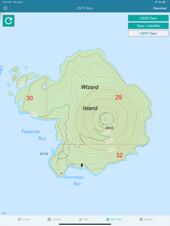
- USFS Topographic Maps
- Satellite + Topo Maps
- Hiking Tracker
* Download all maps for offline use
USGS TOPO MAP
USGS Topo is a tile cache base map service that combines the most current data in The National Map (TNM), and other public-domain data, into a multi-scale topographic reference map.
TOPO + SATELLITE
USGS Imagery Topo is a tile cache base map of orthoimagery in The National Map and US Topo vector data. Orthoimagery data are typically high resolution images that combine the visual attributes of an aerial photograph with the spatial accuracy and reliability of a planimetric map.
Data themes included are Boundaries, Geographic Names, Transportation, Contours, Hydrography, Land Cover, Shaded Relief, Trails, etc.
USFS TOPO MAP
The USFS Topo Map Area of Interest covers the USFS National Forests and Grasslands.
HIKING TRACKER
Now you can track all of your hiking stats!
- Track total distance, vertical, time
- Track calories burned
- Keep track of yearly stats
- Color coded tracks by elevation
- Backup your hike data to iCloud
- iOS 14 home screen widget
Have questions?
Feel free to contact me at support@lwbrandsllc.com
Show More
最新バージョン 1.4 の更新情報
Last updated on 2024年02月01日
旧バージョン
+ Fixed a few bugs
Thank you for the positive feedback!
Thank you for the positive feedback!
Show More
Version History
1.4
2024年02月01日
+ Fixed a few bugs
Thank you for the positive feedback!
Thank you for the positive feedback!
1.3
2024年01月04日
+ Fixed a few bugs
Thank you for the positive feedback!
Thank you for the positive feedback!
1.2.11
2022年12月04日
+ Updated Hiking Stats Home Screen Widget
+ Fixed a few bugs
Thank you for the positive feedback!
+ Fixed a few bugs
Thank you for the positive feedback!
1.2.10
2021年12月22日
+ Updated Hiking Stats Home Screen Widget
+ Fixed a few bugs
Thank you for the positive feedback!
+ Fixed a few bugs
Thank you for the positive feedback!
1.2.9
2021年11月07日
+ Updated Hiking Stats Home Screen Widget
+ Fixed a few minor bugs
Thank you for the positive feedback!
+ Fixed a few minor bugs
Thank you for the positive feedback!
1.2.8
2021年09月11日
+ Updated Hiking Stats Home Screen Widget
+ Fixed a few minor bugs
Thank you for the positive feedback!
+ Fixed a few minor bugs
Thank you for the positive feedback!
1.2.7
2021年06月15日
+ Updated iOS 14 Hiking Stats Home Screen Widget
+ Fixed a few minor bugs
Thank you for the positive feedback!
+ Fixed a few minor bugs
Thank you for the positive feedback!
1.2.6
2021年02月21日
+ iOS 14 Hiking Stats Home Screen Widget
+ Fixed a few minor bugs
Thank you for the positive feedback!
+ Fixed a few minor bugs
Thank you for the positive feedback!
1.2.5
2020年10月11日
+ iOS 14 Hiking Stats Home Screen Widget
Thank you for the positive feedback!
Thank you for the positive feedback!
1.2.4
2020年04月14日
+ Improved the hiking tracker algorithm (distance accuracy)
Thank you for the positive feedback!
Thank you for the positive feedback!
1.2.0
2020年04月01日
+ Fixed a bug with the new hike tracking algorithm related to distance accuracy.
Thank you for the positive feedback!
Thank you for the positive feedback!
1.1.8
2020年03月31日
+ Improved hike tracking algorithm accuracy
Thank you for the positive feedback!
Thank you for the positive feedback!
1.1.5
2019年12月07日
+ Fixed the bug related to random crash issues with iOS 13
Thank you for the positive feedback!
Thank you for the positive feedback!
1.1.2
2019年08月08日
+ Download all maps for offline use!
+ New hiking tracker features
Thank you for the positive feedback!
+ New hiking tracker features
Thank you for the positive feedback!
1.0.6
2018年11月07日
+ Added US Forest Service Topo Maps
Previous Update:
+ Significantly improved map download speeds.
+ Added USGS Satellite+Topo Maps
Previous Update:
+ Significantly improved map download speeds.
+ Added USGS Satellite+Topo Maps
1.0.5
2018年11月06日
Significantly improved map download speeds.
1.0.3
2018年11月03日
New Topo + Satellite Map
1.0.1
2018年11月02日
Topographic Maps & Trails FAQ
Topographic Maps & Trailsは、以下の国または地域では利用できません。
Australia,Belize,Latvia,Turks and Caicos,Uzbekistan,Vanuatu,Switzerland,Czech Republic,Georgia,Guyana,Mauritius,Seychelles,Argentina,United Kingdom,Jamaica,Lao Peoples Democratic Republic,Montenegro,Antigua And Barbuda,Angola,Belgium,Bulgaria,Bhutan,Belarus,Sri Lanka,Nauru,Sierra Leone,Suriname,Swaziland,Bosnia & Herzegovina,Luxembourg,Maldives,Oman,Romania,Saudi Arabia,Slovakia,Sao Tome & Principe,Burkina Faso,Denmark,Libya,Uruguay,Vietnam,India,Malta,New Zealand,Russia,Taiwan,Bermuda,Iceland,Montserrat,Sweden,Hong Kong,Trinidad and Tobago,Mozambique,Zimbabwe,Chile,Cyprus,Japan,Lithuania,Colombia,Grenada,Iraq,Jordan,Cambodia,Portugal,United Arab Emirates,Germany,Fiji,Greece,Kyrgyzstan,Slovenia,Turkey,Brunei Darussalam,Bahamas,Kenya,Madagascar,Tonga,Bahrain,Egypt,Gabon,Indonesia,Cayman Islands,Kazakhstan,Palau,Albania,Mongolia,Paraguay,Bolivia,Hungary,Lebanon,Solomon Islands,Azerbaijan,Ecuador,Norway,Tunisia,Ukraine,Malawi,Singapore,Thailand,St. Vincent & The Grenadines,Cote Divoire,Cape Verde,Algeria,Estonia,Israel,South Korea,Niger,Philippines,Botswana,Finland,Peru,Pakistan,Venezuela,British Virgin Islands,Afghanistan,Austria,Benin,Turkmenistan,Barbados,Spain,France,Ghana,Ireland,Senegal,Chad,Netherlands,Rwanda,Brazil,China,Dominica,Gambia,Papua New Guinea,Serbia,Kosovo,Armenia,Dominican Republic,Liberia,Morocco,Malaysia,Cameroon,St. Lucia,Nigeria,Tajikistan,Uganda,Yemen,Anguilla,Moldova,South Africa,Congo,Guatemala,Mexico,Namibia,Nicaragua,Panama,Tanzania,Croatia,Italy,Macedonia,Mali,Myanmar,Poland,Zambia,Guinea-bissau,Honduras,Mauritania,Nepal,Qatar,El Salvador,Congo, Democratic Republic,Costa Rica,Micronesia,St. Kitts and Nevis,Kuwait,Macao
Topographic Maps & Trailsは次の言語がサポートされています。 English, French, Portuguese
ここをクリック!地理的に制限されているアプリのダウンロード方法をご参考ください。
次のリストをチェックして、Topographic Maps & Trailsの最低システム要件をご確認ください。
iPhone
Requires iOS 15.0 or later.
iPad
Requires iPadOS 15.0 or later.
Apple Watch
Requires watchOS 8.0 or later.
iPod touch
Requires iOS 15.0 or later.


