i-Hunting : GPS Maps App
Hunt Topo/Property Line Parcel
무료Offers In-App Purchases
105.0.0for iPhone, iPad and more
Age Rating
i-Hunting : GPS Maps App 스크린 샷
About i-Hunting : GPS Maps App
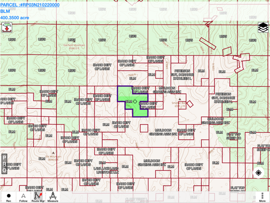
This hunting GPS app provides access to property line maps, parcels & public
lands, land ownership details. Map layers for 50+ states include hunting
zones, restricted areas, possible access areas, state refgues and more.
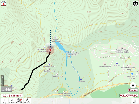
Vector topo maps with most accurate USGS elevation contours, hiking & biking
trails. Coverage includes all US states.
► Vector Topo Maps
√ Beautiful & detailed Hardware/GPU accelerated vector maps (text stays upright on rotation)
√ Vector USGS contours (Change height to ft or meter).
√ Covers popular hiking & biking trails and paths
► Parcel Maps
√ Includes following ownerhsip attributes (where available)
* Owner name and Owner address
* Site Address
* Parcel ID Total Value
► Hunt Planning maps
√ Possible Public Access
√ Public lands and Parcels
√ Hunting Zones
√ Game Distribution
√ Restricted Ares
√ Portions
► Offline vector maps
√ Easy to download offline topos
► PLSS maps
√ PLSS Townships and Sections (US Wide coverage)
► Custom base maps
√ Switch base maps between vector topos, hybrid satellite imagery and more
►GPS FEATURES
√ Record Tracks
√ Enter or import Waypoints.
√ Auto Follow
* Real Time Track Overlay
* Predicted Path Vector
* Course Up(Text stays upright)
* Speed & Heading
√ Route Assistance With Voice Prompts
* Prompts when approaching a boating route marker
* Continous distance & ETA updates
* Alerts when off route
* Alerts when moving in wrong direction
►ROUTE MANAGEMENT / TRIP PLANNING
√ Create New Route/Edit Existing Routes
√ Move Points
√ Add points to an existing route leg
√ Delete / Rename points
√ Import GPX,KML & KMZ files
√ Plot/Edit Routes
√ Enter Waypoints
√ Share/Export Routes,Tracks&Markers
√ Reverse Routes
►Solunar Forecast
* Sun Rise, Sun Set
* Moon Rise, Moon Set, Moon Transit, Moon Phase
* Major & Minor activity times
* Day Scale
► SHARING
* Share tracks/routes/markers on Facebook & Twitter
* Export tracks/routes/markers as compressed GPX files.
Show More
최신 버전 105.0.0의 새로운 기능
Last updated on Oct 28, 2023
오래된 버전
- Parcel data updates for selective townships and counties
- Compiled with latest version of Xcode
- Compiled with latest version of Xcode
Show More
Version History
105.0.0
Oct 28, 2023
- Parcel data updates for selective townships and counties
- Compiled with latest version of Xcode
- Compiled with latest version of Xcode
101.0.0
May 24, 2021
- Parcel data update for selected counties
- Compiled with latest version of Xcode
- Compiled with latest version of Xcode
100.0.0
May 22, 2021
- Bird's eye view support
- Compiled with latest version of Xcode.
- Compiled with latest version of Xcode.
91.0.0
Jul 16, 2020
- Newer satellite imagery
- Compiled with latest version of Xcode
- Compiled with latest version of Xcode
85.0.0
Apr 30, 2019
- Compiled with the latest version of Xcode
- Updates for some Ohio counties
- Updates for some Ohio counties
84.0.0
Dec 3, 2018
- Verified on iPhone XR, iPhone XS, iPhone XS Max and newer iPads
- Added ownership info for more counties
- Compiled with latest version of Xcode
- Added ownership info for more counties
- Compiled with latest version of Xcode
83.0.0
Nov 9, 2018
- Compiled with latest version of Xcode
- Verified on newer iPads with edge to edge displays
- Verified on newer iPads with edge to edge displays
82.0.0
Oct 31, 2018
- Parcel data update for Lincoln and Stevens counties
- Verified on iPhone XR
- Verified on iPhone XR
81.0.0
Oct 27, 2018
- Verified with the latest version of Xcode
- Verified on iPhone XR
- Parcel data update for selective counties (incl. Oneida, NY)
- Verified on iPhone XR
- Parcel data update for selective counties (incl. Oneida, NY)
80.0.0
Oct 23, 2018
- Verified with the latest version of Xcode
- Verified on iPhone XS, XS Max
- Parcel data update for UT, IN, TX
- Verified on iPhone XS, XS Max
- Parcel data update for UT, IN, TX
76.0.0
Sep 18, 2018
-Texas parcel update
-Compiled with latest version of Xcode
-Map rendering improvements
-Compiled with latest version of Xcode
-Map rendering improvements
75.0.0
Jul 18, 2018
- Added new hunt layers for Texas and North Dakota
- Add new hiking trails (US Wide)
- Add new hiking trails (US Wide)
74.0.0
May 24, 2018
i-Hunting : GPS Maps App FAQ
제한된 국가 또는 지역에서 i-Hunting : GPS Maps App를 다운로드하는 방법을 알아보려면 여기를 클릭하십시오.
i-Hunting : GPS Maps App의 최소 요구 사항을 보려면 다음 목록을 확인하십시오.
iPhone
iOS 8.0 이상 필요.
iPad
iPadOS 8.0 이상 필요.
iPod touch
iOS 8.0 이상 필요.
i-Hunting : GPS Maps App은 다음 언어를 지원합니다. 네덜란드어, 독일어, 러시아어, 보크몰 노르웨이어, 스웨덴어, 영어, 프랑스어, 핀란드어
i-Hunting : GPS Maps App에는 인앱 구매가 포함되어 있습니다. 아래 요금제를 확인하세요.
i-Hunting: One US state
₩29,000
i-Hunting: All US States
₩44,000
i-Hunting: Five US States
₩33,000
i-Hunting: All US states
₩44,000
i-Hunting: Any Five US states
₩33,000
i-Hunting: Single US State
₩29,000
관련 동영상
Latest introduction video of i-Hunting : GPS Maps App on iPhone


