East Cst Planr +Currents+Tides
using Tidal Currents + Tides
HK$ 23.00
1.91for iPhone, iPad and more
5.1
8 Ratings
Boating Resources US
Developer
16.8 MB
Size
2020年06月02日
Update Date
Sports
Category
4+
Age Rating
Age Rating
East Cst Planr +Currents+Tides 螢幕截圖
About East Cst Planr +Currents+Tides
Boating Trip Planner for the east coast of the U.S. from Florida to Maine using 2,100 NOAA Tidal Current Stations. It also contains details for over 1,300 U.S. marinas from the Chesapeake Bay to Boston. Plus over 1,700 NOAA Tide Stations.
Click on this link to see a complete list of all NOAA Tidal Currents stations that we currently display: http://boatingtripplanner.com/noaa_list_all_stations.php
Click on this link to see a complete list of all NOAA Tides (Hight/Low) stations that we currently display: http://boatingtripplanner.com/noaa_list_all_tide_stations.php#startofdata
=== WHY USE THIS APP? ===
Save money on very expensive fuel and get to your destination faster by planning your trip using tidal currents. As of June 2015, over 1,300 marinas are available from the Chesapeake Bay to Boston with details about each marina such as an address, contact phone number, website, docking information, amenities, and more. NOTE: This app is updated regularly with more regions coming over the summer!
=== TRIP PLANNER OVERVIEW: ===
After selecting the date for your trip and your boat's cruising speed, you’ll then use the map to click on each Tidal Current Station map marker from your starting point to your ending point. As you click on each Tidal Current markers, you will see that station being added to the trip plan located above the map. After you have selected all your tidal current stations, you’ll click “CALCULATE TRIP.” (see screen captures below)
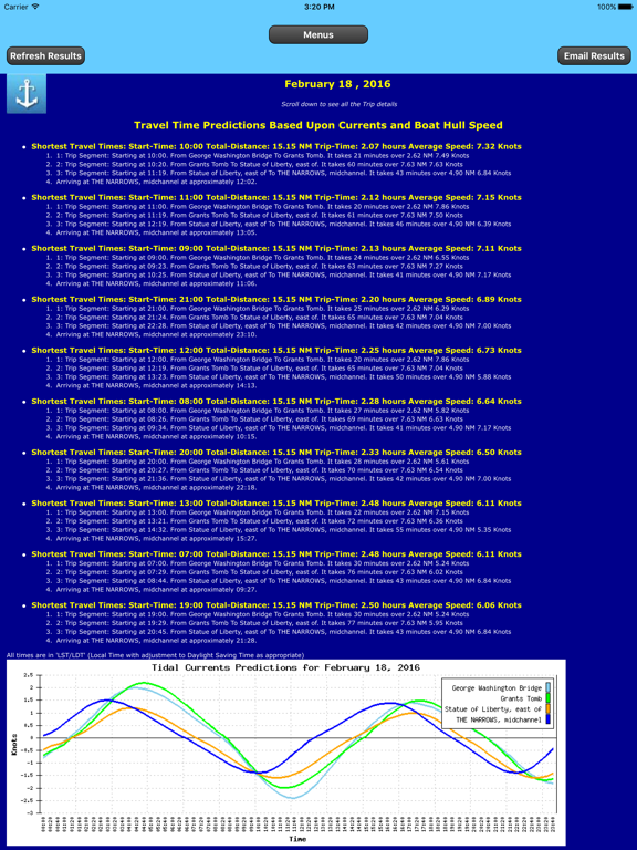
And now for the power of this app… You will be given a few choices on what time you should leave and what time you will arrive based on the tidal currents from the start of your trip to the end. Pick the quickest trip and save time and money on fuel!
The results will show you multiple times when you should start your trip and will estimate how long it will take you.
The tidal currents are plotted and displayed for you to verify the results. This helps you to fine-tune your next boating trip.
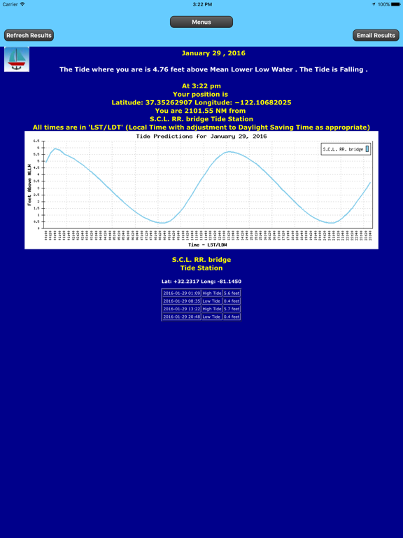
=== Using GPS to find Tides (Hi/Low) at your Position: ===
Using your Smartphone or Tablet’s built-in GPS, this app will find the two closest tide stations to
calculate your present tide based on your GPS position.
You can quickly refresh your boat’s tide based on the updated GPS reading by touching one button.
=== Finding Tides (Hi/Low) at a Tide Station Based on Date: ===
After selecting a date, you will see a single Tides station's details. You can drag the map to display the desired region then tap a Tides station marker.
=== Using GPS to find Tidal Currents at your Position: ===
Using your Smartphone or Tablet’s built-in GPS, this app will find the two closest tidal current stations to calculate your present tidal current based on your GPS position.
You can quickly refresh your boat’s tidal current based on the updated GPS reading by touching one button.
=== Finding Tidal Currents at a Tidal Station Based on a Date: ===
After selecting a date, you will see a single tidal current station's details. You can drag the map to display the desired region then tap a tidal station marker.
Show More
最新版本1.91更新日誌
Last updated on 2020年06月02日
歷史版本
Now works with iOS 12, iOS 13, iPad 11 and iPad 12.9
Show More
Version History
1.91
2020年06月02日
Now works with iOS 12, iOS 13, iPad 11 and iPad 12.9
1.90
2020年04月14日
Now works with iOS 12 and iOS 13
1.73
2019年03月24日
Minor bug fixes.
1.6
2016年06月04日
Change the Trip Planner Hull Speed Selector to use an iOS Picker that allows Hull Speeds to be selected from 3.0 to 25.0 knots.
1.4
2016年02月13日
East Cst Planr +Currents+Tides FAQ
點擊此處瞭解如何在受限國家或地區下載East Cst Planr +Currents+Tides。
以下為East Cst Planr +Currents+Tides的最低配置要求。
iPhone
須使用 iOS 8.1 或以上版本。
iPad
須使用 iPadOS 8.1 或以上版本。
iPod touch
須使用 iOS 8.1 或以上版本。
East Cst Planr +Currents+Tides支持英文


