The Hikeserwan mobile app was developed to encourage all nature lovers to hike in the beautiful trails of the Keserwan region.
The app inspires users with different trails, routes and maps for their upcoming outdoor adventures. Hikers can find their perfect trails across the Keserwan region and get up to date information about each route.
The app will grow to include more trails and features for outdoors enthusiasts to discover.
Available features:
Keserwan trails and maps:
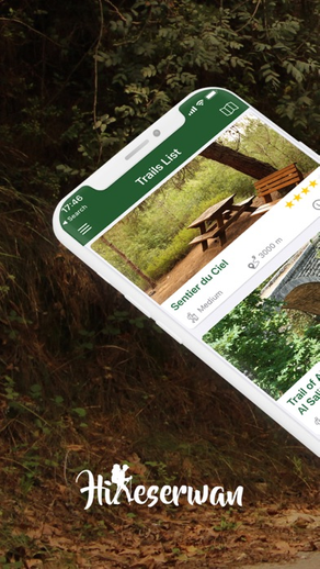
Browse through the beautiful hiking trails of Kesrewan region and get live accurate tracks on map. Get informed with trail difficulty level, duration, distance, starting/ending points, parking details along with photos & itinerary description
Record path:
Show your position and trail direction, record your path and take pictures while hiking. You can also record custom paths anywhere during your future outdoor activities.
Points of interest
An extensive directory of historical sites, tourist attractions, campsites, nearest guest houses/hotels, restaurants, local guides and more.
Saved trails:
Check the previously recorded trails and play back your path. In “My Trails” section you can view the distance you traveled, the duration and all photos that were taken.
SOS:
An SOS button for urgent situations that will immediately dial the Kesrerwan Ftouh Federation police emergency number and share your location.
Rating and reviews:
Rate trails, write your reviews and share your activities with others.