CORVALLIS MICROTECHNOLOGY, INC.
Developer
14.7 MB
Size
2024年02月08日
Update Date
Navigation
Category
4+
Age Rating
Age Rating
iCMTGIS III 螢幕截圖
About iCMTGIS III
iCMTGIS III is a professional GPS/GIS mapping app that will let you record Points, Lines and Area Features with date/time stamp and pre-defined or manually added descriptions. You could also digitize Features on top of a background map or create points by entering angles and distances. LLA, UTM, State Plane and local coordinate systems supported.You could record your track while performing other tasks using this app. View distances and areas on the spot. Stakeout to points or along a Line or Area Feature. Easily import/export Shapefiles, send/receive files via ftp or email, and store files in the Cloud. Effectively collect data and increase productivity for utilities, natural resources, land management, archeology and other GPS/GIS applications. Please note: Location data depends on the GPS receiver used. Continued use of GPS running in the background can dramatically decrease battery life. iCMTGIS III will let you easily toggle the built-in GPS on or off. This app comes with a built-in help file.
Requires iOS 9 or newer version of iOS.
iCMTGIS III provides the following enhancements over the iCMTGIS II GPS/GIS Data Collection app.
1. Ability to load geo-referenced .tif file as off-line background image for GPS mapping
2.Ability to enter Antenna Height and specify incoming GPS datum for RTK data collection
3. Distance mode for offset GPS data collection
4. Classify Features on a Topic layer
5. Export Shapefiles into a folder; import Shapefiles from a folder
6. Import/Export Feature data in Excel, DXF, KML formats
7. Export Feature data to GPX
8. Import/Export Text Files (with fixed-length field option) for Point Topics
9. Photo support
10. Point Stakeout and Line Stakeout functions.
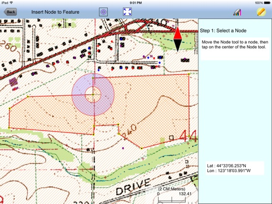
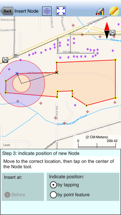
11. Insert node or Delete node to modify a Line or Area
12. Join or Disconnect Line/Area
13. Nested Point defaults to last used Point Topic.
14. New Feature List format with symbol/pattern support
15. Ability to add built-in Attributes for a Topic
16. Sort/Search/Batch Delete Features and view statistics
17. Create deed plot by entering Deed Calls
18. Export to PDF
Show More
最新版本1.2.3更新日誌
Last updated on 2024年02月08日
歷史版本
Fixed issues relating to Create Grid and displaying distances on deed plot.
Show More
Version History
1.2.3
2024年02月08日
Fixed issues relating to Create Grid and displaying distances on deed plot.
1.2.2
2023年11月30日
Updated app for iOS 7 compatibility.
1.2.1
2023年09月20日
Fixed issue that caused the error message "number of shapes does not match the number of table records" to be generated when trying to open exported Shapefiles in ArcMap. This error occurred with Job files that contain digitized Features without assigned Attribute Values.
1.2.0
2023年04月09日
Fixed compatibility issues caused by the screen size of the various newer iOS device models.
1.1.9
2022年09月12日
Coordinate Information screen update.
1.1.8
2020年08月07日
1. For importing from an Excel file, added the ability to detect decimal numbers used as Feature IDs.
2. Bug Fix: Default Value not working when built-in Attribute is added in iPhone version.
3. Bug Fix: The default blue dot was used for GPS data collection rather than the point symbol selected by the user.
2. Bug Fix: Default Value not working when built-in Attribute is added in iPhone version.
3. Bug Fix: The default blue dot was used for GPS data collection rather than the point symbol selected by the user.
1.1.7
2019年03月06日
Fixed document configuration issue.
1.1.6
2018年11月20日
Shifted the icons at the top so they won't run into the controls on the iPhone X, iPhone R, iPhone XS, and iPhone XS Max devices.
Added enhancement to the text file import and export functions. Whereas text file import was limited to importing text files ending in .txt, now the user may choose the .txt or the .csv file name extension. For text file export, instead of exporting all of the Attributes for the Topic, the app now provides a dialog to let the user select specific Attributes to be exported.
Added enhancement to the text file import and export functions. Whereas text file import was limited to importing text files ending in .txt, now the user may choose the .txt or the .csv file name extension. For text file export, instead of exporting all of the Attributes for the Topic, the app now provides a dialog to let the user select specific Attributes to be exported.
1.1.5
2016年06月15日
1. Allow GPS data collection to continue in the background when user presses the Home button or when screen is locked.
2. Display same elevation data in Feature Properties screen and the pop-up in Map View.
2. Display same elevation data in Feature Properties screen and the pop-up in Map View.
1.1.4
2016年04月01日
1. Fixed a Sheet View crash bug.
2. Newly added Features will be displayed at the top of Sheet View instead of at the end of the list of Feature records.
2. Newly added Features will be displayed at the top of Sheet View instead of at the end of the list of Feature records.
1.1.3
2016年02月04日
1. Added auto-save capability to automatically write newly added Point, Line and Area Features to Job file.
2. Added ability to import text file for Point Features containing GPS Date and Time fields.
3. Added Sort Feature icon in Sheet View for the iPad version.
4. Added Undo tool for Add Point Manually for the iPad version.
2. Added ability to import text file for Point Features containing GPS Date and Time fields.
3. Added Sort Feature icon in Sheet View for the iPad version.
4. Added Undo tool for Add Point Manually for the iPad version.
1.1.2
2015年10月15日
1. Fixed bug in recorded time based on data collection time mode.
2. Added ability to display date in accordance with the Region setting.
3. Added filter for exporting Point Feature data to text file based on Feature ID.
2. Added ability to display date in accordance with the Region setting.
3. Added filter for exporting Point Feature data to text file based on Feature ID.
1.1.1
2015年08月24日
1) Add Date and Time to Built-in Attributes List
2) Enhance Job/FTP to also list .png files
3) Under Feature Properties show Date and Time
4) Fix iCloud photo file sharing bug
5) Permit text file import of latitudes and longitudes in degrees as well as in DMS
2) Enhance Job/FTP to also list .png files
3) Under Feature Properties show Date and Time
4) Fix iCloud photo file sharing bug
5) Permit text file import of latitudes and longitudes in degrees as well as in DMS
1.1.0
2015年06月25日
1. Support universal devices
2. Fix XLS export bug
2. Fix XLS export bug
1.0.0
2015年05月06日
iCMTGIS III 價格
今日:
HK$ 1,488.00
最低價格:
HK$ 1,488.00
最高價格:
HK$ 1,588.00
iCMTGIS III FAQ
點擊此處瞭解如何在受限國家或地區下載iCMTGIS III。
以下為iCMTGIS III的最低配置要求。
iPhone
須使用 iOS 9.0 或以上版本。
iPad
須使用 iPadOS 9.0 或以上版本。
iPod touch
須使用 iOS 9.0 或以上版本。
iCMTGIS III支持英文


