Age Rating
iMariner Offshore 螢幕截圖
About iMariner Offshore
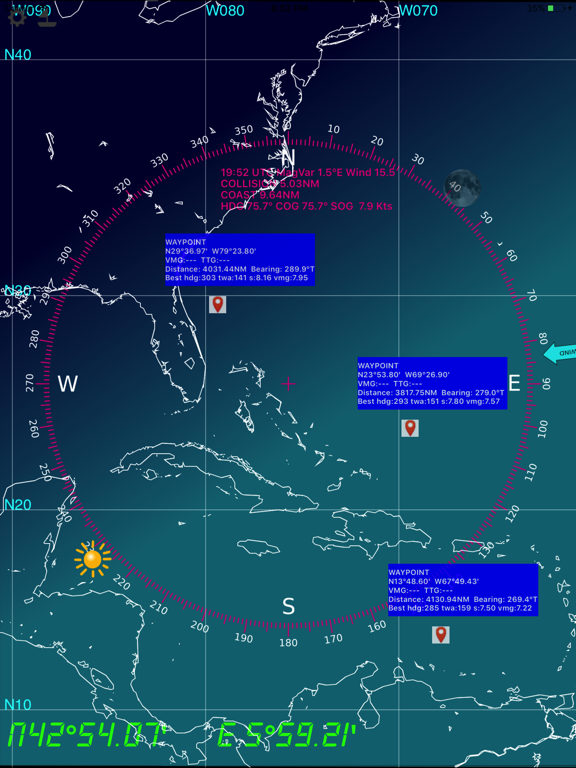
Prepare your navigation and your landings : includes GSHHS shore lines, major lighthouses, GPS, AIS, magnetic variation, position of Sun and Moon, logbook.
Note : AIS display requires an AIS/Wifi gateway
-------
AIS : AtoN, MOB, ships
-------
WayPoints
-------
Also embedded are the USCG database and NGA database of all marine lights around the world, that have a nominal range of 10 or more Nautical Miles.
IMPORTANTE NOTICE : Mariners should consult all sources of information they have before engaging their vessel to an unkwnow area, in particular notices to mariners.
NOTICE : NGA and USCG lights databases have been extracted in Feb 2013. This application will be updated in a regular basis.
-------
All major ligthhouses (landing) that have a distance at least 15 NM for the following countries :
Full world coverage.
--------
- based on the NOAA's GSHHS Shoreline Database Version 2.2.0
- world coverage from 75°S to 75°N (poles excluded)
- zoom in and zoom out : automatically selects between the 5 GSHHS databases : full, high, intermediate, low, crude
- mercator projection
- Precise positioning of your boat and other vessels (NMEA GPS and AIS frames)
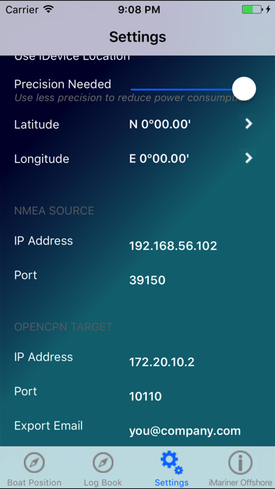
- you need a NMEA Wifi connection (TCP or UDP) with a NMEA repeater like Digital Yacht's iAIS
- log book (date,time,latitude,longitude,COG,SOG,Heading,Log,Water Depth,
TWA,TWS,Leeway,Stream Set, Stream Drift and your comments
- log book organized in passages
- log book export via email (csv format)
- NMEA protocol debug window
- magnetic variation computed with the algorithms from the NOAA's World Magnetic Model
- distance to coast
- distance to others vessels
- 'goto boat' function
- double tap for full screen display
- integrated solar compass : the rose displays the sun and moon positions in real time
Show More
最新版本4.1更新日誌
Last updated on 2021年07月21日
歷史版本
- fix some display issues when in landscape
- SOG much more visible
- Text in white
- Don't display wind if info is not available
- Udp broadcast support (without ip address)
- SOG much more visible
- Text in white
- Don't display wind if info is not available
- Udp broadcast support (without ip address)
Show More
Version History
4.1
2021年07月21日
- fix some display issues when in landscape
- SOG much more visible
- Text in white
- Don't display wind if info is not available
- Udp broadcast support (without ip address)
- SOG much more visible
- Text in white
- Don't display wind if info is not available
- Udp broadcast support (without ip address)
4.0
2021年06月12日
Rework for new AppStore standards.
3.4
2017年10月02日
Corrects an issue with GPS notifications in iOS11
Tested with Vesper Marine XB-8000
Tested with ShipModule Miniplex-3
Tested with Vesper Marine XB-8000
Tested with ShipModule Miniplex-3
3.3
2017年02月21日
Compatibility with VesperMarine XB-8000 AIS/Wifi gateway
Output $--RMB messages to an autopilot
Output $--RMB messages to an autopilot
3.2
2016年05月13日
- double finger press to display AIS targets information
- single finger press to add/remove WP
- AIS age
- MOB, EPIRB, SART
- Wind speed
- WP, bearing, distance, VMG, TTG
- AtoN (AIS type 21)
- single finger press to add/remove WP
- AIS age
- MOB, EPIRB, SART
- Wind speed
- WP, bearing, distance, VMG, TTG
- AtoN (AIS type 21)
3.1
2015年12月15日
64-bits version for iOS9
3.0
2014年09月11日
* Rotate the WIND image as an indicator of the wind angle (unless this information is retreived by NMEA).
* A line indicates the true heading
* A line indicates the COG
* A scale indicates where your ship will be in 1,2,3,4 and 5 hours
* A line indicates the true heading
* A line indicates the COG
* A scale indicates where your ship will be in 1,2,3,4 and 5 hours
1.5
2013年12月12日
Complete world coverage of major nautical lights (all areas).
iOS7 and iOS6.1 support
iOS7 and iOS6.1 support
1.4
2013年11月05日
Fixes display issues with ios7 and iPhone 5.
Adds COG and SOG.
Adds COG and SOG.
1.3
2013年02月14日
NGA and USCG lights worldwide database for lights >= 10NM
1.2
2013年01月25日
All major ligthhouses (landing) that have a distance at least 15 NM for the following countries :
US east coasts (thanks to NOAA S-57 data) and Cuba,
France Atlantic and Mediteranean coast, Corse, Portugal includiong Gibraltar, North Atlantic Islands (Acores, Canarias, Madera),
Caraibans, Panama (Atlantic and Pacific Coasts), Colombia to French Guiana
South Pacific Islands (thanks to msi.nga.mil-List of Lights)
Work is in progress for a world coverage : updates are of course free for you !
iOS5 and iOS6 compatible
1.1
2012年06月08日
We have fixed this issue in the iPad display.
We have rewrite the code handling the Passages. This version is in testing phase.
Added export in KML format, for displaying your passages in Google Earth.
Added internal GPS accuracy (Settings).
We have rewrite the code handling the Passages. This version is in testing phase.
Added export in KML format, for displaying your passages in Google Earth.
Added internal GPS accuracy (Settings).
1.0
2012年04月29日
iMariner Offshore 價格
今日:
HK$ 118.00
最低價格:
HK$ 108.00
最高價格:
HK$ 118.00
iMariner Offshore FAQ
點擊此處瞭解如何在受限國家或地區下載iMariner Offshore。
以下為iMariner Offshore的最低配置要求。
iPhone
須使用 iOS 9.0 或以上版本。
iPad
須使用 iPadOS 9.0 或以上版本。
iPod touch
須使用 iOS 9.0 或以上版本。
iMariner Offshore支持英文


