New Indonesia chart and bug fixes.
Fixed issues with NOAA charts
Improved chart appearance and bug fixes.
Bonjour! This release includes the launch of the all-new iNavX Professional+ France charts, and also brand new charts for Croatia, Romania, and Spain!
The iNavX Professional+ series of charts delivers country-specific hi-res vector charts.
Buongiorno! This release includes the launch of the all new iNavX Professional+ Italy charts. The iNavX Professional+ series of charts delivers country specific hi-res vector charts.
We update iNavX as often as possible to make it faster and more reliable to you. Here are couple of the enhancements you’ll find in the latest update:
– Improvements to the iNavX Professional+ Netherlands charts
– Squashed some bugs
Summer is upon us so this is a quick update to iron out a few wrinkles and ensure iNavX is perfect for any and all adventures!
We’re excited to announcement the expansion our iNavX Professional+ chart portfolio with the new introduction of charts for the United Kingdom and Ireland.
We’re excited to announcement the expansion our iNavX Professional+ chart portfolio with the new introducuction of charts for Australia, New Zealand and Chile.
New iNavX Professional+ Slovenia Chart.
Small fixes and improvements
Introducing new iNavX Professional+ Greece. One chart covering all Greek waterways.
This is a special release!!
We are proud to announce the expansion of the iNavX Professional+ Chart series with the additional of +30 new charts.
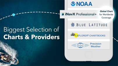
The iNavX Professional+ Charts are hi-res vector charts specifically for iNavX. Sourced from hydrographic offices, these vector charts are optimized for online and offline use.
Explore Charts for the US, Canada, Greece, Denmark and many other countries.
As always, if you have any questions or feedback, we love to hear from iNavX users, so please email us at support@inavx.com
This is a special release!!
We are proud to announce the expansion of the iNavX Professional+ Chart series with the additional of +30 new charts.
The iNavX Professional+ Charts are hi-res vector charts specifically for iNavX. Sourced from hydrographic offices, these vector charts are optimized for online and offline use.
Explore Charts for the US, Canada, Greece, Denmark and many other countries.
As always, if you have any questions or feedback, we love to hear from iNavX users, so please email us at support@inavx.com
Another fantastic update to improve your experience using iNavX. We are always working hard to make iNavX the best marine navigation app on the market and this includes lots of little tweaks and improvements. We hope you enjoy this latest build.