Japan Mt.1000 is a app that climbing the Japan of hundred famous mountains.
Climbing to registered mountains, you can record it and climb to arrive near the summit.
This application summit data of 1063 have been housed.Summit data is based on the 1059 summit,
which is published in the Geographical Survey Institute 'mountain altitude list of Japan (1003 mountains)',
three hundred famous mountains of 4 summit (Futamatayama, Suwayama, Fujiwara Takeshi, Azuma) was added to thing.
Geographical Survey Institute (http://www.gsi.go.jp/KOKUJYOHO/MOUNTAIN/mountain.html)
■Confirm location
Map of the area around the current position is displayed.
You can record climbing if it is within 100 meters(328 feet) of the top.
■Climbing diary
When climbing to record can be entered in the diary.
■Radar
You can check the radar the direction of the mountains from the current position.
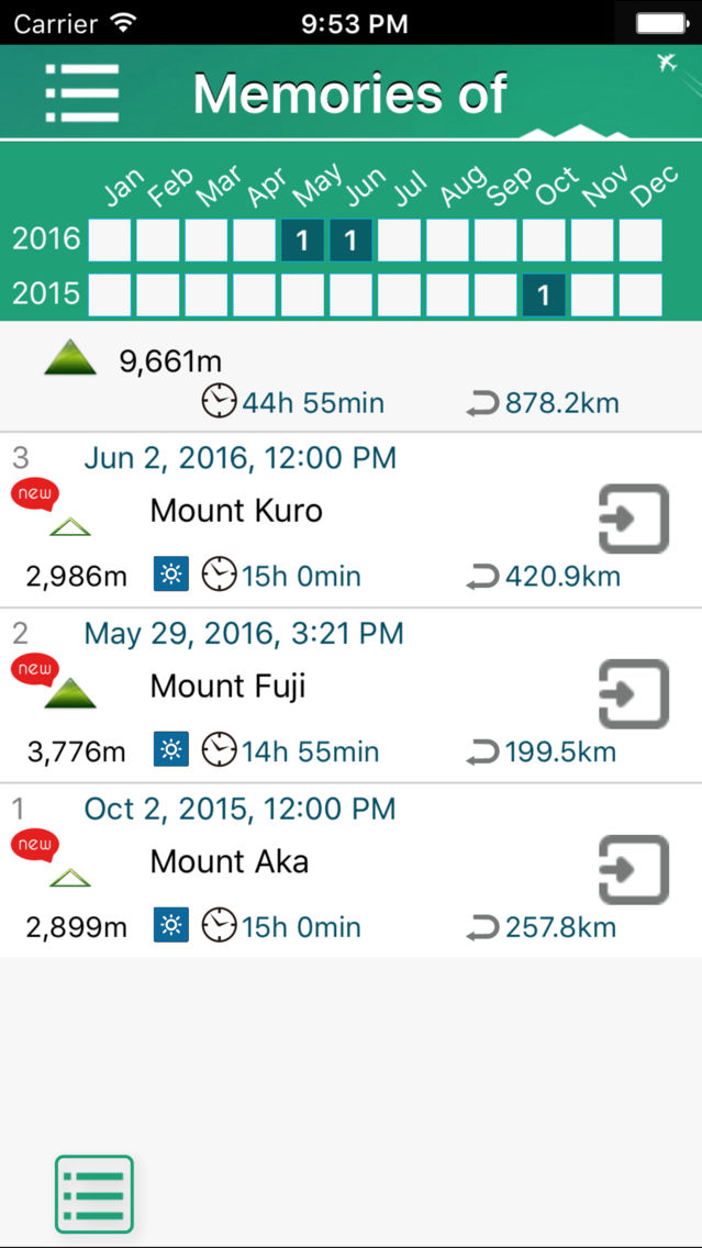
■Memories of
Maps displayed with photos stroke to return home from starting.
Photograph is the target that was taken in time of up to return home from starting to have been saved in the camera roll.
■Share
Climbing record for each mountain (climbing position information, climbed date, nickname) you can publish.
When you publish a climbing record, it will enable further posting of messages.
■Export
You can copy all of the climbing record data to send mail in CSV format, or to clip.
■iCloud Backup
You can back up the Climbing record data to iCloud for iPnone/iPad model change.
■Migration
If already you have 'Japan Mt.100', it is possible to migrate the climbing record of 'Japan Mt.100' in this application.
■Mountains that are housed
□Hokkaido
Mount Rishiri , Mount Rausu , Mount Shari , Akan Volcanic Complex , Daisetsuzan Volcanic Group ,
Mount Tomuraushi , Mount Tokachi , Mount Poroshiri , Mount Yōtei
□Tohoku
Mount Iwaki , Hakkōda , Mount Hachimantai , Mount Iwate , Mount Hayachine , Mount Chōkai , Mount Gassan ,
Mount Asahi , Mount Zaō , Mount Iide , Mount Azuma , Mount Adatara , Mount Bandai , Mount Aizu-Komagatake
□North Kanto, Oze, Nikko
Mount Nasu , Mount Tsukuba , Mount Hiuchigatake , Mount Shibutsu , Mount Hotaka , Mount Akagi ,
Mount Nantai , Mount Nikkō-Shirane , Mount Sukai
□Joetsu, Shinetsu
Mount Echigo-Komagatake , Mount Hiragatake , Mount Makihata , Mount Tanigawa , Mount Naeba , Mount Amakazari ,
Mount Myōkō , Mount Hiuchi , Mount Takatsuma , Mount Motoshirane , Mount Azumaya , Mount Asama
□South Kanto, Chichibu, Tama
Mount Ryōkami , Mount Kobushi , Mount Kinpu , Mount Mizugaki , Mount Kumotori , Mount Daibosatsu ,
Mount Tanzawa , Mount Fuji , Mount Amagi
□Northern Alps
Mount Shirouma , Mount Goryū , Mount Kashima Yarigatake , Mount Tsurugi , Mount Tate , Mount Yakushi ,
Mount Kurobegorō , Mount Kuro , Mount Washiba , Mount Yari , Mount Hotaka , Mount Jōnen , Mount Kasa ,
Mount Yake , Mount Norikura
□Central Alps
Utsukushigahara Highland , Mount Kirigamine , Mount Tateshina , Mount Aka , Mount Ontake , Mount Kisokoma ,
Mount Utsugi , Mount Ena
□Southern Alps
Mount Kaikoma , Mount Senjō , Mount Hōō , Mount Kita , Mount Aino , Mount Shiomi , Mount Warusawa ,
Mount Akaishi , Mount Hijiri , Mount Tekari
□Hokuriku, Kinki, Chugoku, Shikoku
Mount Haku , Mount Arashima , Mount Ibuki , Mount Ōdaigahara , Mount Ōmine , Daisen , Mount Tsurugi ,
Mount Ishizuchi
□Kyushu
Mount Kujū , Mount Sobo , Mount Aso , Mount Kirishima , Mount Kaimon , Mount Miya-no-ura
■Caution
"Confirm location" and "Radar" will use the gps.
Continued use of GPS running in the background, will be reduced dramatically battery life.