• Flight logger: Records active aircraft profile when no plan is loaded
• Flight logger: Increase GPS timeout from 5 to 10 minutes
• Added support for ForeFlight Sentry Carbon Monoxide (CO) in app alerts
• Support KMZ bundled images, icons scale with map, with other improvements
• Shortcut in settings to open GDL90 configuration page
• Import / Export (Settings->Data Management) entire app flight log as an ".ozlg" file
• Fix a potential crash in QuickPlan when deleting a bubble
• Fix a potential crash that could occur on Documents view
• Flight Logger, fix elevation calculate, caused some flights to not log or car drives to log
• Improve SmartBrief error displayed when loading fails
• Better loading of FIA frequencies that contain letter suffixes such as "123.4A"
• Fix issue where status bar may be incorrect colour on launch
• GPS Alt, show ‘—‘ if invalid accuracy, show vertical accuracy in GPS error hud box
• Fix displaying METARS (in NZ) where Visibility aren't included
• General performance and stability improvements
• Improvements to FIA NEXT searching
• Fix icon colours for waypoint action buttons
• Improved touch overlay indicator, prevent touches from sticking
• Fix crash that could occur when taping on GTAF or PDF button in SmartBrief
• Improvements to SmartBrief loading
• Fix issue where Company DB would fail to download on new devices
• Fix issue where a rogue tab or label could appear on the tab bar
• Fix for SmartBrief time slider period buttons not registering taps
• General stability and performance improvements
• Enterprise Dashboard Download Policies
• ForeFlight Sentry traffic and AHRS support
• Fixed incorrect formatting of speed and course data for 1.0 GPX tracks
• 0 can now be entered as an altitude when setting up detailed performance
• Improve Enterprise DB downloading, fixed checksum checker, added error reporting, manually download button forces a refresh
• Don't fill in wind data for altitudes below whats available (outside of NZ & AU)
• Fixed for QNH Hud, improved refreshing, reject TAFs that are over an hour old
• Add 2NM (NVIS) option to 'LSALT boundaries'
• Show error message when sending to Dynon SkyView fails
• Fix issue where ScratchPad could error when creating a PDFPack
• Fix showing certain CTAF frequencies in waypoint view
• User Data in support emails includes 7 days of app logs
• Stability and performance improvements
• Fix issue with LSALT assistant that could show "None Found"
• Fill in IFR route when found and during adding and removing waypoints
• Reset to max/default fuel, only if a refuelling point in a plan sheet when changing aircraft profiles
• Rename “Default” badge to “Active” for Aircraft, W&B and Pilot settings
• Improve handling of user waypoints (importing and displaying), mostly where the code wasn't unique
• Improve performance of NOTAM rating user experience
• Fix issue where weight and balance load sheets could reset when inserting and removing waypoints
• Fix issue where Basic brief wouldn't show plan weather
• Improvements to handling GDL90 devices and autopilot commands (iLevel improvements)
• Fix display glitch showing ETI +time label on plan sheet header
• Fix a PDF pack UI lockup
• Fix issue where TOD shown incorrectly on app restart
• Fixed frequency table not showing complete information outside of AU or NZ
• Fix iPad 10 status bar colour issue
• General stability and performance improvements
Features:
• Added visible markings for MTOW, Max Ramp Weight, Max Zero Fuel Weight, and Max Landing weight to the Weight and Balance envelope in Aircraft Profile.
• Added OAT to Altitude Optimiser.
Improvements:
• Flight plans with stopovers will have the stopover times retained when sharing a flight plan.
• Custom waypoint details (name, elevation, notes, etc) are now shareable with other devices via gpx.
• Improved the filtering and sorting of waypoints in the QuickPlan suggestions.
• iPhone HUD is now the same colour as the iPad.
Bug Fixes:
• Fixed an issue where some CSV files wouldn't import
• Fixed SmartPlate overlay when the system is in Dark Mode, but OzRunways is set to Light Mode
• Fixed an issue where some charts wouldn't print properly.
• Fixed Plan Sheet ETA time picker. It will no longer be cropped when using a large plan.
• Fixed an issue where the iPhone Pro Max would hide the "done" button when viewing map settings in landscape mode.
• Fixed an issue where the "Recenter On Map" button wouldn't work from the User Waypoint screen.
• Fixed QNH values not being found in the GPS HUD when multiple regions are active.
• Fixed label layout issue in legacy airfields list when system font size is set to large.
• Various minor bug fixes.
== V12.0.4 ==
Features:
• Added a new view for simultaneously managing the deletion and export of multiple log files.
Improvements:
• Updated the BoM radar list. Richmond(QLD) has a new radar and removed Eucla & Tennant Creek.
• Enhanced the visibility of the W&B stations reorder button by changing its colour.
Bug Fixes:
• Resolved an issue causing incorrect date and time updates in-flight log entries.
• Fixed a crash occurring in Scratchpad when generating PDFs.
Merry Christmas to all from the OzRunways team!
• Fix where traffic bubbles wouldn't show
• Introduced a new ‘Manage Logs’ window for easier handling of saved flight logs
• Improved flight log time editor layout for better usability
• Integrated NOTAMs airspaces into the main map
• Fixed the plan sequencer for manual selection of active leg
• Fixed dark mode text visibility for SmartBrief wind overlay
• Fixed crash when changing fuel units in aircraft profile
• Fixed hiding of hidden NOTAM icons
• Restoration of custom icons for organisations
• SmartBrief weather selection bug fix
• General performance and stability improvements
- Better support for Class C CTA/CTR's activated by NOTAM
- Make some smaller PRD areas easier to see highlighted on-map
- Fix inverted plans not updating on plan summary page
- Better hide LSALT splay when not needed
- Hide the system buttons for Live Text Recognition on approach charts
- Fix NOTAM button colours
Better NOTAMs!
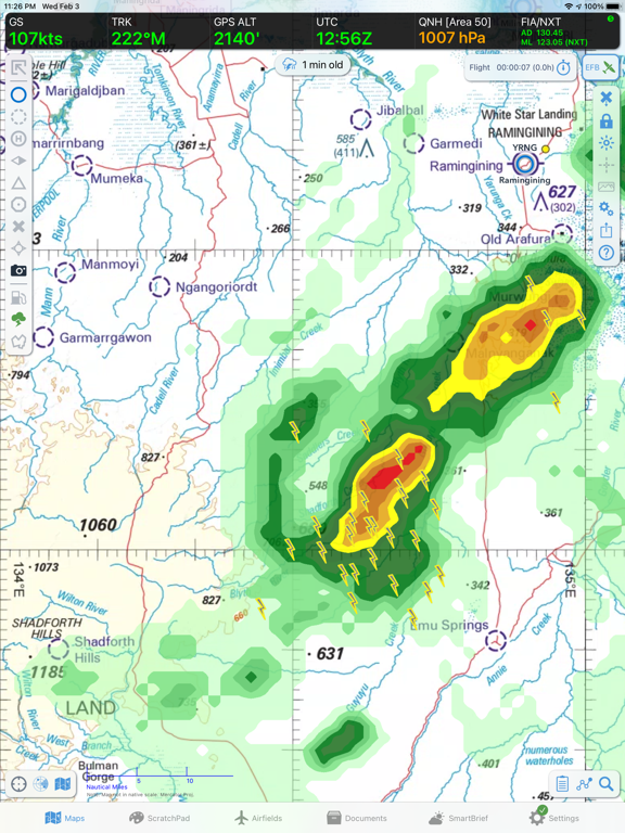
• New NOTAMs screen in SmartBrief! NOTAMs are drawn on the map with category icons and associated activity areas
• Filter NOTAMs by category, sort by priority
• Restricted Airspaces and Danger Areas, including those activated by NOTAM are drawn on the map
• Airspace activation status follows time slider. Red = active at selected time. Orange = will activate within 1 hour.
• Relative airspace activation times are listed in the details ("Active in X hours")
• Translate NOTAMs into plain text with Artificial Intelligence (AI) interpretation
• Hide unwanted NOTAMs with the tap of a button. Hidden NOTAMs do not appear on the map.
• Plan segments/legs show active NOTAMs and Airspaces for the duration of your plan. Only NOTAMs that intersect with your plan are included.
• PDF Pack option to include NOTAMs that intersect with your route and selected LSALT splay.
• Main Map screen shows live restricted, danger, and temporary restricted airspaces. Orange shading = active within 1 hour. Red shading = currently active.
• 'Hidden NOTAMs' list includes NOTAMs that cannot be drawn geographically, such as FIR NOTAMs or document amendment NOTAMs etc.
General Improvements & Fixes
• Dark Mode: added support for dark plates, documents and maps (ERCs/TACs/OpenStreetMap/PCA only)
• PDF Pack and SmartBrief route segment now show significant weather that intersects with your plan
• SmartBrief now shows an alert when plan ETD is in the past, option to set ETD to 'now'
• Fixed an issue in Plan Sheet where LSALT 'fill down' button wasn't working
• Experimental: Added iLevil auto pilot support
• Added support for more full text words in SPECI/METAR
• Prioritise SPECI over eAWIS
• Added highlighting for weather phenomenon, e.g. +SHRA, FU, DZ, TSGR
• Fixed an issue in SmartPlates where GS/RoD data didn't work correctly when using certain external GPS devices
• Filter out duplicate 'CUSTOM' Air-Route suggestions where they duplicate the existing H/L options
• Don't show 'CUSTOM' air route suggestions where the distance is 20% greater than DCT
• Fixed a bug where scrolling with a mouse could go out of bounds
• W&B UI improvement: replace locked station symbol with a lock icon instead of a greyed out check mark
• Fixed a stability issue with the date/time picker when iOS font size set to maximum
• Fixed an issue where names in KML overlays list could be truncated
• Fixed Settings → Logs map interaction issue that could inadvertently invoke the sidebar
• Fixed an issue in Plan Sheet where LSALT 'fill down' button wasn't working
• Preserve plan name on GPX export and import
• Map engine sprite optimisations
• SmartBrief improvements when loading multiple regions
• Clarified some NAIPS submission text around NOSEND usage
• Remove inbuilt screen brightness slider & associated buttons; dark mode maps and plates make it redundant. (Use system control to adjust brightness instead)
• Fixed an issue where active leg may not be active if split (e.g. diversion)
• Update NAIPS POB Default to "TBN" (old: "TBA")
• SmartPlates ON by default for supported subscriptions
• UI tweak on SmartPlates to show a more prominent blue dashed line
• Fixed coordinate formatting for IFIS plan submissions
• Fixed an issue where SmartBrief Database wouldn't load immediately after an app reinstall
• Aircraft 'Detailed Performance' table now exports 'cruise burn' and 'climb burn' values correctly, requires OzRunways v11.1.4 or greater to import
• Fixed some Latin American translation errors
• When editing W&B of an Aircraft Profile, a W&B envelope will be auto created if one does not exist
• Prevent in-app purchase when device is not assigned to an account
• Various improvements and fixes
Fix issue with some runway diagrams in New Zealand
Fix issue with Scratchpad sometimes loading the wrong template
Fix charts sometimes appearing with yellow overlay after app minimised
Better looking labels on ruler (don't jump around as values change)
Don't allow use of 8 and 9 digits when setting ADSB Squawk codes
Fix ADSB sometimes not hiding aircraft above 15,000 ft
Tweak to scratchpad visuals
Fix visual glitch in date picker
Fix crash in Plan Spreadsheet clicking on REV and ATA notes fields
Fix bug on older iOS 14 devices
Live text recognition on Approach Plates (requires iOS 16)
Sort Document folders with EnterpriseDB Folders green at the top
SmartPlates better support arcing and ILS approaches
ADSB Traffic: Show your own aircraft as green
Faster weather radar tiles
Fix visual anomaly when switching approach charts in Dark Mode
Fix Enterprise Dashboard documents with custom to/from validity using the wrong timezone
Fix NAIPS when exporting a multi-stage flight plan, with one leg that has AWK
Fix crash on iOS17 in Aircraft Detailed Performance section
Fix crash in Quick-Plan
Fix Chart Selection list sometimes showing a tick on the wrong item
Fix NZ Preflight sometimes using old credentials after changing login
Fix NAIPS Wind/Temp profile for flights above F450
Remove subscription requirement for eAWIS
Fix issue where duplicating Aircraft would sometimes not refresh UI
Fix "Clear Track History" re-appearing after app restart
Fix bug where new plans would recenter incorrectly on some devices
Better grouping of NZ SID/STAR plates into the appropriate group in Airfields Improvement
Performance improvements
Make Enterprise Dashboard folders a different colour in Settings > Documents
Aircraft own-ship icon in DAPS fades/disappears if poor GPS signal
Fix plain text TAF decode for "TL" > "Till"
Fix some W&B text clipped
Fix Cursor Terrain showing "404" label instead of "Ocean"
Fix crash in Settings > Information
Fix BULLSEYE range arcs rendering distance
Update Gove BoM Radar details
- Fixed an issue importing old Aircraft profiles with 'detailed performance table' climb and cruise burn figures. If in doubt, update to this release then check your figures.
- Frequency navigator NDB optimisations
- Added padding to move Weight & Balance limit text below the graph
- Support for more RNAV approaches via rubber-band
- New Zealand frequencies (tap on map)
- METAR text highlights any rainfall last 10mins for awareness
- METAR text highlights Temp/Dewpoint that are within 1ºC of each other
- NVFR LSALT splay type can use RNP2 Published value
- Improved performance & battery life
- Bug fixes
- Performance and battery improvements
- Fix DAPS drawing controls being obscured by the timer icon (if enabled)
- Fixed some labels showing am/pm during 24hr time
- Fix for ADSB Visible Traffic showing zero in Settings
- Remove Plain Text TAF decode button for SIGMETs in SmartBrief
- Fix sometimes OzRunways UserID wouldn't send in NAIPS RMK field
== V11.1 ==
• NEW Frequency Navigator shows associated frequencies for aerodromes & helipads when selecting a waypoint from the Closest Points popup
• Enterprise customers can now request custom ScratchPad templates
• IFR route suggestions now show total distance for each route
• Range ring selector design improvements
• ETD selector now correctly shows 24hr format
• DAP chart viewer optimisations on iPhone
• Fixed an issue where the map would unintentionally open over Antarctica
• Fixed an issue where NAIPS could return a blank screen on plan submission
• Fixed an issue where deselected Weight & Balance stations were being printed
• Fixed an issue where theme selector could display no selection
• Added “Enable Lateral Entry” toggle in Weight & Balance Profile for ease of access
• Improved password creation logic to prevent unwanted email changes
• Fix crash when downloading documents on demand
• Optimised the map overlays when rotating the map, reducing the chance of an app crash.
• Weight & Balance improvements when using fuel tables and plotting negative fuel weights
• Head Office NOTAM preference removed. Now always included in Tap-on-map Area Brief.
• Enterprise customers can now organise plans into groups from the dashboard.
• Optimised app start-up location
• CDI indicator sensitivity adjustments.
• DAPS zoom level improvements on launch
• Added option to invert colours on plates when in dark mode
• Stability improvements when retrieving plans in bad internet environments
• AIP document search function optimisations
• App launch optimisations
• Fixed an issue where the lock icon was pressed on an approach plate before the weather for the airport had loaded.
• Weight & Balance improvements when changing aircraft
• Various other UI Improvements
• Fixed: Weight and Balance configuration selector was not working in plan sheet
• Fixed: selecting a different Aircraft in the pop over wouldn’t update the Weight and Balance load sheet
• Fixed: status/loading padding on text fields (e.g. sign up screen)
• Fixed: importing a plan wouldn’t select the associated aircraft profile (if available)
• Fixed: importing plans may not include departure date