SkyDemon
免費Offers In-App Purchases
3.16.13for iPhone, iPad and more
9.5
493 Ratings
Divelements Limited
Developer
49.2 MB
Size
2024年04月01日
Update Date
Navigation
Category
12+
Age Rating
Age Rating
SkyDemon 螢幕截圖
About SkyDemon
SkyDemon is Europe's favourite software for VFR flight planning and in-flight navigation.
Use this app to access your SkyDemon subscription on your iOS device, unlocking SkyDemon's powerful features while on the move.
FLIGHT PLANNING FEATURES
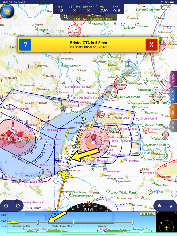
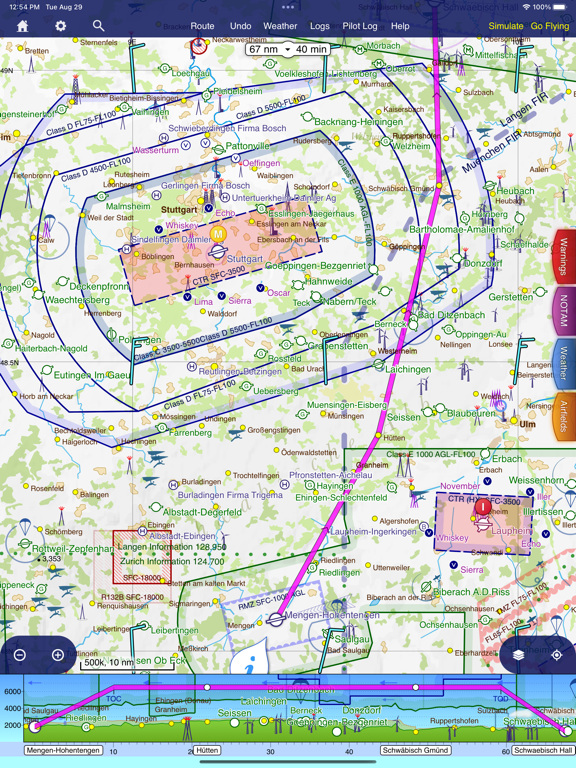
- SkyDemon vector charts are the clearest aeronautical charts you'll ever use, with dynamic airspace clipping and choice of map layers
- Route planning is as simple as touching consecutive waypoints and dragging to make changes
- Virtual Radar shows how your route relates to airspace, terrain, obstructions and other features
- Pilot Log facility calculates headings and groundspeeds from actual wind data, and shows useful frequencies
- Plates and other documents for relevant airfields are displayed automatically as you plan, and many are available georeferenced for use in flight
- Intuitive pan, pinch and rotate support with no loss of map clarity or text legibility
- File a VFR flightplan for your route directly to air traffic controllers
- Automatic TAF, METAR and SIGMET briefing as you plan a route, with graphical decoding
- Rainfall data can be overlaid on the main map, with animation, showing the trend of rainfall over time
- Integration of GAFOR route forecasts for Switzerland, Austria, Slovenia and Croatia
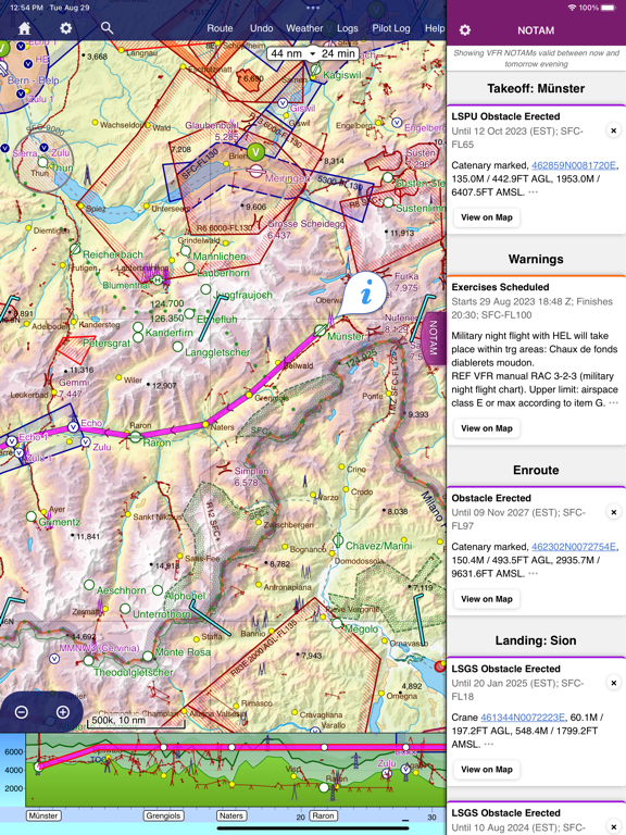
- Both narrow-route and area NOTAM briefings available, updated as you plan
- Advanced NOTAM graphical interpretation and depiction on the main map
- Easily print your PLOG and the output from various briefings
- Warnings for airspace and other potential hazards to your flight, updated in real time
- Airfield Admin Information shows useful contacts and other details for airfields featured in our charts
- Forecast winds aloft are automatically retrieved for the flight time and displayed on the map
- Create an advanced flight performance profile for each aircraft you use
- ATS Routes mode offers an alternative chart presentation for flight along airways
- Accurate fuel, weight and balance calculations including flight costings
- Create an unlimited number of user-defined waypoints
- Analyse your track logs for posterity
- Choose between six different vector chart styles
- Extensive European chart coverage as standard
GPS NAVIGATION FEATURES
- Intelligent warnings for approaching airspace, NOTAM, obstacles, terrain and other hazards
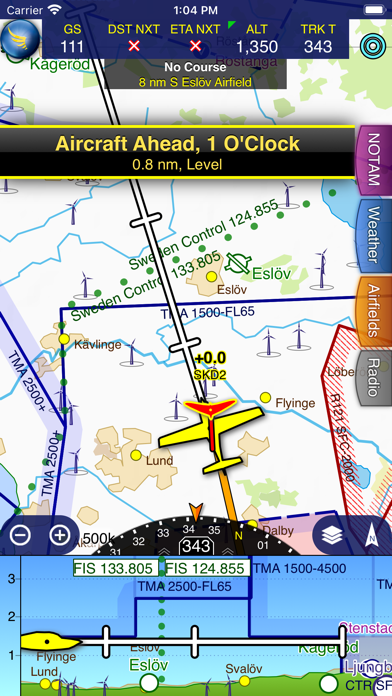
- Virtual Radar shows a side-on projection of all approaching features and how your trajectory relates to them
- Vector map automatically follows the aircraft in north up, track up or course up orientation
- Clear and concise instruments show you flight statistics and help keep you on track
- An HSI/ILS instrument helps you keep to your planned route and line up early for approach
- Live Pilot Log shows progress through your route, ETAs, ATAs and useful frequencies based on your current position
- TerrainSafe dynamically colours mountainous terrain around you to quickly identify safer areas
- Direct To allows easy re-routing in a hurry by picking from a selection of nearby airfields
- Approach Information shows runway diagrams, TAF, METAR, NOTAM and other airfield details useful for making an approach
- Live updates of TAF and METAR while in flight, with associated alerts*
- Extended runway centrelines appear automatically on the map as you near your destination airfield
- Permanent display of position relative to nearest well-known waypoint, for position reporting
- Easy changing of the planned route while in flight by touching and dragging
Continued use of GPS running in the background can dramatically decrease battery life.
* Internet connection required for live weather update while in flight
Show More
最新版本3.16.13更新日誌
Last updated on 2024年04月01日
歷史版本
- The new Explore Heatmap tool allows you to create and explore heatmaps from all your logged flights
- Many improvements to memory consumption, speed of loading data and speed of drawing maps
- Many improvements to memory consumption, speed of loading data and speed of drawing maps
Show More
Version History
3.16.13
2024年04月01日
- The new Explore Heatmap tool allows you to create and explore heatmaps from all your logged flights
- Many improvements to memory consumption, speed of loading data and speed of drawing maps
- Many improvements to memory consumption, speed of loading data and speed of drawing maps
3.16.12
2024年02月12日
- Improvements to the High Contrast / Night chart style
- Improvements to performance while updating charts
- Improvements to performance while updating charts
3.16.11
2023年12月10日
- You can now customise the trail left by your aircraft in flight
3.16.10
2023年09月24日
- FIS boundaries are now drawn in our maps
- International borders are now highlighted in our maps
- Airspace activations by NOTAM and AUP are listed in the What's Here screen for the airspace
- International borders are now highlighted in our maps
- Airspace activations by NOTAM and AUP are listed in the What's Here screen for the airspace
3.16.9
2023年06月11日
- Terrain shading and colours have been updated to look better across Europe
- A list of recent finds is kept in the Search window
- You can now tap the wind in What's Here to see winds aloft at all altitudes
- Improvements to graphical NOTAM depiction in Eastern Europe
- The aircraft CG envelope can now be defined as a moment-mass graph
- A list of recent finds is kept in the Search window
- You can now tap the wind in What's Here to see winds aloft at all altitudes
- Improvements to graphical NOTAM depiction in Eastern Europe
- The aircraft CG envelope can now be defined as a moment-mass graph
3.16.8
2023年05月04日
- GFP file format is now included when you share a route, for Garmin GTN devices
- Virtual Radar has been updated so that while flying, more terrain below you is visible
- A sound and speech is now played if you lose the connection to your WiFi traffic receiver
- Virtual Radar has been updated so that while flying, more terrain below you is visible
- A sound and speech is now played if you lose the connection to your WiFi traffic receiver
3.16.7
2023年03月28日
- Improvements to map drawing speed
- Various minor user interface improvements
- Various minor user interface improvements
3.16.6
2023年01月23日
- Various improvements to loading speed, memory consumption and stability
- Connectivity to Avidyne IFD systems restored
- Connectivity to Avidyne IFD systems restored
3.16.5
2023年01月18日
- Various improvements to loading speed, memory consumption and stability
- Connectivity to Avidyne IFD systems restored
- Connectivity to Avidyne IFD systems restored
3.16.4
2022年10月03日
- Mac support enhanced
- Weather animations updated
- Nearby airfields offering an ATIS are now displayed in the Radio tab
- Weather animations updated
- Nearby airfields offering an ATIS are now displayed in the Radio tab
3.16.3
2022年05月23日
- Direct To Overhauled
- Waypoint Searches in Flight Sorted by Proximity
- Previous and Next Buttons in Logs
- Waypoint Searches in Flight Sorted by Proximity
- Previous and Next Buttons in Logs
3.16.2
2022年04月10日
- Sharing a route now produces files in GPX and FPL formats along with the SkyDemon format
- Scratchpad now supports Apple Pencil and a variety of drawing tools
- Improved the chart loading speed
- Scratchpad now supports Apple Pencil and a variety of drawing tools
- Improved the chart loading speed
3.16.1
2022年03月20日
- Fixed a bug concerning logging multiple takeoffs and landings within one flight
3.16
2022年03月09日
- Forecast cloud thickness is now illustrated in virtual radar when Flyable Conditions is enabled
- It is now possible to change the height of the virtual radar
- Frequency monitoring codes are detailed better in the Pilot Log and the Radio tab
- It is now possible to log takeoff manually from the Logging menu
- It is now possible to change the height of the virtual radar
- Frequency monitoring codes are detailed better in the Pilot Log and the Radio tab
- It is now possible to log takeoff manually from the Logging menu
3.15.8
2022年01月23日
- NOTAMs that are less relevant to your route have been moved to the end of the briefing
- UK GAR and police notification guidance has been updated
- Verbal alerts when a new METAR is received for an airfield of interest when flying
- UK GAR and police notification guidance has been updated
- Verbal alerts when a new METAR is received for an airfield of interest when flying
3.15.7
2021年12月07日
Some minor issues have been addressed.
3.15.6
2021年12月05日
Some minor issues have been addressed.
3.15.5
2021年10月03日
- FIXED: Some iOS 15 issues
- Depiction of NOTAMs has been improved on the main map and in virtual radar
- It is now possible to rename a turning point that is not associated with a waypoint
- References to AICs within NOTAMs are now hyperlinked
- Depiction of NOTAMs has been improved on the main map and in virtual radar
- It is now possible to rename a turning point that is not associated with a waypoint
- References to AICs within NOTAMs are now hyperlinked
3.15.4
2021年06月14日
- The Logs dropdown now prompts for feedback if you've recently flown to an airfield for which we have little data
- Find a Destination now includes badges for the most popular airfields in each country
- Find a Destination now includes badges for the most popular airfields in each country
3.15.3
2021年05月24日
- Added separate support for third-party traffic receivers Air Avionics AT-1 and PowerFLARM Fusion
- FIXED: SkyDemon could crash when opening the pilot log
- FIXED: SkyDemon could crash when opening the pilot log
3.15.2
2021年05月04日
- Military Grid Reference System (MGRS) coordinates can now be entered into the Find window
- Universal Transverse Mercator (UTM) coordinates can now be entered into the Find window
- You can now edit the aircraft registration in a track log
- Fall back to Location Services on connection failure of SkyEcho 2, Flarm or PilotAware traffic receivers
- Universal Transverse Mercator (UTM) coordinates can now be entered into the Find window
- You can now edit the aircraft registration in a track log
- Fall back to Location Services on connection failure of SkyEcho 2, Flarm or PilotAware traffic receivers
3.15.1
2021年03月24日
- Various optimisations to internet communications
3.15
2021年02月14日
- A new Flyable Conditions weather layer has been added, showing forecast weather conditions related to your own personal preferences
3.14.8
2021年01月13日
- SkyEcho 2 configuration has been improved
- A bug affecting SkyDemon on iOS 9 devices has been resolved
- A bug affecting SkyDemon on iOS 9 devices has been resolved
3.14.7
2021年01月12日
- SkyEcho 2 configuration has been improved
SkyDemon FAQ
點擊此處瞭解如何在受限國家或地區下載SkyDemon。
SkyDemon包含應用內購買。 以下為SkyDemon應用內購買價格清單。
SkyDemon iOS Subscription
HK$ 1,488.00
以下為SkyDemon的最低配置要求。
iPhone
須使用 iOS 10.0 或以上版本。
iPad
須使用 iPadOS 10.0 或以上版本。
iPod touch
須使用 iOS 10.0 或以上版本。


