Topo GPS - Topographic maps
Plan and follow gpx routes
免費Offers In-App Purchases
9.7.0for iPhone, iPad and more
Age Rating
Topo GPS - Topographic maps 螢幕截圖
About Topo GPS - Topographic maps
Makes from your iPhone, iPad, Apple Watch and/or Macbook a complete GPS device with detailed topographic maps. Viewed maps will be stored on your device so that Topo GPS can also be used offline.
Why should you buy an expensive GPS device if you can install Topo GPS? Topo GPS contains all functions of a regular GPS device for less money, has a much more detailed map, and is more convenient to operate. The accuracy of the position determination is in favorable conditions about 5 m.
Ideal for walking, hiking, cycling, mountain biking, sailing, horse-riding, geocaching, scouting, trail running and other outdoor activities. Also suited for outdoor professionals.
- Map
* To use Topo GPS you need to buy a map.
* Official topographic maps of many countries, including Great Britain (OS Explorer), New Zealand and Australia are available as in-app purchase.
* Topographic maps are very detailed maps, include height contours and are very suited for outdoor activities.
* All maps of a certain region can be made offline accessible using the map download screen.
* Easy switching between maps.
- Routes
* Recording routes, with pause and restart possibility.
* Planning routes via route points.
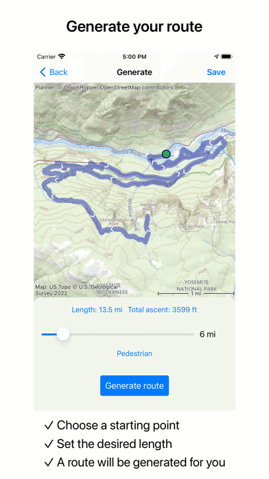
* Generating routes
* Editing routes
* Synchronization with your other devices via iCloud.
* Searching routes with filters.
* Routes can be organized into folders.
- Waypoints
* Easy adding by pressing long on map.
* Adding waypoints through address or coordinates.
* Sharing waypoints.
* Editing waypoints.
- Layers
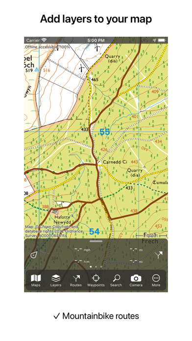
Layers contain information that can be added to and removed from the map.
* Long distance bicycle routes
* Mountainbike routes
- Coordinates
* Easy entering coordinates
* Scanning coordinates
* Supported coordinate systems:
WGS84 decimal, WGS84 degree minutes (seconds), UTM, MGRS, and other country specific coordinate systems.
* Coordinates grid layers
- Intuitive interface
* Clear menu with most important functions.
* Different dashboard panels with distance, time, speed, altitude and coordinates.
* Clear manual at www.topo-gps.com
- Supported file formats:
* gpx, kml/kmz, geojson (all also zip compressed), WFS, csv
If you are recording a route, the GPS will run in the background. Continued use of GPS running in the background can dramatically decrease battery life.
Rdzl, the company behind Topo GPS, does not obtain in any way the position of the user of Topo GPS. Rdzl does also not obtain the routes recorded by the user, and save the routes planned by the user, unless the route is shared with Topo GPS. We sell our product, not our user data.
Privacy policy: https://www.topo-gps.com/privacy-policy
Terms of use: https://www.topo-gps.com/terms-of-use
Show More
最新版本9.7.0更新日誌
Last updated on 2024年04月26日
歷史版本
Additional maps for Switzerland, Norway and Finland
Small improvements and corrections
Small improvements and corrections
Show More
Version History
9.7.0
2024年04月26日
Additional maps for Switzerland, Norway and Finland
Small improvements and corrections
Small improvements and corrections
9.6.1
2024年04月14日
Small improvements
9.6.0
2024年04月04日
It is now possible to set the line color and line width of a specific route.
Small improvements and corrections.
Small improvements and corrections.
9.5.0
2024年02月28日
When exporting pdf maps you can now choose the paper size.
Small other improvements.
Small other improvements.
9.4.1
2024年02月12日
Topo GPS for MacOS is now available in the Mac AppStore.
GARS and GEOREF coordinates
Other small improvements
GARS and GEOREF coordinates
Other small improvements
9.3.0
2023年11月16日
- It is now possible to get a notification warning when you deviate from a route that you are following.
- Bug fixes for switching between screens in watch app on WatchOS 10.
- Faster location determination on the watch app with the 'Background location duration' setting.
- It is possible to add a Topo GPS complication to your watch face.
- Other small improvements.
- Bug fixes for switching between screens in watch app on WatchOS 10.
- Faster location determination on the watch app with the 'Background location duration' setting.
- It is possible to add a Topo GPS complication to your watch face.
- Other small improvements.
9.2.2
2023年08月14日
Several small improvements
9.2.1
2023年05月03日
Bug fixes
9.2.0
2023年04月26日
It is now possible to customize the route planner and route generator.
Several options are available, among others: "Prefer bicycle roads", and "Avoid hills".
This allows you to find even better and nicer routes.
Several options are available, among others: "Prefer bicycle roads", and "Avoid hills".
This allows you to find even better and nicer routes.
9.1.2
2023年04月04日
Bug fixes and performance improvements
9.1.1
2023年03月29日
- Small improvements and corrections.
- It is now possible to remove a route shared with Topo GPS via Route details > Title > Remove shared route.
- It is now possible to remove a route shared with Topo GPS via Route details > Title > Remove shared route.
9.1.0
2023年03月19日
Improvements in using and creating custom icons.
Additional maps (Romania, Poland, South Australia)
Small improvements and corrections.
Additional maps (Romania, Poland, South Australia)
Small improvements and corrections.
9.0.1
2022年11月16日
Bug fixes and smal improvements
9.0.0
2022年11月10日
- The menu has moved to bottom of the screen.
- Route layers now have height profiles.
- Exporting current map easier via Menu > Maps > Export visible map.
- By enabling 'Annotate map' in the export pop-up you can draw on an exported map.
- In the route details screen you can now also find a slope graph.
- The map legend is now displayed together with the map.
8.0.0
2022年05月04日
- To open a location in Google maps, Apple maps or Wikipedia, tap long on the coordinates of the coordinates panel and select Open with.
- Quick map actions by pressing long on Menu > Maps.
- Topographic map and aerial imagery of Svalbard
- Quick map actions by pressing long on Menu > Maps.
- Topographic map and aerial imagery of Svalbard
7.9.2
2022年03月26日
Small improvements and corrections
7.9.1
2022年03月18日
OS Landranger 1:50,000 maps of Great Britain
Small other improvements
Small other improvements
7.9.0
2022年03月06日
Dark mode maps
7.8.2
2022年02月28日
Small improvements
7.8.1
2022年02月24日
Small improvements
7.8.0
2022年02月19日
- Photos taken with the Topo GPS camera now have direction information. You can view the direction of a newly taken photo if you view the photo and tap the info button.
- You can now import photos with location data.
- Press long and move your finger over the routes/waypooints list to quickly select multiple routes and waypoints.
- Small other improvements
- You can now import photos with location data.
- Press long and move your finger over the routes/waypooints list to quickly select multiple routes and waypoints.
- Small other improvements
7.7.1
2022年01月12日
Solutions to a few problems and minor improvements
7.7.0
2022年01月04日
* Map ruler
You can now quickly measure distances and angles on the main map with the map ruler. Pres long on the main map with one finger until the waypoint creation icon appears. Then add a second finger.
* Zoomable and scrollable height profiles
You can now zoom and scroll height profiles, so you can view the profile in more detail. Your current location is also shown on the profile.
* Multiple windows on iPad
You can now open multiple Topo GPS windows on iPad.
* Quick actions
If you press long on a waypoints icon or the position marker icon, an action menu will be shown.
* QTH (Maidenhead) coordinates
You can now view and enter QTH (Maidenhead) coordinates and add a QTH grid layer.
7.6.1
2021年10月22日
Small improvements
7.6.0
2021年10月13日
Optimalizations for iOS 15.
Small improvements.
Small improvements.
Topo GPS - Topographic maps FAQ
Topo GPS - Topographic maps在以下限制國家以外的其他地區可用:
Belarus,Russia
Topo GPS - Topographic maps支持丹麥文, 巴克摩挪威文, 希臘文, 德文, 意大利文, 愛沙尼亞文, 捷克文, 斯洛伐克文, 斯洛文尼亞文, 日文, 法文, 波蘭文, 烏克蘭文, 瑞典文, 羅馬尼亞文, 芬蘭文, 英文, 荷蘭文, 西班牙文
Topo GPS - Topographic maps包含應用內購買。 以下為Topo GPS - Topographic maps應用內購買價格清單。
OpenStreetMap world coverage
HK$ 32.00
64 km² of Great Britain
HK$ 8.00
Topographic map of Spain
HK$ 32.00
256 km² of Great Britain
HK$ 22.00
Japan topographic map
HK$ 32.00
Switzerland topographic map
HK$ 32.00
France topographic 1 year
HK$ 143.00
Long distance bicycle routes
HK$ 22.00
Bicycle Node Network
HK$ 22.00
Topographic map of Sweden
HK$ 32.00
點擊此處瞭解如何在受限國家或地區下載Topo GPS - Topographic maps。
以下為Topo GPS - Topographic maps的最低配置要求。
iPhone
須使用 iOS 14.0 或以上版本。
iPad
須使用 iPadOS 14.0 或以上版本。
Mac
須使用 macOS 11.0 或以上版本。
Apple Watch
須使用 watchOS 7.0 或以上版本。
iPod touch
須使用 iOS 14.0 或以上版本。


