Trail Treker

Trail Treker


HK$ 18.00
2.5.6for iPhone, iPad and more
7.3
7 Ratings
Trail Treker, LLC
Developer
51.9 MB
Size
2023年08月18日
Update Date
Navigation
Category
4+
Age Rating
Age Rating
4+
Apps in this category do not contain restricted content.
9+
Apps in this category may contain mild or occasional cartoon, fantasy or real-life violence, as well as occasional or mild adult, sexually suggestive or horrifying content and may not be suitable for children under 9 years of age.
12+
Apps in this category may contain occasional mild indecent language, frequent or intense cartoon or real-life violence, minor or occasional adult or sexually suggestive material, and simulated gambling, and may be for children under 12 years of age.
17+
You must be at least 17 years old to access this App.
Apps in this category may contain frequent and intense offensive language; Frequent and intense cartoon, fantasy or realistic violence: frequent and intense adult, scary and sexually suggestive subjects: as well as sexual content, nudity, tobacco, alcohol and drugs, may not be suitable for children under 17 years of age.
Trail Treker 螢幕截圖
Trail Treker 海報Trail Treker 海報Trail Treker 海報Trail Treker 海報Trail Treker 海報

About Trail Treker

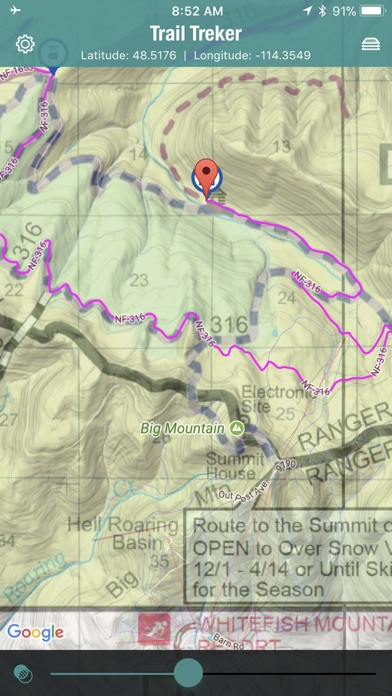
Trail Treker is a map viewing tool for use with the Trail Treker map publishing service. Trail Treker works with clubs, tourism agencies and municipalities to make their maps work offline on end user smartphones. Once the map is loaded, you no longer need phone service; the GPS receiver in your phone will operate without phone service. In fact, we recommend that you place your phone in Airplane Mode if you are in an area with limited or partial phone service to conserve your battery.
Trail Treker will also electronically, via GPS location, show local businesses and points of interest. You can store your own points of interest as well. Key points such as survival shelters, supplies, or emergency evacuation points may be shown on various maps.

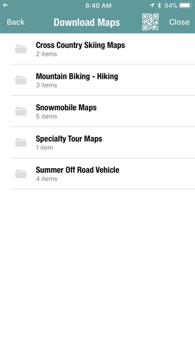
The Trail Treker app will allow you to download any member map. If you have a member map code, the map will be free. If not, the map will be an additional purchase.

Continued use of GPS in the background can decrease battery life.

FEATURES:
Show Trail map overlaid on various Google maps (Standard Street, Terrain, Satellite)
Show your position on top of any map.
Record your position and tracks
Record notes regarding position points
Share your saved positions or tracks with others
See local businesses on or near mapping area
Filter local businesses by category
Load and layer up to two maps concurrently and any number of tracks.
Load any number of maps (storage space required)
Show More

最新版本2.5.6更新日誌

Last updated on 2023年08月18日
歷史版本
Fixed/Added the ability to import a csv file with multiple POIs.
Show More
Version History
2.5.6
2023年08月18日
Fixed/Added the ability to import a csv file with multiple POIs.
2.5.5
2023年05月18日
Minor bug fixes related to import / export of tracks.
2.5.4
2023年01月25日
Minor bug fixes
2.5.3
2022年12月22日
New FindIt Feature that allows you to place a point on a map using Lat/Long Coords.

Added Full Screen Feature / button

Moved Location/Compass Mode button to top bar
2.5.2
2019年11月30日
Fixed issues for using on iOS 13.
2.5.1
2019年03月06日
Minor bug fixes and support for new phone formats.
2.5
2018年01月18日
Minor bug fixes.
2.4
2017年12月31日
Minor bug fixes
2.2
2017年12月01日
Support for iPhone X, minor bug fixes and updated terms and conditions.
2.1
2017年11月09日
We've added support for the iPhone X and minor bug fixes.
2.0
2017年10月27日
New POI Categories and Icons. We now have over 65 categories and the ability to classify a POI with multiple categories. A POI may be a Resort, Gas Station, Convenience Store, etc. A POI will always use the first category icon, but if categories are filtered, it will show the icon for the filtered category.

Tracking. You can now track your ride, get details on the miles/km travelled, speed, time, altitude and see exactly where you went or how you got to that special place. You can also share tracks with friends and import new tracks. When you click on the Layers button (upper right corner), you will now notice a Maps and Layers tab. This allows you to easily control which map and which track you wish to view. You can load two maps and multiple tracks at the same time. You can also control and change the color of any track by clicking on an end point of the displayed track. To start a new track, simply click the Tracking button in the main screen. To stop/save the track, click the red Tracking button. To see/edit the details, click on the displayed track and then click the details popup.

Night View Base Map. You can now place the base “google” map a night view mode which is dark with light roads. The actual trail map does not change.

Base map label control. On the main screen, you’ll notice a new button next to the base map selection tool. This control lets you turn on/off five different levels of base map labels. The levels represent the levels of roads (Freeways, US Highways, State Highways, Secondary roads, etc.). If a label is ever covering up some other feature on your map, now you can simply turn it off.

Base Map Caching. You can now cache the entire google base map under a map layer so that you always have the topographic or satellite view handy when in the back-country and you don’t have service. You can also select what zoom level(s) of base maps you want so that you are not caching every zoom level. The tool will also help you estimate the size of the chosen zoom levels.

Check out each of the help documents for more info on each tool!
1.0
2016年12月22日

Trail Treker 價格

今日:
HK$ 18.00
最低價格:
HK$ 15.00
最高價格:
HK$ 18.00

Trail Treker FAQ

點擊此處瞭解如何在受限國家或地區下載Trail Treker。
以下為Trail Treker的最低配置要求。
iPhone
須使用 iOS 9.0 或以上版本。
iPad
須使用 iPadOS 9.0 或以上版本。
iPod touch
須使用 iOS 9.0 或以上版本。
Trail Treker支持英文
Trail Treker包含應用內購買。 以下為Trail Treker應用內購買價格清單。
Sawyer County ATV ONLY Trails
HK$ 18.00
Chippewa County ATV Map
HK$ 18.00
Jewel Basin Hiking Area
HK$ 18.00
Adams County ATV Map
HK$ 18.00
Winnebago Cty
HK$ 18.00
Skalkaho-Rye Trail
HK$ 18.00
Skalkaho Pass Trail
HK$ 18.00
Lost Horse Trail Bitterroot
HK$ 18.00
Barron County ATV
HK$ 18.00
Barron County Snowmobile
HK$ 18.00

Trail Treker相關應用

你可能還喜歡