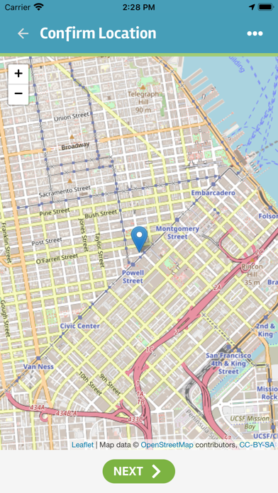
Show the Way allows street outreach workers, first responders, and others (“Navigators”) to quickly capture information about the exact location of an interaction, identify the person they are engaging with, conduct a “light touch” assessment, and track whatever services or resources were provided.
This tech offers the following benefits over the traditional pen and paper based approach:
• Real-time data capture
• Location tracking with exact GPS coordinates
• Option to look up clients with the built-in barcode scanner or by name and date of birth
• Ability to review details on past interactions by any member of the navigation team
• Customizable surveys support vulnerability assessments, determining unmet needs, and more
• Digital tracking of client consent to share information and to participate in coordinated entry
• Ability to capture pictures of key documents
• Navigators can log observations about people that cannot be engaged
• Encampments can be mapped and details on the encampment can be captured
• Follow ups and alerts inform the navigator of any actions that need to be taken
• Data can be integrated with information captured in HMIS to produce a more complete picture of an individual or family’s homeless history
• The Regional Command Center which receives the data collected from the Show the Way app contains dashboards, maps, reports, and data management tools geared towards providing a more collaborative response to street homelessness within a community.
People living on the street tend to be more vulnerable and more expensive to a community in terms of interactions with police, hospitalizations, and emergency room visits. Without better data collection however, those who prefer the streets to shelter tend to be ranked lower than their peers by the tools used to prioritize people for housing. The improved data collection supported by Show the Way provides crucial documentation of each person’s history of homelessness while providing navigators with the tools to better meet their needs.