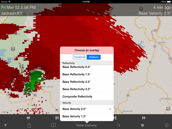
Dual Radar US is the only app in the app store that provides beautiful super hi-resolution (250 meter) radar mosaics for the continental United States AND images directly generated from raw Nexrad Level 3 station data. This lets you either view the big picture of what's going on with the weather, or view radar products that can't be combined into a mosaic, such as multi-scan level reflectivity, velocity, and dual polarization radar. Believe it or not, we offer access to about 40 different radar products.
But we didn't stop there! We also provide access to severe weather warnings, storm tracks, hurricane tracks, hourly precipitation forecasts, 7 day point forecasts, current temperature overlays, jet stream maps, and 3 and 6 day precipitation forecast precipitation and pressure maps and more.
If you're a detail person, feel free to read our complete list of features:
- Super resolution (0.25 km) radar composites
- Standard resolution (1 km) radar composites
- Most Nexrad station products, including reflectivity, composite reflectivity, base and storm velocity (all at 4 scan angles), vertically integrated liquid, echo tops, one hour and storm total precipitation.
- Most Nexrad dual polarization products, including differential reflectivity, correlation coefficient, specific differential phase, and hydrometeor classification at 4 scan levels
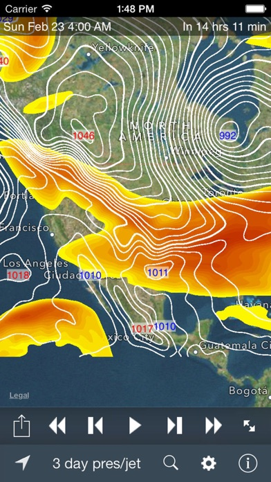
- 3 and 6 day precipitation and pressure forecasts from NOAA weather models
- 3 day jet stream forecast
- Temperature overlay
- Snow/mixed precipitation display (only on 1km base reflectivity radar layer)
- 7 day forecasts and current conditions -- just press and hold for a second on the radar map
- Hourly predicted radar
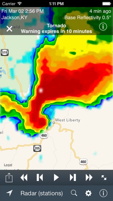
- Severe weather (flash flood, tornado, and severe thunderstorm) warnings. Tap on a warning box to display the full warning message from the National Weather Service. Note: these are *not* push alerts. The app must be open to view the warnings
- Cloud cover and satellite imagery for the continental United States
- Advanced radar layers (echo tops, composite reflectivity, and storm total precipitation).
- Play, pause, and step animations
- Fast zoom in and zoom out
- Choice of radar palettes
- Multiple map styles (terrain, map, satellite, and hybrid)
- Displays time of radar image either as absolute time or relative to the current time
- GPS locator that finds and displays your current location
- Adjust the transparency (opacity) of the radar or cloud cover overlays
- Radar clutter filtering and smoothing
- Automatic refresh when new radar or cloud cover data is available
- Search for a location by zip code, city name, or address
- Legend for radar and cloud cover overlays
- Saves and restores your last location and zoom level
Note: Radar coverage only includes the continental United States. Alaska, Hawaii, and other US controlled territories are not included.
Note: Our Notification Widget is no longer supported due to MapQuest's decision to no longer offer a map tile service.
Support:
Please follow our Twitter stream at twitter.com/shuksansoft for breaking news and status updates.