New in 3.0.12:
▪ Bug fixes and performance enhancements.
New in 3.0.x:
▪ Copy to clipboard added to map share sheet.
▪ Bug fixes and performance enhancements.
▪ iOS 15 compatibility.
▪ Support for Dark Mode.
▪ GPS updates and enhancements.
▪ Improved ability for the BatchGeo app to open a map URL that was tapped in another app.
▪ Ability to filter My Maps, only showing maps you own instead of all maps in your organization.
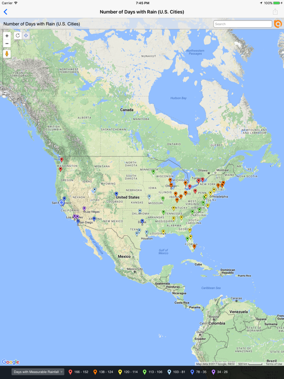
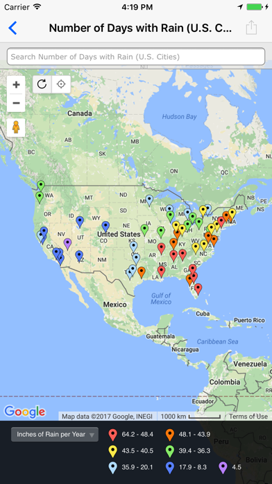
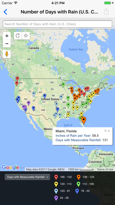
▪ Works with all data display styles including point symbols and colors, point clustering, pie charts and, if available, heat maps.
▪ Select, filter and zoom to map data.
▪ Now share maps via email or iMessage.
New in 3.0.11:
▪ Copy to clipboard added to map share sheet.
▪ Bug fixes and performance enhancements.
New in 3.0.x:
▪ iOS 14 compatibility.
▪ Support for Dark Mode.
▪ GPS updates and enhancements.
▪ Improved ability for the BatchGeo app to open a map URL that was tapped in another app.
▪ Ability to filter My Maps, only showing maps you own instead of all maps in your organization.
▪ Adds support for iPhone X.
▪ Re-written to support iOS 10+.
▪ Works with all data display styles including point symbols and colors, point clustering, pie charts and, if available, heat maps.
▪ Select, filter and zoom to map data.
▪ Now share maps via email or iMessage.
New in 3.0.10:
▪ iOS 14 compatibility.
▪ Bug fixes and performance enhancements.
New in 3.0.x:
▪ Support for Dark Mode.
▪ GPS updates and enhancements.
▪ Improved ability for the BatchGeo app to open a map URL that was tapped in another app.
▪ Ability to filter My Maps, only showing maps you own instead of all maps in your organization.
▪ Adds support for iPhone X.
▪ Re-written to support iOS 10+.
▪ Works with all data display styles including point symbols and colors, point clustering, pie charts and, if available, heat maps.
▪ Select, filter and zoom to map data.
▪ Now share maps via email or iMessage.
New in 3.0.9:
▪ Bug fixes and performance enhancements.
New in 3.0.x:
▪ Support for Dark Mode.
▪ GPS updates and enhancements.
▪ Improved ability for the BatchGeo app to open a map URL that was tapped in another app.
▪ Ability to filter My Maps, only showing maps you own instead of all maps in your organization.
▪ Adds support for iPhone X.
▪ Re-written to support iOS 10+.
▪ Works with all data display styles including point symbols and colors, point clustering, pie charts and, if available, heat maps.
▪ Select, filter and zoom to map data.
▪ Now share maps via email or iMessage.
New in 3.0.8:
▪ Support for Dark Mode.
▪ GPS updates and enhancements.
▪ Bug fixes and performance enhancements.
New in 3.0.x:
▪ Improved ability for the BatchGeo app to open a map URL that was tapped in another app.
▪ Ability to filter My Maps, only showing maps you own instead of all maps in your organization.
▪ Adds support for iPhone X.
▪ Re-written to support iOS 10+.
▪ Works with all data display styles including point symbols and colors, point clustering, pie charts and, if available, heat maps.
▪ Select, filter and zoom to map data.
▪ Now share maps via email or iMessage.
New in 3.0.7:
▪ Improved ability for the BatchGeo app to open a map URL that was tapped in another app.
▪ Bug fixes and performance enhancements.
New in 3.0.x:
▪ Ability to filter My Maps, only showing maps you own instead of all maps in your organization.
▪ Adds support for iPhone X.
▪ Re-written to support iOS 10+.
▪ Works with all data display styles including point symbols and colors, point clustering, pie charts and, if available, heat maps.
▪ Select, filter and zoom to map data.
▪ Now share maps via email or iMessage.
New in 3.0.6:
▪ Fixes iPad crash when attempting to share map.
New in 3.0.X:
▪ Bug fixes and many performance enhancements .
▪ Ability to filter My Maps, only showing maps you own instead of all maps in your organization.
▪ Adds support for iPhone X.
▪ Re-written to support iOS 10+.
▪ Works with all data display styles including point symbols and colors, point clustering, pie charts and, if available, heat maps.
▪ Select, filter and zoom to map data.
▪ Now share maps via email or iMessage.
New in 3.0.5
▪ Bug fixes and many performance enhancements
▪ Ability to filter My Maps, only showing maps you own instead of all maps in your organization.
▪ Adds support for iPhone X
▪ Re-written to support iOS 10+
▪ Works with all data display styles including point symbols and colors, point clustering, pie charts and, if available, heat maps
▪ Select, filter and zoom to map data
▪ Now share maps via email or iMessage
New in 3.0.4
▪ Ability to filter My Maps, only showing maps you own instead of all maps in your organization.
▪ Adds support for iPhone X
▪ Re-written to support iOS 10+
▪ Works with all data display styles including point symbols and colors, point clustering, pie charts and, if available, heat maps
▪ Select, filter and zoom to map data
▪ Now share maps via email or iMessage
▪ Bug fixes and many performance enhancements
New in 3.0.3
▪ Adds support for iPhone X
▪ Re-written to support iOS 10+
▪ Works with all data display styles including point symbols and colors, point clustering, pie charts and, if available, heat maps
▪ Select, filter and zoom to map data
▪ Now share maps via email or iMessage
▪ Bug fixes and many performance enhancements
New in 3.0.2
▪ Re-written to support iOS 10+ and all current iOS devices.
▪ Works with all data display styles including point symbols and colors, point clustering, pie charts and, if available, heat maps.
▪ Select, filter and zoom to map data.
▪ Now share maps via email or iMessage.
▪ Bug fixes and many performance enhancements.
New in 3.0.1
▪ Re-written to support iOS 10 and all current iOS devices.
▪ Works with all data display styles including point symbols and colors, point clustering, pie charts and, if available, heat maps.
▪ Select, filter and zoom to map data.
▪ Now share maps via email or iMessage.
▪ Bug fixes and many performance enhancements.
New in 3.0.0
▪ Re-written to support iOS 10 and all current iOS devices.
▪ Works with all data display styles including point symbols and colors, point clustering, pie charts and, if available, heat maps.
▪ Select, filter and zoom to map data.
▪ Now share maps via email or iMessage.
▪ Bug fixes and many performance enhancements.
New in 2.1.4
▪ Fix iPad share map bug
New in 2.1.3
▪ Handle when device has not been configured to send email messages
New in 2.1.2
▪ Fix iPad search bug
New in 2.1.1
▪ Fix bug related to location services
New in 2.1.0
▪ Support for iOS 10
▪ Support for new Apple devices
▪ Bug fixes
New in 2.1.3
▪ Handle when device has not been configured to send email messages
New in 2.1.2
▪ Fix iPad search bug
New in 2.1.1
▪ Fix bug related to location services
New in 2.1.0
▪ Support for iOS 10
▪ Support for new Apple devices
▪ Bug fixes
New in 2.1.2
▪ Fix iPad search bug
New in 2.1.1
▪ Fix bug related to location services
New in 2.1.0
▪ Support for iOS 10
▪ Support for new Apple devices
▪ Bug fixes
New in 2.1.1
· Fix bug related to location services
New in 2.1.0
· Support for iOS 10
· Support for new Apple devices
· Bug fixes.
New in 2.1.0
· Support for iOS 10
· Support for new Apple devices
· Bug fixes.
New in 2.0.1
· Fixed text rendering problem that appeared with iOS 7.1
New in 2.0.0
· New iOS 7 user interface.
· Improved handling of maps containing large numbers of data points.
· Improved security and handling of password protected maps.
· Performance improvements.
· Improved stability.
· Bug fixes.
· New iOS 7 user interface.
· Improved handling of maps containing large numbers of data points.
· Improved security and handling of password protected maps.
· Performance improvements.
· Improved stability.
· Bug fixes.
Adds compatibility with iOS6 and the iPhone 5.
New in 1.0.6
• Support for retina display in the new iPad.
• Bug fix for map not loading (currency data).
New in 1.0.5
• Filtering! Any combination of groups in your map may be used to filter the visible data. Simply touch one or more groups in your legend to add or remove them from the display.
• Search! Any data point containing an occurrence of your search string is returned in the search grid. Touch to pan and zoom to the selected point.
• Directions! A new button appears on the callout for each data point, allowing you to request directions from your current location to the data point.
• Share! Send a link to your map via email. Those who have BatchGeo mobile will have the map added to their maps as a shared map. Swipe to delete shared maps from your list.
• Bug Fixes & Optimizations! We are working hard to ensure that BatchGeo opens all your maps and delivers a stable and responsive experience.
This version of BatchGeo delivers important new and often requested features:
- Filtering! Any combination of groups in your map may be used to filter the visible data. Simply touch one or more groups in your legend to add or remove them from the display.
- Search! Any data point containing an occurrence of your search string is returned in the search grid. Touch to pan and zoom to the selected point.
- Directions! A new button appears on the callout for each data point, allowing you to request directions from your current location to the data point.
- Share! Send a link to your map via email. Those who have BatchGeo mobile will have the map added to their maps as a shared map. Swipe to delete shared maps from your list.
- Bug Fixes & Optimizations! We are working hard to ensure that BatchGeo opens all your maps and delivers a stable and responsive experience.
- Fixes for some maps not displaying any data points.